Give us feedback!

Our philosophy is simple. We want to encourage you to dream. BIG! Then we help you plan your trip, get the most out of it while you're traveling and help you share your experience with friends.
Join Now It's FREE
Dreams Still To Do
Checked-Off Dreams
Dreams Still To Do
Checked-Off Dreams
Advertisement
Explore Landmarks (Natural)
-
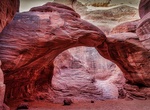
Hike to Sand Dune Arch, Arches National Park, Utah
Sand Dune Arch is a shaded, ground-level archin Arches National Park. The trail is a 0.3 mile out and back hike to the arch. Do not climb or jump off arch. -
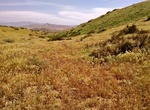
Explore Sand Ridge Wildflower Preserve, California
Sand Ridge Wildflower Preserve is a remnant natural area displaying a great diversity of floral species, including the native Bakersfield cactus, a species becoming increasingly rare in this locality. -
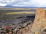
Visit Sandstone Bluffs, New Mexico
Sandstone Bluffs offers one of the few overlooks within all of El Malpais National Monument. Every direction you turn gives you a different view with a different feature to observe. Below the bluffs are the lava flows of El Malpais. To the north is a dramatic view of Mount Taylor. Below your feet is Dakota Sandstone that contrasts with the dark lava flows farther belo... -
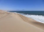
Visit Sandwich Harbour, Namibia
Sandwich Harbour is a port on the Atlantic coast of Namibia, lying south of Walvis Bay, within the Namib-Naukluft National Park. Formerly a moderately-sized commercial port based around whaling and small-scale fishing, it declined as the harbour silted up, and is now best known for its birdlife. Although called Sandwich Harbour it was never a harbour or even a port. I... -
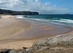
Hike to Sandwood Bay, Scotland
Sandwood Bay is a natural bay in Sutherland, on the far north-west coast of mainland Scotland. It is best known for its remote 1 mile (1.6 km) long beach and Am Buachaille, a sea stack, and lies about 5 miles (8.0 km) south of Cape Wrath. Behind the bay's large dunes, stretches the freshwater Sandwood Loch. Though remote, and with no road access, the bay can be reache... -
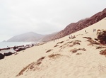
Visit Sandy Dune, Malibu, California
Sandy Dune is along the Pacific Coast Highway in the Malibu area of California. -
Explore Sandy Hook, New Jersey
Sandy Hook is a barrier spit, approximately 6.0 miles (9.7 km) in length and varying between 0.10 and 1 miles (0.16-1.61 km) wide in Middletown Township in Monmouth County, along the Atlantic Ocean coast of eastern New Jersey in the United States. The barrier spit encloses the southern entrance of Lower New York Bay south of New York City. The Dutch called the area "S... -
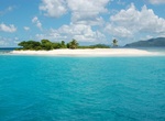
Visit Sandy Spit, British Virgin Islands (BVI)
Sandy Spit is an uninhabited islet of the British Virgin Islands in the Caribbean located between Sandy Cay and Green Cay. It measures less than half an acre in size, and consists entirely of a ring of sandy beach surrounding light foliage. It is an ideal spot for exploring, snorkeling and discovering the protected bird park. The reef off the South side offers the bes... -
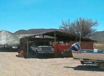
Visit San Evaristo, Baja California Sur, Mexico
San Evaristo is a little village of 15 families and between 80 and 100 people. It's at the northern end of the coastal road north from La Paz, Baja California Sur. It's approx 45.5 miles on a dirt road from La Paz. It's 3-4-1/2 hour ride from the Hwy 1 Y that is north of La Paz. There is no electricity, no telephone, so villagers needed to climb a fairly high hill to... -
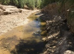
Explore San Felipe Creek (Salton Sea), San Diego County, California
San Felipe Creek is a stream in Imperial and San Diego Counties of California. It arises in the Volcan Mountains of San Diego County 33°11′57″N 116°37′35″W / 33.19917°N 116.62639°W / 33.19917; -116.62639, and runs eastward, gathering the waters of most of the eastern slope of the mountains and desert of the county before it empt... -
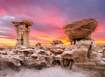
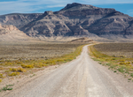
Explore San Juan Basin Badlands in New Mexico
The San Juan structural basin in the northwest corner of New Mexico, south of US 64. Much of the area is part of Indian reservations (Navajo, Jicarilla Apache, Jemez and Zia), and although outwardly empty and barren has some of the great rock formations in the western US. The most well know site is Chaco Culture National Historical Park. The badland regions include B... -
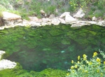
Visit San Kamphaeng Hot Springs, Chiang Mai, Thailand
Hot Springs in San Kamphaeng are located closeby Chiang Mai. You can rent a scooter and easily get to the beautiful, well maintained gardens. There is a geiser, spring pool which water's cooler but still very hot. You can buy some eggs and boil them in the water for a snack too! -
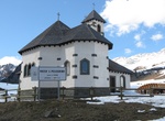
Visit San Pellegrino Pass, Dolomites, Italy
The San Pellegrino Pass (Passo San Pellegrino) (1918 m) is a high mountain pass in the Italian Dolomites. It connects the municipalities of Moena and Falcade. The ski resort of Trevalli is located at the pass. The area is also popular in summer for rock climbing. The peak of Cima Uomo and Col Margherita stand nearby on the north and the south sides. During World ... -
Explore San Rafael Swell, Utah
The San Rafael Swell is a large geologic feature located in south-central Utah, United States about 16 miles (26 km) west of Green River. The San Rafael Swell, measuring approximately 75 by 40 miles (121 by 64 km), consists of a giant dome-shaped anticline of sandstone, shale, and limestone that was pushed up during the Paleocene Laramide Orogeny 60–40 million y... -
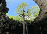
Swim at Santa Barbara Cenotes (Cenote Xoch, Cascabel & Chacksikin), Homún, Yucatán, Mexico
Santa Barbara Cenotes has a restaurant and has 3 cenotes that are within a 1 to 2-minute walk from each other and about 10 minutes from the restaurant. The facilities are clean and in good condition. There are changing rooms, showers, and bathrooms. They also provide life vests without you having to ask for them. Cenote Cascabel – The entrance to the cen...