Give us feedback!

Our philosophy is simple. We want to encourage you to dream. BIG! Then we help you plan your trip, get the most out of it while you're traveling and help you share your experience with friends.
Join Now It's FREE
Dreams Still To Do
Checked-Off Dreams
Dreams Still To Do
Checked-Off Dreams
Advertisement
Explore Landmarks (Natural)
-
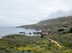
Hike Soberanes Pt Trail, Garrapata State Park, California
It's a short hike to Painters Point in Garrapata State Park. Cross over a small bridge with a waterfall below. -
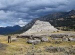
See Soda Butte, Yellowstone National Park, Wyoming
Soda Butte is a hot spring cone about two and a half miles above the mouth of Soda Butte Creek. -
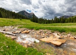
Fish Soda Butte Creek, Yellowstone National Park, Wyoming
Soda Butte Creek is an approximately 20 miles (32 km) long major tributary of the Lamar River in Yellowstone National Park. It is named for a now-extinct geyser (Soda Butte) near its mouth. Soda Butte and the creek were named by A. Bart Henderson, a Cooke City miner, in 1870. It rises just outside the northeast corner of the park on the southern slopes of the Absaroka... -
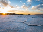
Explore Soda Dry Lake, Carrizo Plain National Monument, California
Soda Lake (or Soda Dry Lake) is a dry lake at the terminus of the Mojave River in the Mojave Desert of San Bernardino County, California. The lake has standing water during wet periods, and water can be found beneath the surface. Soda Lake along with Silver Lake are what remains of the large, perennial, Holocene Lake Mojave. The waters of the lake, now with no outlet,... -
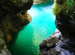
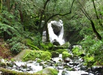
Hike to Soffia Waterfall (Cascata della Soffia), Dolomiti Bellunesi National Park, Italy
Soffia Waterfall (Cascata della Soffia) is located north of Lake Mis in Dolomiti Bellunesi National Park, Italy. -
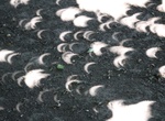
See Solar Eclipse Tree Leave Pinhole Camera Affect
During a solar eclipse, tree leaves act like pinhole cameras, projecting images of the sun onto the ground. This is called the "Pinhole Camera" effect. Sunlight passes through gaps between tree leaves and the gaps in the leaves act like pinhole projectors, creating images of the sun on the ground. The images are crescent-shaped during a partial eclipse, or ring-shaped... -
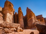
See Solomon's Pillars, Timna Valley, Israel
The most striking and well-known formation in Timna Valley are Solomon's Pillars. The pillars are natural structures that were formed by centuries of water erosion through fractures in the sandstone cliff until it became a series of distinct, pillar-shaped structures. American archaeologist Nelson Glueck caused a surge of attention for the pillars in the 1930s. He cla... -
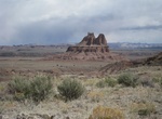
See Solomon's Temple in Cathedral Valley, Utah
Solomon's Temple is located outside of Capitol Reef National Park but can be accessed from Cathedral Valley Road via a road just west of Gypsum Sinkhole Road. -
See Sonoma Creek Falls, California
The Sonoma Creek falls in Sugarloaf Ridge State Park has a 25 foot descent, landing on boulders and jagged rocks of the creek below with maple trees and ferns shading the area. It is best to visit during the rainy winter season and can be seen even from the campground. Sugarloaf Ridge State Park is a state park in Northern California, U.S.A.. Located in the Mayacamas ... -
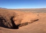
Explore Sooner Rocks, Hole-in-the-Rock Road, Utah
Sooner Rocks is about 40 miles down the Hole-in-the-Rock road. Sooner Rocks is an outcropping of one of the upper layers of Entrada sandstone. Be careful around the potholes. The big pit is over 100 feet across and about 80 feet deep. Recommend high clearance vehicles to this site. -
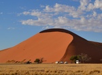
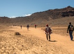
Explore Sossusvlei, Namibia
Sossusvlei (sometimes written Sossus Vlei) is a salt and clay pan surrounded by high red dunes, located in the southern part of the Namib Desert, in the Namib-Naukluft National Park of Namibia. The name "Sossusvlei" is often used in an extended meaning to refer to the surrounding area (including other neighbouring vleis such as Dead Vlei and other high dunes), which i... -
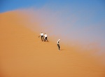
Climb Sossusvlei Dune 45, Namibia
Dune 45 is situated at the 45th kilometer of the road starting from the locality of Sesriem, to the northeast, and crossing from east to west the Sossusvlei, a salar of the Namib desert surrounded by high dunes; the mileage gives its name to the place. The foot of the dune is only 300 m south of the road, directly accessible by all-terrain vehicle. The dune rises to ... -
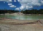
See Sour Lake, Yellowstone National Park, Wyoming
Sour Lake is in Yellowstone’s Mud Volcano Group, on the western side of the Yellowstone River, north of Yellowstone Lake. -
Cross South Crater, Tongariro Alpine Crossing, Tongariro National Park, New Zealand
The steaming moonscape of South Crater is at 6.4 km (4.0 mi) on the Tongariro Alpine Crossing. -
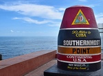
Visit Southernmost Point of the Continental US Buoy, Key West, Florida
The Southernmost Point Buoy is an anchored concrete buoy in Key West, Florida, marking the southernmost point in the continental United States, the lowest latitude land of contiguous North American States. It is 18 feet above sea level. The large painted buoy was established as a tourist attraction in 1983 by the city at the corner of South Street and Whitehead Street...