Give us feedback!

Our philosophy is simple. We want to encourage you to dream. BIG! Then we help you plan your trip, get the most out of it while you're traveling and help you share your experience with friends.
Join Now It's FREE
Dreams Still To Do
Checked-Off Dreams
Dreams Still To Do
Checked-Off Dreams
Advertisement
Explore Landmarks (Natural)
-
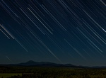
Go Stargazing in Jasper National Park, Alberta, Canada
In 2011, Jasper National Park received a Dark Sky Preserve designation from the Royal Astronomical Society of Canada. Today it is the second largest and most accesible preserve in the world at 11,000 sq km (4,247 sq mi). Some of the best sites include: Tonquin Valley Medicine Lake Maligne Canyon Pyramid Lake Mount Edith Cavell Athabasca Falls Columbia Icefie... -
Go Stargazing in Katahdin Woods and Waters National Monument, Maine
Starry nights at Katahdin Woods and Waters National Monument are exceptional, with night sky readings that prove the monument and its surrounding neighbors have some of the darkest skies east of the Mississippi. Within its 87,564 acres there are no electric lights and no commercial power sources. Katahdin Woods and Waters National Monument is an International Dark Sk... -
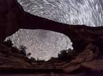
Go Stargazing in Natural Bridges National Monument, Utah
Imagine sitting on a warm summer night looking through a massive natural bridges hidden in a canyon in remote southeast Utah. Thousands of years ago a river changed course, cutting through solid rock and creating one of the most magnificent natural bridges in the world. The bridge forms a window into a sky filled with thousands of stars bright enough to cast a shadow.... -
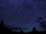
Go Stargazing in Valley of the Gods, Utah
Valley of the Gods in Utah is an excellent location for stargazing due to its remote location and minimal light pollution, offering expansive views of the night sky. It's a free BLM area with stunning rock formations, making it ideal for both photography and simply enjoying the dark skies. -
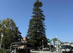
See Star Pine Tree (Heritage Tree #3) & Rotary Park, Coronado, California
Located in Rotary Plaza was designated a Heritage Tree on April 3, 2008. This Araucaria Heterophylla is native to Norfolk Island in the SW Pacific and was transplanted to this location by Supt. Bandel in 1936. The project was funded by the Coronado Rotarians and has since served as the City's living Christmas tree. Star pines can grow to 100 feet in height. Loc... -
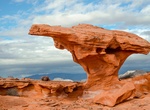
See Starship Rock, Little Finland, Nevada
Starship Rock is one of the rock formation in Little Finland in Gold Butte National Monument, Nevada. -
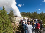
See Steamboat Geyser, Norris Geyser Basin, Yellowstone National Park
Steamboat Geyser, in Yellowstone National Park's Norris Geyser Basin, is the world's tallest currently-active geyser. During major eruptions, water may be thrown more than 300 feet (90 m) into the air. Steamboat's major eruptions last from 3 to 40 minutes, and are followed by powerful jets of steam. Steamboat does not erupt on a predictable schedule, with recorded int... -
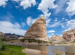
See Steamboat Rock, Dinosaur National Monument, Colorado
Nearly every campsite in the Echo Park Campground has sweeping views of Steamboat Rock and the cliffs around Echo Park. -
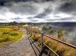
Hike to Steaming Bluff (Wahinekapu), Hawaii Volcanoes National Park, Hawaii
Visitors may enjoy the short walk on a trail leading from the Steam Vents parking area (Crater Rim Drive) to Steaming Bluff, on the caldera's edge. The area is a grassy meadow with ground cracks and steaming concentrated in fractures along the caldera's edge. -
Visit Steam Vents, Hawaii Volcanoes National Park, Hawaii
After leaving Kīlauea Visitor Center on Crater Rim Drive, 0.8 miles ahead on the left are Steam Vents. Ground water seeps down to the hot volcanic rocks in this area and returns to the surface as steam. While standing at the Steam Vents, take a good look around. The area between the caldera's edge and outer cliffs of Kīlauea Caldera is a treeless plain. The ground jus... -
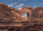
See Stevens Arch (Coyote Gulch), Utah
Just outside the mouth of the Coyote Gulch canyon and high above the Escalante River, is Stevens Arch. With an opening approximately 220 feet (67 m) wide and 160 feet (49 m) high, it is an excellent example of the arch-forming ability of Navajo sandstone. It is only reachable by hiking Coyote Gulch. It is located within both the Grand Staircase-Escalante National Mon... -
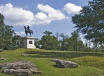
See Stevens Knoll, Gettysburg National Military Park, Pennsylvania
Southeast of the town of Gettysburg, the high ground of Culp's Hill and Cemetery Hill is connected by a low ridge dominated by a little knoll. Since the battle on July 1-3,1863, this connecting area has been known as Stevens Knoll, after Captain Greenleaf Stevens, the commander of the 5th Maine Battery (Battery E, Maine Light Artillery) that occupied it and fought of... -
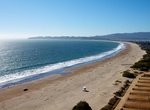
Visit Stinson Beach, California
Stinson Beach is located 2.5 miles (4 km) east-southeast of Bolinas, at an elevation of 26 feet (8 m). Stinson Beach is about a 35-minute drive from the Golden Gate Bridge on California's Highway 1. It is near important attractions such as Muir Woods National Monument, Muir Beach, and Mount Tamalpais. It has a long beach, where the cold water promotes fog throughout t... -
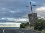
Visit Stirling Point, Bluff, New Zealand
Stirling Point is a landmark at the southern end of the New Zealand town of Bluff, New Zealand. It is notable as the southern end of both State Highway 1 and the Te Araroa Trail; both these facilities span the length of the country. Stirling Point hosts a signpost with multiple directional signs; it is one of the most photographed items in Southland. Stirling Point ha... -
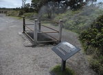
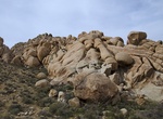
Hike Stirrup Tank/Stirrup Rock Area, Joshua Tree National Park, California
The Stirrup Tank/Stirrup Rock area is a great place to day hike, scramble and photography. Look around for the hidden dam, Native American campsites with bedrock mortars, pictographs and petroglyphs. It's located south of White Tank Campground. It's about 4 miles (3 hours) to walk around the formation or you can drive the dirt road to a small parking area next to th...