Give us feedback!

Our philosophy is simple. We want to encourage you to dream. BIG! Then we help you plan your trip, get the most out of it while you're traveling and help you share your experience with friends.
Join Now It's FREE
Dreams Still To Do
Checked-Off Dreams
Dreams Still To Do
Checked-Off Dreams
Advertisement
Explore Landmarks (Natural)
-
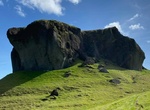
See Systrastapi (Sister’s Rock), Kirkjubæjarklaustur, Iceland
Systrastapi (“Sister's Rock”) is a historical rock west of the village of Kirkjubæjarklaustur, in South Iceland. In the 14th century two nuns of the Benedictine convent were burnt at the stake, one for fornication & selling her soul to the Devil and the other for speaking blasphemously of the pope. It is said that their remains are buried on top ... -
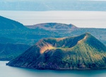
Explore Taal Volcano, Luzon, Philippines
Taal Volcano is a large caldera filled by Taal Lake in the Philippines. Located in the province of Batangas, the volcano is the second most active volcano in the Philippines, with 34 recorded historical eruptions, all of which were concentrated on Volcano Island, near the middle of Taal Lake. The caldera was formed by prehistoric eruptions between 140,000 and 5,380 BP... -
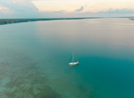
See Taam Ja' Blue Hole in Chetumal Bay, Yucatán Peninsula, Mexico
Taam Ja' blue hole is an underwater sinkhole located in Chetumal Bay at the southeast corner of the Yucatán Peninsula. Its name means deep water in the Mayan language and, at over 420 metres (1,380 ft) deep, it is the deepest known blue hole. Blue holes generate a distinctive blue color when seen from above and are typically only a few dozen meters deep. I... -
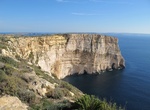
See Ta' Ċenċ Cliffs (Sanap Cliffs), Gozo, Malta
Ta' Ċenċ Cliffs is a 20 ha linear strip of cliffed coastline at Sannat, on the southern coast of the island of Gozo, Malta, in the Mediterranean Sea. The area consists of garrigue and steep and rugged cliffs, which rise from sea level to a height of 120 m. The cliffs are identified as an Important Bird Area (IBA) by BirdLife International because they support 800&ndas... -
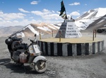
Visit Taglang La Pass, Ladakh, India
Taglang La or Tanglang La, elevation 5,328 metres (17,480 ft), is a high altitude mountain pass in the Indian union territory of Ladakh. It is located on the NH3 Leh–Manali Highway. Rail-cum-road tunnels are being constructed under the Taglang La, Lungalacha La (87 km south of Taglang La) and Bara-lacha la (171 km south of Taglang La) to cater for... -
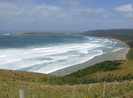
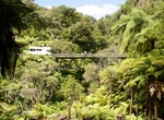
Hike Tahakopa Bay Walk, Purakauiti, New Zealand
The Tahakopa River flows southeastward through the Catlins, an area of the southern South Island of New Zealand. Its total length is 32 kilometres (20 mi), and it flows into the Pacific Ocean 30 kilometres (19 mi) east of Waikawa, close to the settlement of Papatowai. The Maclennan River is a tributary. The river's source is to the west of Mt Pye, 25 kilometres (16 mi... -
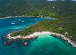
Visit Tai She Wan, Hong Kong
Tai She Wan, on the western coast of High Island, Hong Kong. -
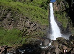
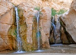
Visit Takapala Waterfall, Sulawesi, Indonesia
Takapala Waterfall is the thousand stairs waterfall. The way to get there is nice and in the shades of the trees. -
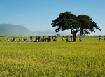
See Takeshi Kaneshiro Tree, Taiwan
Takeshi Kaneshiro Tree is a bishop wood located on Mr. Brown Avenue, Chihshang Township, Taitung County, Taiwan. Because of advertisements made in June 2013 by EVA Air with Takeshi Kaneshiro in this tree, it was named Takeshi Kaneshiro Tree. Since then, this tree has become a famous landmark attracting countless tourists to visit this place like a pilgrimage. It is es... -
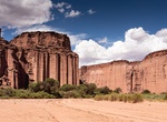
See Talampaya Gorge, Talampaya National Park, Argentina
The Talampaya gorge and its rock formations with walls of the Talampaya Formation of up to 143 metres (469 ft) high, narrowing to 80 metres (262 ft) at one point. -
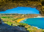
Visit Tal-Mixta Cave, Gozo, Malta
Tal-Mixta Cave on the island of Gozo, Malta is big and offers a great view over the beautiful beach on Ramla Bay. -
See Tamaraw Falls, Mindoro Island, Philippines
Tamaraw Falls is a 423-foot (129 m) waterfall, situated alongside the road, is actually a series of asymmetrical falls, leading to the grand one, dropping to a frothy waterbed below. The cascading waterfalls are a great attraction to passers-by. Tamaraw Falls is located in Barangay Villaflor, Puerto Galera. It can be reached in two hours by taking a jeepney bound for ... -
Visit Tamerza Oasis & Tamaghza Canyon, Tunisia
Tamerza (or Tamaghza) is the largest mountain oasis in Tunisia, known as Ad Turres by the Romans. It has a canyon and an abandoned old town. The town was abandoned after the river flooded for 22 days in 1969. It is located north of the salt lakes and receives fresh water from the nearby hills. It is in the hillcountry near the border with Algeria, and is 6 km (3.7 mi)... -
Drive through Tāngarākau Gorge, New Zealand
The Tāngarākau River is a river of the Taranaki and Manawatū-Whanganui regions of New Zealand's North Island. It flows south from its sources to the northeast of Whangamōmona in the King Country to reach the Whanganui River. State Highway 43, known as the Forgotten World Highway, travels through the Tāngarākau Gorge. -
Visit Tangkoko Batuangus Nature Reserve, Sulawesi, Indonesia
Tangkoko Batuangus Nature Reserve is a nature reserve in the northern part of Sulawesi island of Indonesia, two hours drive from Manado. The reserve covers an area of 8,700 hectares and includes three mountains: Mount Tangkoko (1,109 meters), Mount Dua Saudara (1,361 meters) and Mount Batuangus (450 meters). The most common trees in the lowland rainforest of the park ...