Give us feedback!

Our philosophy is simple. We want to encourage you to dream. BIG! Then we help you plan your trip, get the most out of it while you're traveling and help you share your experience with friends.
Join Now It's FREE
Dreams Still To Do
Checked-Off Dreams
Dreams Still To Do
Checked-Off Dreams
Advertisement
Explore Landmarks (Natural)
-
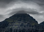
See Búlandstindur, Iceland
Búlandstindur is a mountain in Eastern Iceland between the bays Berufjörður and Hamarsfjörður. Mt. Búlandstindur is 1,069 metres (3,507 ft) above sea level. It is a pyramid-shaped stack of basaltic strata. -
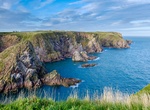
Explore Bullers of Buchan, Aberdeenshire, Scotland
The name Bullers of Buchan refers both to a collapsed sea cave and to the adjacent village, situated about 6 miles (9.7 km) south of Peterhead in Buchan, Aberdeenshire, Scotland. The collapsed sea cave forms an almost circular chasm (the "pot") some 30 metres (98 ft) deep, where the sea rushes in through a natural archway. The small hamlet of cottages here is also kno... -
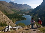
See Bullhead Lake (Glacier County, Montana)
Bullhead Lake is located in Glacier National Park, in the U. S. state of Montana. Mount Wilbur is North of Bullhead Lake. It's accessed from the Swiftcurrent Pass Trail. -
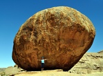
Hike to Bull's Party, Namibia
Bull's Party on farm Ameib is a great place to take photos depict the enormously impressing granite rock formations of Namibia. -
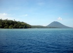
Visit Bunaken Island, Sulawesi, Indonesia
Bunaken is an island of 8 km2, part of the Bunaken National Marine Park. Bunaken is located at the northern tip of the island of Sulawesi, Indonesia. It belongs administratively to the municipality of Manado. Scuba diving attracts many visitors to the island. The waters of Bunaken National Marine Park are up to 1,566 m deep in Manado Bay, with temperatures ranging bet... -
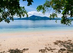
Visit Bunaken National Park, Sulawesi, Indonesia
Bunaken National Park is a marine park in the north of Sulawesi island, Indonesia. The park is located near the centre of the Coral Triangle, providing habitat to 390 species of coral as well as many fish, mollusc, reptile and marine mammal species. The park is representative of Indonesian tropical water ecosystems, consisting of seagrass plain, coral reef, and coasta... -
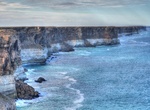
See Bunda Cliffs, South Australia
The Bunda Cliffs are part of a larger scarp of the Eucla Basin that spreads from the western part of South Australia across to the south eastern corner of Western Australia. As a geographical feature, they form part of the longest uninterrupted line of sea cliffs in the world. No other continent or country can match the cliffs for length of coastline. The Bunda cliffs... -
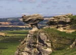
See Bunnet Stane, West Lomond, Scotland
The Bunnet Stane (orbonnet stone) is a rock formation near the hamlet of Gateside in Fife, at the foot of West Lomond. It sits upon one of the calciferous sandstone outcrops of the Old Red Sandstone suie that exist around the base of the Lomond Hills. The Bunnet Stane itself consists of an elevated table of rock, about ten feet by twenty feet across, which sits upon a... -
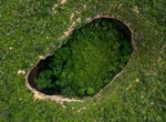
Visit Buraco do Possidônio, Morro do Chapéu State Park, Brazil
Buraco do Possidônio is a sink hole in Morro do Chapéu State Park, Brazil. -
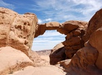
See Burdah Rock Bridge, Wadi Rum, Jordon
At the north ridge of Jabal Burdah stands the 35-meter high Burdah rock bridge. This bridge is the highest arch in Wadi Rum. Climbing up to the bridge takes about 3 hours going and coming back. Along the way, there are some steep parts. Hence this climb is not a fit if you have balance issues or are afraid of heights. -
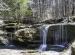
Explore Burden Falls Wilderness, Shawnee National Forest, Illinois
The Burden Falls Wilderness is a 3,775-acre (15.3 km²) unit of the Shawnee National Forest. It is located in northwestern Pope County and southwestern Saline County, Illinois. The wilderness is characterized by road-less second-growth hardwood forest, punctuated by a small, seasonal waterfall on Burden Creek.Burden Fallsfalls 20 feet (6 m) over a sandstone ledge,... -
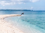
Explore Burias Pass, Luzon, Philippines
Burias Pass is the strait that separates Burias Island from the Bicol Peninsula in the Philippines. It connects the Ragay Gulf in the north with the Ticao Pass and Samar Sea in the south. It is considered a very important biodiversity area of the country. Along with the Ticao Pass, the waters of the Burias Pass are proposed to become a Marine Protected Area. The pass ... -
See Burmis Tree, Alberta, Canada
Burmis Tree is a limber pine located in south western Alberta in the community of Burmis, Alberta, along the Crowsnest Highway (Highway 3) and east of municipality of Crowsnest Pass. The tree died in the late 1970s after losing its needles. Limber trees are known to survive harsh conditions and are one of the longest living trees in Alberta. The Burmis tree was estima... -
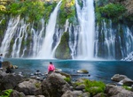
See Burney Creek Falls, Shasta County, California
Burney Falls is a waterfall on Burney Creek, within McArthur-Burney Falls Memorial State Park, in Shasta County, California. The water comes from underground springs above and at the falls, which are 129 feet high, and provides an almost constant flow rate of 379 million litres per day, even during the dry summer months. Burney Creek is a tributary of the Pit River, w... -
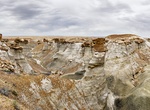
Explore Burnham Badlands, New Mexico
Burnham Badlands (an unofficial name) in the San Juan Basin offers hoodoos and the mounds are mixed with pieces of petrified wood. Located on Navajo Reservation land south of BIA 5 between Hwy 371 and US 491 in northwest New Mexico. Park along Indian Route 5080, 10 miles west of Hwy 371.