Give us feedback!

Our philosophy is simple. We want to encourage you to dream. BIG! Then we help you plan your trip, get the most out of it while you're traveling and help you share your experience with friends.
Join Now It's FREE
Dreams Still To Do
Checked-Off Dreams
Dreams Still To Do
Checked-Off Dreams
Advertisement
Explore Landmarks (Natural)
-
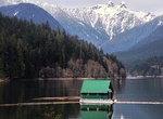
Explore Capilano River Regional Park, Vancouver, British Columbia
Capilano River Regional Park is located in the District of North Vancouver in British Columbia, Canada. It is one of twenty-one regional parks operated by the Metro Vancouver. The park encompasses most of the upstream areas of the Capilano River below the Cleveland Dam. The area north of the dam surrounding Capilano Lake is closed to the public as it is a GVRD watersh... -
See Capitol Dome, Capitol Reef National Park, Utah
Capitol Dome is a 6,120-foot-elevation (1,870 m) summit located in Capitol Reef National Park, in Wayne County, Utah, United States. This iconic landmark is situated 2.5 miles (4.0 km) east of the park's visitor center, and 0.85 mi (1.37 km) southeast of Navajo Dome. Precipitation runoff from this feature is drained by tributaries of the Fremont River, which in turn i... -
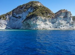
See Capo Bianco, Isola di Ponza, Italy
Capo Bianco ("Cape White") is an Italian National Natural Monument and located on the western side of Isola di Ponza. -
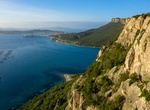
Explore Capo Figari, Sardinia
The coast ofCapo Figari (342m) is characterised by high cliffs. Trails crisscross and lead up to an abandoned lighthouse on the summit, known as il vecchio semaforo (old traffic light). It was from here that Guglielmo Marconi sent the first radio signal to the Italian mainland in 1928. -
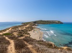
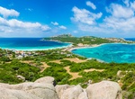
Explore Capo San Marco, Sardinia
Picturesque, unspoiled peninsula featuring white-sand beaches, ancient city ruins & a lighthouse. -
Explore Capo Testa, Sardinia
Cape Testa promontory is connected to the mainland by an isthmus and the structure is situated in the municipality of Santa Teresa di Gallura on the Sea of Sardinia. -
Visit Caprivi Strip, Namibia
Caprivi, sometimes called the Caprivi Strip, Okavango Strip and formerly known as Itenge, is a narrow protrusion of Namibia eastwards from the Kavango Region about 450 km (280 mi), between Botswana to the south, and Angola and Zambia to the north. Caprivi is bordered by the Okavango, Kwando, Chobe and Zambezi rivers. Its largest settlement is the town of Katima Mulilo... -
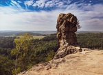
Hike to Čapská Palice, Czech Republic
Sandstone eroded rock formation above forest in CHKO Kokořínsko protected area. Located on Čap - Tschap hill near Duba, Czechia. -
Visit Captain Jack's Stronghold, California
Captain Jack's Stronghold, named for Modoc chief Captain Jack, is a part of Lava Beds National Monument. The stronghold can be accessed from the Perez turnoff, off Highway 139 between Tulelake and Canby, California. During the Modoc War, Captain Jack's band settled here following the Battle of Lost River, and held off a United States Army force outnumbering them by as... -
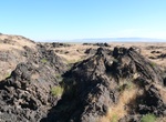
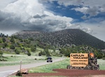
Explore Capulin Volcano National Monument, New Mexico
Capulin Volcano National Monument, located in northeastern New Mexico, was designated a U.S. National Monument on August 9, 1916. It is an example of an extinct cinder cone volcano that is part of the Raton-Clayton Volcanic Field. A paved road spirals around the volcano and visitors can drive up to a parking lot at the rim. Hiking trails circle the rim as well as lead... -
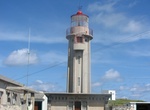
See Carapacho Lighthouse & Ponta da Restinga, Graciosa Island, Azores Islands
The Lighthouse of Carapacho is a beacon/lighthouse located along the cliffs of Ponta da Restinga, near the hamlet of Carapacho, civil parish of Luz on the island of Graciosa, the Portuguese archipelago of the Azores. The 1883Plano Geral de Alumiamento(Illumiation General Plan), proposed the construction of a fourth-order lighthouse, that would flash each minute and ha... -
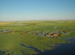
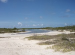
See Caribbean Flamingos on Anegada Salt Water Ponds, BVI
Anegada is also known for the large salt ponds which cover much of the west end of the island, These ponds, which support unique fauna, were designated a Ramsar Site on 11 May 1999. In the 1830s, thousands of Caribbean flamingos lived in these ponds, but they were hunted for food and feathers throughout the 19th and early 20th centuries and disappeared by 1950; they a... -
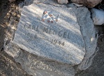
Visit Carl Mengel Grave & Mengel Pass, Death Valley National Park, California
Carl Mengel was a miner in Death Valley. He lost a leg in a mining accident, and continued to mine. His ashes and prosthetic leg are buried on top of Mengel Pass in Death Valley National Park. -
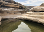
Off-road to Carlota Tinaja, Big Bend National Park, Texas
Tinaja Carlota is located along the dirt Old Ore OHV Road and is similar to nearby Ernst Tinaja. Tinaja is Spanish for a tank or pool. -
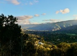
Explore Carmel Valley, California
Carmel Valley is a valley along the Carmel River east of California State Route 1. Carmel Valley has a number of wine tasting rooms, as well as several high-end hotels affiliated with the wineries. Wineries with tasting rooms in Carmel Valley include Holman Ranch, Bernardus, Boëté, Chateau Sinnet, Folktale, Galante, Georis, Heller Estate, Joullian Village,...