Give us feedback!

Our philosophy is simple. We want to encourage you to dream. BIG! Then we help you plan your trip, get the most out of it while you're traveling and help you share your experience with friends.
Join Now It's FREE
Dreams Still To Do
Checked-Off Dreams
Dreams Still To Do
Checked-Off Dreams
Advertisement
Explore Landmarks (Natural)
-
See Comet Geyser, Upper Geyser Basin, Yellowstone National Park, Wyoming
Comet Geyser is a geyser in the Upper Geyser Basin of Yellowstone National Park in the United States. Comet Geyser is part of the Daisy Group which includes Daisy Geyser, Splendid Geyser and Brilliant Pool. As opposed to the other features in this group, Comet erupts almost continuously. Every few minutes it surges to a height of 6 feet (1.8 m). This constant eruption... -
See Confluence of Havasu Creek and Colorado River, Arizona
The confluence of Havasu Creek with the Colorado River (river mile 157) is a popular place for boaters to stop and admire the striking blue-green water of Havasu Creek. The turquoise color is caused by water with a high mineral content. At the point where the blue creek meets the turbid colorado river there often appears a definite break. Camping is not allowed from 1... -
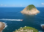
Visit Conic Island, Hong Kong
Conic Island is a small uninhabited island in Sai Kung District, Hong Kong. Located within Sai Kung East Country Park, the island lies a few hundred metres east of Tsang Pang Kok, Long Ke Wan. It is visible from Tsang Pang Kok, the East Dam of the High Island Reservoir, the eastern end of Man Yee Road as well as at the end of Stage 1 of the MacLehose Trail. There is a... -
See Cono de Arita (Arita Cone), Salar de Arizaro, Argentina
Cerro Cono (or Cono de Arita), a sandstone conical hill in Salar de Arizaro. -
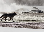
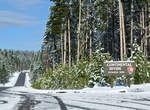
Visit Continental Divide (Yellowstone National Park), Wyoming
In the contiguous 48, the Continental Divide follows the spine of the Rocky Mountains for about 3,000 miles. Trails and roads through the Rockies frequently cross the divide. It crosses Hwy 191 in Yellowstone National Park in three different places. Craig Pass (elevation 8262') Elevation 8391 North of Riddle Lake Trailhead (Elevation 7988) -
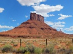
Climb Convent Mesa, Utah
Convent Mesa, or The Convent, or simply Convent, are alternative names for a 5,955-foot elevation sandstone summit in Grand County of Utah, United States. The Convent is located in Professor Valley, near the city of Moab. It is situated northeast of Parriott Mesa and southwest of the Fisher Towers area. The Convent is a 1,000 feet wide, and 3,000 feet long northwest-t... -
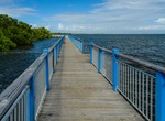
Hike Convoy Point Trail, Biscayne National Park, Florida
The canoe/kayak launch and greenspace at Convoy Point. -
See Cookie Jar Butte, Padre Bay, Lake Powell, Utah
Cookie Jar Butte is a tower in Kane County, Utah, in the United States with an elevation of 4,311 feet (1,314 m). It is located in Padre Bay on the north shore of Lake Powell. -
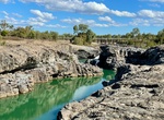
Explore Copperfield Gorge, Einasleigh, Queensland, Australia
Copperfield Gorge at Einasleigh was formed when the Copperfield River cut a path through the lava flows. Apparently there are several layers of volcanic rocks from various eruptions. The two bridges over the Copperfield into Einasleigh are visible in the background. The lower one is the train trestle bridge and the higher one is the new road bridge that leads to the ... -
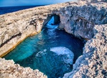
Visit Coral Lagoon, Malta
Coral lagoon It is one of the little secrets of the island of Malta. The water at the Coral Lagoon is crystal clear, making it popular with divers and snorkelers who explore the underwater caves. -
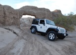
Off-road to Coral Wash Arch (Truckhaven Arch), Ocotillo Wells SVRA, California
This astounding arch is found along Coral Wash, one of the drainage channels in the northern area of Ocotillo Wells SVRA known locally as “Truckhaven.” Driving up Coral Wash offers the challenge of a variety of technical OHV maneuvers as one winds through the narrow walls lined with prehistoric layers -
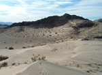
Visit Cornhole Mountain Dunes, Mojave National Preserve, California
Explore the small dunes at the northern end of the Cornhole Mountains. -
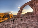
Hike to Corona & Bowtie Arch, Utah
Corona Arch is a natural sandstone arch near Moab, Utah in a side canyon of the Colorado River. Bowtie Arch is a pothole arch formed when a pothole broke through from the top of the cliff. They can be accessed via the Corona Arch Trail, a 1.5-mile (2.4 km) hiking trail from Utah State Route 279. -
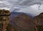
See Coronado Butte (Ayer Peak), Grand Canyon National Park, Arizona
Coronado Butte (Ayer Peak) is located on the South Rim of Grand Canyon National Park. This 7,108 fett (2,166 m) peak is east of Hance Canyon and was originally named for Mrs. Ed E. Ayer, the first non-native woman to descend the Grand Canyon at this place. It is now called Coronado Butte. Best seen from from Buggeln Hill on the Desert View Drive. Buggeln Hill is ... -
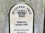
Tour Coronado Heritage Trees, Coronado, California
Coronado's Heritage Tree Program has been adopted by the Coronado Street Tree Committee for the purpose of identifying, promoting awareness, maintaining and protecting designated Heritage Trees located within the City. This Program acknowledges that Heritage Trees, whether located on public or private property, are distinct and unique living resources of our community...