Give us feedback!

Our philosophy is simple. We want to encourage you to dream. BIG! Then we help you plan your trip, get the most out of it while you're traveling and help you share your experience with friends.
Join Now It's FREE
Dreams Still To Do
Checked-Off Dreams
Dreams Still To Do
Checked-Off Dreams
Advertisement
Explore Landmarks (Natural)
-
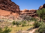
Hike Courthouse Wash, Arches National Park, Utah
Courthouse Wash is within Arches National Park, Utah. Start the hike at either Willow Springs Road or Arches National Park Road. -
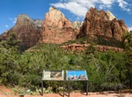
See Court of the Patriarchs, Zion National Park, Utah
The Court of the Patriarchs' is a sandstone cliff on the south face of the Three Patriarchs in Zion Canyon in Zion National Park in Washington County, Utah, United States. Spring and fall are the most favorable seasons to visit Court of the Patriarchs. According to the Köppen climate classification system, it is located in a cold semi-arid climate zone, which is ... -
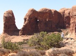
See Cove Arch, Arches National Park, Utah
Cove Arch is located in the Windows Section of Arches National Park. -
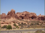
See Cove of Caves, Arches National Park, Utah
Cove of Caves is located in the Windows Section of Arches National Park. -
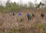
Hike Cowles Bog Trail, Indiana Dunes National Park, Indiana
Cowles Bog Trail is reached off of North Mineral Springs Road. Parking is to the east of the guard shack for Dune Acres. This 5-mile (8.0 km) loop is one of the most rugged trails in the park. Visitors begin with a long level walk skirting the wetlands of the Cowles Bog complex and the dune ridges to the north. Following the first fork to the north, they must climb th... -
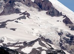
See Cowlitz Glacier, Mount Rainier National Park
The Cowlitz Glacier is on the southeast flank of Mount Rainier in the U.S. state of Washington. The body of ice covers 1.3 square miles (3.4 km2) and has a volume of 6 billion ft3 (170 million m3). The glacier starts at an elevation of 10,700 feet (3,300 m) and flows southeast. An adjacent glacier, the Paradise Glacier, is connected to this glacier on its southwe... -
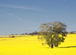
See Cowra Canola Fields, Cowra, New South Wales, Australia
Cowra is a small country town in New South Wales that has become an tourist attraction for its canola fields. -
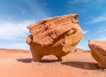
See Cow Rock (Chicken Rock), Wadi Rum, Jordon
Cow Rock (also known as Chicken Rock) has eroded at its base to appear as a large torso on short legs. -
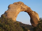
See Cox Canyon Arch, New Mexico
Cox Canyon Arch is located 12 miles north of Aztec, New Mexico. Thisgolden arch is approximately 35 feet wide, with an 18 foot wide opening. Other arches are around Aztec spread throughout the countryside. -
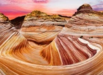
Explore Coyote Buttes North, Arizona & Utah
Coyote Buttes North (The Wave) is a small part of the 112,500-acre Paria Canyon-Vermilion Cliffs Wilderness and have some of the most visually striking geologic sandstone formations in the world. You must have a permit to visit Coyote Buttes North (The Wave). Permits are available for day use only. There is a daily limit on permits. Permits for Coyote Buttes North (T... -
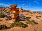
Explore Coyote Buttes South, Arizona
Coyote Buttes South is a small part of the 112,500-acre Paria Canyon-Vermilion Cliffs Wilderness and have some of the most visually striking geologic sandstone formations in the world. Coyote Buttes South might not have as good a superb photographic opportunities as Coyote Buttes North, it does offer a less crouded enviroment. Coyote Buttes South has two trailheads... -
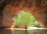
See Coyote Natural Bridge, Coyote Gulch, Utah
Coyote Natural Bridge is a small hole carved in a large sandstone fin along the Coyote Gulch downstream from Jacob Hamblin Arch (also known as Lobo Arch). It is only reachable by hiking Coyote Gulch. It is located within both the Grand Staircase-Escalante National Monument (upper sections) and the Glen Canyon National Recreation Area (lower sections). -
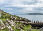
Visit Craignish Point, Scotland
Craignish (Scottish Gaelic, Creiginis) is a peninsula in Argyll and Bute, on the west coast of Scotland. It lies around 25 miles (40 km) south of Oban, and 10 miles (16 km) north-west of Lochgilphead. The peninsula is around 5.5 miles (8.9 km) long, and is aligned along a north-east to south-west orientation, in common with much of the landform of coast... -
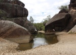
Visit Cranky Rock, New South Wales, Australia
Between Warialda and Inverell on the Gwydir Highway is Cranky Rock. According to local legend, in the 1800s a Chinese man jumped off Cranky Rock into the creek while being pursued by the local police. Cranky Rock is now a popular picnic spot. -
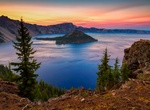
Explore Crater Lake National Park, Oregon
Crater Lake National Park is a United States National Park located in southern Oregon, whose primary feature is Crater Lake. This National Park was established on May 22, 1902, and it is the sixth oldest National Park in the U.S. This park encompasses the Crater Lake caldera, which rests in the remains of a destroyed volcano (eventually named Mount Mazama) and the sur...