Give us feedback!

Our philosophy is simple. We want to encourage you to dream. BIG! Then we help you plan your trip, get the most out of it while you're traveling and help you share your experience with friends.
Join Now It's FREE
Dreams Still To Do
Checked-Off Dreams
Dreams Still To Do
Checked-Off Dreams
Advertisement
Explore Landmarks (Natural)
-
Visit Devil's Ashpit & NASA Tracking Station, Ascension Island, St. Helena
The Devil's Ashpit is a hill of 1,759 feet on the east side of Ascension Island, right next to the NASA Tracking Station. The former NASA Tracking Station was part of the NASA Spaceflight Tracking and Data Network, an integrated Apollo and deep-space station (DSS 72) was constructed in 1965. There being no ongoing need for the station, most of it (including all the a... -
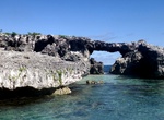
See Devil's Bridge, Antigua
Devil's Bridge is a natural rock arch in eastern Antigua located on the Atlantic coast near Indian Town Point to the east of Willikies. The area around the arch features several natural blowholes which shoot up water and spray powered by waves from the Atlantic Ocean. Nearby popular local swimming spots such as Long Cove are sheltered by an offshore reef acts as a na... -
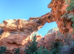
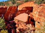
Hike Devil's Bridge Trail, Sedona, Arizona
Devil's Bridge is the largest natural sandstone arch in the Sedona area. The trailhead elevation of 4,600 feet, there's a mere 400 foot climb in altitude during this moderately difficult, 1.8-mile roundtrip trek. After you've walked about three-quarters of a mile from the parking area, the trail will divide. Head down the path to the left and you'll end up at the bas... -
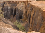
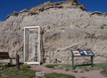
See Devil's Corkscrew, Agate Fossil Beds National Monument, Nebraska
At Agate Fossil Beds National Monument near the town of Harrison, Nebraska, visitors can view in the outcropping a curious spiral-shaped fossil called Daimonelix, also known as Devil's Corkscrew. "Devil's corkscrews," Miocene-age burrows of Palaeocastor was discovered in the late 19th century. -
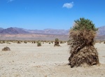
See Devil's Cornfield, Death Valley National Park, California
On both sides of Hwy 190 just east of the dunes in Death Valley you will find the Devil's Cornfield. It derives its name from a species of arroweed whose former roots have been exposed as the ground subsided around them. Abundant ground water just below the surface keeps the arroweed thriving here in the midst of extraordinarily harsh conditions. -
See Devil's Dining Room (Devil's Kitchen), Sedona, Arizona
At 0.6 miles on the Broken Arrow Trail, look for the fence around Devil's Dining Room Sinkhole 100 feet to the left and downhill. Also known as the Devil's Kitchen. -
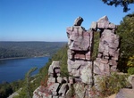
See Devil's Doorway, Devil's Lake State Park, Wisconsin
Devil's Doorway (Devil's Gateway) is a rock formation in Devil's Lake State Park. -
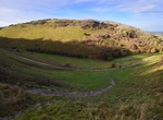
Visit Devil's Dyke, South Downs, Sussex, England
Devil's Dyke is a 100m deep V-shaped dry valley on the South Downs in Sussex in southern England, 5 miles (8.0 km) north-west of Brighton. It is managed by the National Trust, and is also part of the Beeding Hill to Newtimber Hill Site of Special Scientific Interest. Devil's Dyke was a major local tourist attraction in the late 19th and early 20th centuries. It is now... -
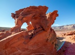
See Devil's Fire Heart, Little Finland, Nevada
Devil's Fire Heart is one of the rock formation in Little Finland in Gold Butte National Monument, Nevada. -
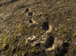
See Devil's Footprints (Ciampate del Diavolo), Campania, Italy
The Ciampate del Diavolo ("Devil's Footprints" or "Devil's Trails") is a locality near the extinct Roccamonfina volcano in northern Campania, Italy. It is named after fossilised footprints preserved in pyroclastic flow deposits that have been dated to around 350,000 years ago. They have been attributed to bipedal ... -
Explore Devil's Garden, Arches National Park, Utah
Devil's Garden is an area of Arches National Park, located near Moab, Utah, that features a series of rock fins that have broken out of the earth due to erosion and produce many spectacular views. The Devil's Garden Trail that travels throughout Devil's Garden is just over 7 miles (11 km) long and leads to the Tunnel Arch, Pine Tree Arch, Landscape Arch, Partition Arc... -
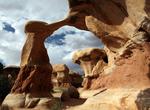
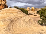
Hike Devil's Garden, Grand Staircase-Escalante National Monument, Utah
The Devil's Garden of the Grand Staircase-Escalante National Monument (GSENM) in south central Utah, the United States, is a natural desert area measuring 640 acres (one square mile or approximately 2.59 km2) that features hoodoos, natural arches and other geologic formations composed of sandstone. On the Hole-in-the-Rock Road 13 miles south from Highway 12, turn righ... -
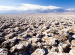
Visit Devil's Golf Course, Death Valley National Park
The Devil's Golf Course is a large salt pan on the floor of Death Valley, located in the Mojave Desert within Death Valley National Park. The park is in eastern California. It was named after a line in the 1934 National Park Service guide book to Death Valley National Monument, which stated that "Only the devil could play golf" on its surface, due to a rough texture f... -
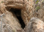
See Devils Hole, Death Valley National Park
The Devils Hole spring, a unique desert pupfish habitat is administered by Death Valley National Park, and located within the Ash Meadows National Wildlife Refuge, in Nye County, Nevada Southwestern United States. Devils Hole is a geothermal (92 °F or 33 °C), aquifer-fed pool within a limestone cavern in the Amargosa Desert in the Amargosa Valley of Nevada, ea... -
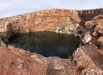
Visit Devil's Inkwell Cenote, Bottomless Lakes State Park, New Mexico
Devil's Inkwell is the smallest lake with a surface area of 0.36 acres (0.15 ha). Its name stems from the water's dark color, caused by the steep sides of the cenote and algae growth within the lake. In the winter, Devil's Inkwell and Cottonwood Lake are both stocked with Rainbow Trout. It's 28.2 feet (8.6 m) deep.