Give us feedback!

Our philosophy is simple. We want to encourage you to dream. BIG! Then we help you plan your trip, get the most out of it while you're traveling and help you share your experience with friends.
Join Now It's FREE
Dreams Still To Do
Checked-Off Dreams
Dreams Still To Do
Checked-Off Dreams
Advertisement
Explore Landmarks (Natural)
-
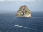
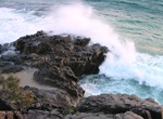
Dive Diamond Rock (Rocher du Diamant), Martinique
Diamond Rock (Rocher du Diamant) is a 175 m (574 feet) highbasalt island located south of Fort-de-France, the main port of the Caribbean island of Martinique. The uninhabited island is about 3 kilometers (1.9 mi) from Pointe Diamant. The island gets its name from the reflections that its sides cast at certain hours of the day, which evoke images of a precious stone. I... -
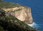
View Dingli Cliffs, Malta
Scenic, towering cliffs featuring panoramic views & a chapel, which marks the area's highest point. -
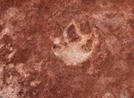
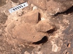
Hike to Dino Cliffs Dinosaur Tracks, Washington, Utah
Dino Cliffs Dinosaur Tracks is a great, short hiking trail for families of all ages! The first part of the trail is a little bit sandy, but doesn’t last too long. At the bottom out on the trail a slate rock surface in part of the stream bed to the left of the trail. In the hardened sedimentary rock you can find 17 well preserved dino tracks presumed to be from G... -
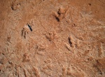
Hike to Dinosaur Dance Floor (Dinosaur Trackway), North Coyote Buttes, Arizona
The dinosaur trackway within the area is a site of 0.75 acres (3,000 m2) that has densely packed dinosaur footprints within the area. The trackway contains more than 1,000 footprints which were made approximately 190 million years ago. Tracks of three genera of Eubrontes, Anchisauripus and Grallator are present along with a Sauropodomorph that has not been identified.... -
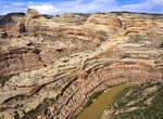
Explore Dinosaur National Monument, Colorado & Utah
Dinosaur National Monument is a National Monument located on the southeast flank of the Uinta Mountains on the border between Colorado and Utah at the confluence of the Green and Yampa Rivers. Although most of the monument area is in Moffat County, Colorado, the Dinosaur Quarry is located in Utah just to the north of the town of Jensen, Utah. The nearest communities a... -
Hike to Dinosaur Stomping Grounds, Moab, Utah
A gradual up-hill hike to the tracks (3 miles round trip). The trail parallels a mountain bike trail for a short distance before branching off on its own. Follow the rock cairns and trail to the dinosaur tracks. From Moab, go north on Highway 191 for 23 miles. Turn right 3/4 mile past milepost 148. Cross the railroad tracks and follow the main road for 1 mile. Take... -
Explore Diomede Islands, Russia & United States
The Diomede Islands (/ˌdaɪ.əˈmiːdiː/; Russian: острова́ Диоми́да, romanized: ostrová Diomída), also known in Russia as Gvozdev Islands (Russian: острова́ Гво́здева, romanized: ostrová Gvozdjeva), consist of two rocky, mesa-like islands: The Russian island of Big Diomede (part of Chukotka Autonomous Okrug), also known as The Diomede Islands are loc... -
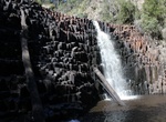
Hike to Dip Falls & Big Tree, Tasmania, Australia
The Dip Falls, a cascade waterfall over cubic-basalt formed rocks on the Dip River, is located in the North West region of Tasmania, Australia. The waterfall is situated in the Dip Range Regional Reserve at an elevation of 218 metres (715 ft) above sea level and descends in the range of 22–34 metres (72–112 ft), near the village of Sisters Beach and approx... -
Explore Dip River Forest Reserve, Tasmania, Australia
Dip River Forest Reserve is located on the North West Coast of Tasmania southeast of Stanley via the Bass Highway. -
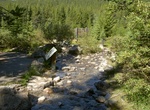
Hike to Divide Creek, British Columbia/Alberta, Canada
Divide Creek is a short creek near Kicking Horse Pass on the British Columbia/Alberta border (also the border between Yoho National Park and Banff National Park). After following the Continental Divide of the Americas for a short distance, the creek forks, with one side draining through the Bow River east to Hudson Bay and the Arctic Ocean, and the other side draining... -
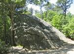
See Doane Rock, Cape Cod, Massachusetts
Doane Rock is a glacial erratic located in Eastham, Massachusetts on the grounds of the Cape Cod National Seashore. It is the largest exposed boulder on Cape Cod. It stands 18 feet (5.5 m) high and extends below the ground an estimated 12 feet (3.7 m). This boulder is named after Deacon John Doane, one of Eastham's original settlers. It has also been called Enochs or ... -
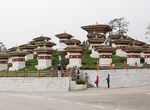
Visit Dochula Pass, Bhutan
The Dochu La is a mountain pass in the snow covered Himalayas within Bhutan on the road from Thimphu to Punakha where 108 memorial chortens or stupas known as "Druk Wangyal Chortens" have been built by Ashi Dorji Wangmo Wangchuk, the eldest Queen Mother. Apart from the chortens there is a monastery called the Druk Wangyal Lhakhang (temple), built in honour of the four... -
See Dodiongan Falls, Mindanao Island, Philippines
Dodiongan Falls is a 20-metre (65.5 ft) high waterfall located in Barangay Bonbonon, 14 km away from Iligan City in Lanao del Norte province of the Philippines. -
Explore Doi Inthanon National Park, Chiang Mai Province, Thailand
Doi Inthanon National Park nicknamed "the roof of Thailand", is in the Thanon Thong Chai Range, Chom Thong District, Chiang Mai Province, northern Thailand. It includes Doi Inthanon, the country's highest mountain. Established in 1972, it is 482 square kilometres (186 sq mi) in size. The park is approximately 60 kilometres (37 mi) from Chiang Mai. It includes Karen an... -
Hike to Dolphin Point Lookout, Noosa National Park, Queensland
Dolphin Point Lookout is located along the Noosa Coastal Track in Noosa National Park, Queensland.