Give us feedback!

Our philosophy is simple. We want to encourage you to dream. BIG! Then we help you plan your trip, get the most out of it while you're traveling and help you share your experience with friends.
Join Now It's FREE
Dreams Still To Do
Checked-Off Dreams
Dreams Still To Do
Checked-Off Dreams
Advertisement
Explore Landmarks (Natural)
-
Kayak Emerald Cave (Black Canyon), Arizona
A kayak to Emerald Cave is a great way to take in some of the top-rated sites of Lake Mead National Recreation Area! Kayak two miles upstream on the Colorado River through the dramatic Black Canyon, the first national water trail in the Southwest, to magical Emerald Cave. Visitors can rent a kayak from the Willow Beach Marina, or launch their own boat, kayak, or canoe... -
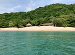
Explore Emerald Coast, Nicaragua
Nicaragua's Emerald Coast can be accessed via the new Carretera Costanera, a 350km-long highway linking 53 beaches along the Nicaragua's Pacific Coast. It goes from the Gulf of Fonseca in the north to the turquoise waters of Playa El Naranjo in the south. -
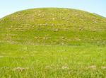
Visit Emerald Mound Site, Mississippi
The Emerald Mound Site (22 AD 504), also known as the Selzertown site, is a Plaquemine culture Mississippian period archaeological site located on the Natchez Trace Parkway near Stanton, Mississippi, United States. The site dates from the period between 1200 and 1730 CE. It is the type site for the Emerald Phase (1500 to 1680 CE) of the Natchez Bluffs Plaquemine cultu... -
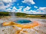
See Emerald Pool (Black Sand Basin), Yellowstone National Park, Wyoming
Emerald Pool 154.6 °F (68.1 °C) is located at Black Sand Basin in Yellowstone National Park. Black Sand Basin was originally called the Emerald Group, a name given to it by A. C. Peale in 1878 but tourists started calling it Black Sand Basin and that name stuck. The main draw of the basin used to be "Handkerchief Pool", people would drop a handkerchief in the... -
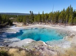
See Emerald Spring (Norris Geyser Basin), Yellowstone National Park, Wyoming
Emerald Spring is located at Norris Geyser Basin, Yellowstone National Park. -
Explore Engadin (Engadine) Valley, Switzerland
The Engadin or Engadine is a long high Alpine valley region in the eastern Swiss Alps located in the canton of Graubünden in most southeastern Switzerland with about 25,000 inhabitants. It follows the route of the Inn (Romansh:En) from its headwaters at Maloja Pass in the southwest running roughly northeast until the Inn flows into Austria, one hundred kilometers... -
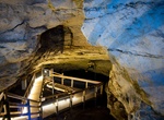
Explore Engelbrecht Cave, SA, Australia
Engelbrecht Cave (also known as North Terrace Cave, Vansittarts Cave and 5L19 & 5L20) is a cave system in the Australian state of South Australia consisting of a sinkhole with two major passages located under the Mount Gambier urban area. It is owned by the local government area of City of Mount Gambier and has been developed as a tourism venue. Its dry extent is ... -
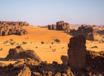
Explore Ennedi Massif, Chad (UNESCO Site)
The Ennedi Plateau, located in the North-East of Chad, in the Ennedi Region, is a sandstone bulwark in the middle of the Sahara. It is assailed by the sands on all sides, that encroach the deep valleys of the Ennedi. Only the caravans manage to cross it and this makes the region an area subject to multiple influences. The landscape has structures like towers, pillars,... -
Visit Enoturismo Cartuxa, Evora, Portugal
Enoturismo Cartuxa is a large piece of land where the grapes are grown. They are used to produce wine that is one of the best ones in the area. In Cartuxa you can try it and enjoy being in a very pleasant place. -
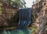
Visit Epta Piges (Seven Springs), Rhodes, Greece
Epta Piges (Seven Springs) has a tunnel and waterfall. The springs themselves were not much but the pitch black tunnel is a nice experience. -
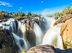
See Epupa Falls, Angola & Namibia
Epupa Falls (also known as Monte Negro Falls in Angola) is a series of large waterfalls created by the Cunene River on the border of Angola and Namibia, in the Kaokoland area of the Kunene Region. The river is about 0.5 kilometres (1,600 ft) wide in this area and drops in a series of waterfalls across a length of 1.5 kilometres (0.93 mi), with the greatest single drop... -
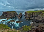
Visit Eshaness Cliffs, Shetland Archipelago, Scotland
Esha Ness, also spelled Eshaness, is a peninsula on the west coast of Northmavine, on the island of Mainland, Shetland, Scotland. Esha Ness Lighthouse on the west coast, just south of Calder's Geo. It was designed by David Alan Stevenson and commissioned in 1929. The hamlet of Tangwick contains the Tangwick Haa Museum, which opened in the former Laird's house in 1987.... -
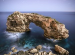
Rock Climb Es Pontàs, Mallorca
Es Pontàs is a natural arch in the southeastern part of the island of Mallorca. Es Pontàs was shown in the film King Lines showing Chris Sharma's first ascent of the hardest deep water solo (9b) climb in the world. The arch is located on the coastline between the Cala Santanyí and Cala Llombards in the municipality of Santanyí. -
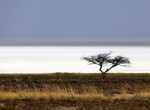
Explore Etosha Pan, Etosha National Park, Namibia
The Etosha pan is a large endorheic salt pan, forming part of the Kalahari Basin in the north of Namibia. The 120-kilometre-long (75-mile-long) dry lakebed and its surroundings are protected as Etosha National Park, one of Namibia's largest wildlife parks. The pan is mostly dry but after a heavy rain it will acquire a thin layer of water, which is heavily salted by th... -
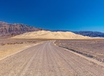
Off-road to Eureka Valley Sand Dunes, Death Valley National Park, California
The Eureka Valley Sand Dunes are located in the southern part of Eureka Valley, in northern Inyo County in eastern California, in the southwestern United States. Although covering an area of only 3 square miles (8 km²), the dunes rise approximately 680 feet (207 m) above the surrounding valley floor, making them one of the highest dune fields in North America. Hi...