Give us feedback!

Our philosophy is simple. We want to encourage you to dream. BIG! Then we help you plan your trip, get the most out of it while you're traveling and help you share your experience with friends.
Join Now It's FREE
Dreams Still To Do
Checked-Off Dreams
Dreams Still To Do
Checked-Off Dreams
Advertisement
Explore Landmarks (Natural)
-
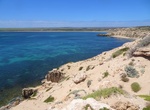
Dive Ewens Ponds, South Australia
Ewens Ponds is a series of three water-filled limestone sinkholes in the state of South Australia located in the gazetted locality of Eight Mile Creek, on the watercourse of Eight Mile Creek about 25 kilometres (16 miles) south of Mount Gambier and 8.4 kilometres (5.2 miles) east of Port MacDonnell. The ponds are popular with recreational divers due to their excellent... -
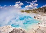
See Excelsior Geyser Crater, Yellowstone National Park, Wyoming
Excelsior Geyser Crater, formerly known as Excelsior Geyser, is a hot spring in the Midway Geyser Basin of Yellowstone National Park in the United States. Excelsior was named by the Hayden Geological Survey of 1871. Possibly the only known photograph of Excelsior in full eruption was taken by Frank Jay Haynes in 1888. The Excelsior Geyser pool discharges 4,000 to 4,50... -
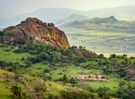
Visit Externsteine Rock Formation, Germany
The Externsteine are a distinctive rock formation located in Ostwestfalen-Lippe of northwestern Germany, not far from the city of Detmold at Horn-Bad Meinberg. The formation is a tor consisting of several tall, narrow columns of rock which rise abruptly from the surrounding wooded hills. The name probably means "stones of the Egge",Eggemeaning ridge. The Externsteine ... -
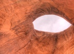
See Eye of the Sun (Suns Eye) Arch, Monument Valley, Arizona
Suns Eye is a pothole natural arch located within the boundaries of Monument Valley Navajo Tribal Park. A Navajo guide is required for any visitation. -
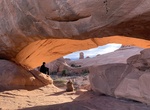
See Eye of the Whale Arch, Arches National Park
Eye of the Whale Arch is located Herdina Park section of Arches National Park. It has a span of 37 feet, a height of 12 feet, a thickness of 25 feet, and a width of 41 feet. This is an Arch very few will see, as it’s on a sand and dirt road called Willow Springs Road, and very hard to traverse in a vehicle without proper ground clearance or four wheel drive. Fur... -
Explore Eyre Peninsula, South Australia
The Eyre Peninsula is a triangular peninsula in South Australia. It is bounded by the Spencer Gulf on the east, the Great Australian Bight on the west, and the Gawler Ranges to the north. Earlier called Eyre's Peninsula, it was named after explorer Edward John Eyre, who explored parts of the peninsula in 1839–41. The coastline was first charted by the expedition... -
Visit Ezulwini Valley, Eswatini
Ezulwini Valley is a valley of northwest Eswatini. Also known as "The Valley of Heaven", the valley lasts for about 30 kilometres, and is bounded to the east by the Mdzimba hills. The historical capital of Eswatini Lobamba is located in the valley, also known as the Royal Valley, a place of many legends of Swazi history. The main highway is the MR3 road; some parts ha... -
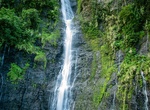
Hike to Faarumai Waterfall, Tahiti, French Polynesia
Take the hike leading to Faarumai Waterfall. -
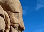
See Face Rock, Joshua Tree National Park, California
Face Rock is a short side trip between the Discovery Loop Trail and the Split Rock Loop Trail in Joshua Tree National Park. -
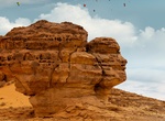
See Face Rock (Al-'Ula), Saudi Arabia
Face Rock is amongst the monumental tombs of Hegra, next to Jabal AlAhmar. As with all of AlUla’s rock formations, sunrise and sunset are prime times to visit. -
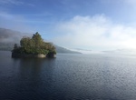
Visit Factor's Island, Loch Katrine, Scotland
Factor's Island (Eilean a' Bhàillidh) is on Loch Katrine and where Rob Roy once imprisoned the Duke's factor. -
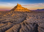
Off-road to Factory Butte, Caineville, Utah
Factory Butte in Wayne County, Utah is a 6,302-foot (1,921 m) summit in the Upper Blue Hills in northern Wayne County, Utah, United States, about 12 miles (19 km) northwest of Hanksville and about 14 miles (23 km) east of Capitol Reef National Park boundary. The butte was so named by early settlers who thought its outline resembled a huge factory building, the Provo w... -
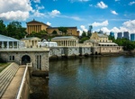
See Fairmount Water Works, Philadelphia, Pennsylvania
The Fairmount Water Works in Philadelphia, Pennsylvania was Philadelphia's second municipal waterworks. Designed in 1812 by Frederick Graff and built between 1812 and 1872, it operated until 1909, winning praise for its design and becoming a popular tourist attraction. It now houses a restaurant and an interpretive center that explains the waterworks' purpose and loca... -
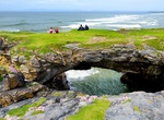
See Fairy Bridges, Bundoran, Ireland
Fairy Bridges – sea stacks hundreds of years old and Bundoran’s original tourist attraction back in the 1800s. However, it is believed that as far back as the 1700s locals thought these to be haunted by the fairies with the result of the name “The Fairy Bridges”. -
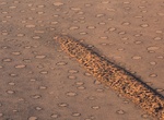
See Fairy Circles, Namibia
Fairy Circles are circular patches of land void of plants, each between 2m and 15m in diameter, arranged in a honeycomb-like pattern. Across the arid grasslands of the Namib Desert lies millions of Fairy Circles across 2,500km of land.