Give us feedback!

Our philosophy is simple. We want to encourage you to dream. BIG! Then we help you plan your trip, get the most out of it while you're traveling and help you share your experience with friends.
Join Now It's FREE
Dreams Still To Do
Checked-Off Dreams
Dreams Still To Do
Checked-Off Dreams
Advertisement
Explore Landmarks (Natural)
-
See Firehole Spring, Yellowstone National Park, Wyoming
Firehole Spring is located in the Lower Geyser Basin of Yellowstone National Park. -
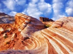
Hike to Fire Wave, Valley of Fire State Park, Nevada
Take this short, accessible trail to get to one of the most stunning sandstone formations in the park: the fire wave. An easy 1.25-mile roundtrip trail winds through the reds and oranges of Aztec sandstone. To preserve this fragile and unique area, please stay on the trail, and do not walk on the wave formation at the end of the trail. Distance: 1.25 miles round-tri... -
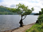
Visit Firkin Point, Loch Lomond, Scotland
Firkin Pointis on the west bank of Loch Lomond about halfway between Inverbeg and Tarbet on the A82. -
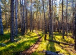
Visit Fiscalini Ranch Preserve, San Luis Obispo County, California
Serene preserve with pine forests, fields & oceanside bluffs featuring walking trails & wildlife. -
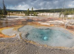
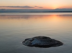
See Fishing Cone, Yellowstone National Park
Fishing Cone is a geyser in the West Thumb Geyser Basin of Yellowstone National Park in the United States. In the earlier part of the 20th century, this cone had eruptions as high as 40 feet (12 m). As the water level in Yellowstone Lake has increased, the cone is now inundated during the spring and the temperatures in the cone have cooled enough that it no longer eru... -
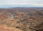
Explore Fish River Canyon, Namibia
The Fish River Canyon is located in the south of Namibia. It is the second largest canyon in the world and the largest in Africa, as well as the second most visited tourist attraction in Namibia. It features a gigantic ravine, in total about 100 miles (160 km) long, up to 27 km wide and in places almost 550 metres deep. The Fish River is the longest interior river in ... -
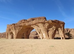
See Five Arch Rock (Ennedi Massif), Chad
Five Arch Rock is a sandstone feature of the Ennedi Mountains in Chad, Central Africa. -
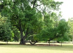
See Five-Dollar Tree (Tembusu Heritage Tree), Singapore Botanic Gardens, Singapore
The tree is pictured on the back of the Singaporean five-dollar bill, and is one of the Heritage trees in Singapore. It has a unique lower lateral branch, which makes it easily recognisable. Located in Lawn E of the Singapore Botanic Gardens. The tree is estimated to be over 180 years old. -
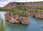
See Five Finger Rapids, Yukon River, Yukon, Canada
The Five Finger Rapids, also known as the Five Fingers, are located on the Yukon River, Yukon, Canada. Four islands of composite rock divide the river into five narrow channels of which only the eastern is passable. Indigenous Canadians called the Five Finger Rapids "Tthi-cho Nadezhe," or "big rocks standing up." The Five Finger Rapids were a common obstacle for gold ... -
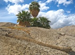
Visit Five Palm Oasis, Anza-Borrego Desert State Park, California
Five Palm Oasis is just off the Arroyo Salado Trail in Anza-Borrego Desert State Park, California. -
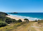
Visit Five Rocks Beach, Byfield National Park, Queensland, Australia
Five Rocks camping area is surrounded by coastal woodland with access to a vehicle-free beach. Explore rugged headlands or fish, swim and surf. Access: the camping area can only be reached by 4WDs with high clearance. It is accessible for off-road camper trailers—track and weather conditions permitting. Read about road and track conditions. Number of sites: 12... -
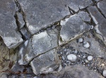
Visit Flaggy Shore, Ireland
Flaggy Shore is one of nine sites of geological importance that form the basis of the Burren and Cliffs of Moher Geopark. Famous for its limestone pavements, fossils embedded in the rock, including sculptured rocks along the shore called ‘Biokarst’. -
Visit Flat Point Tide Pools, Saba Island
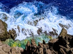
The Flat Point Tide Pools (or Saba Tide Pools) are located on the coast of Saba, in the Dutch Caribbean. They are located on the Flat Point peninsula Lower Hell's Gate. These tide pools feature large lava rock formations filled with colorful saltwater pools. The site was formed during volcanic activity about 5,000 years ago. A large lava flow went down the northeast s... -
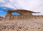
See Flat Top Arch (Sliver Arch), Bisti Badlands, New Mexico
Flat Top Arch (aka Sliver Arch)is located in the Bisti Badlands, New Mexico. -
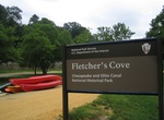
Visit Fletcher's Cove, Washington, D.C.
Fletcher's Cove is a park and recreation area owned and managed by National Park Service, located at 4940 Canal Road, Washington, D.C. 20007, between Chain and Key Bridges, part of Chesapeake and Ohio Canal National Historical Park. Fletcher's Cove has been in this location since the 1850s and is renowned as a fishing and recreational area. The nearby Abner Cloud Hous...