Give us feedback!


 See all

Our philosophy is simple. We want to encourage you to dream. BIG! Then we help you plan your trip, get the most out of it while you're traveling and help you share your experience with friends.
Join Now It's FREE
Dream Packages
Duration: 3 hours
Price: $118.81
Price: $118.81
Duration: 3 hours
Price: $131.66
Price: $131.66
Duration: 2 days
Price: $398.24
Price: $398.24
Duration: 5 days
Price: $726.42
Price: $726.42
Dreams Still To Do
Checked-Off Dreams
Dreams Still To Do
Checked-Off Dreams
Advertisement
Explore Man-Made Sites
-
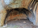
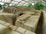
Visit Bunjil's Shelter, Stawell, Victoria, Australia
Bunjil's Shelter, also known as Bunjil's Cave, is an Aboriginal sacred site in the Grampians region of Australia near Stawell. It contains a painting of Bunjil and two dingos or dogs. It is the only known rock art site to represent Bunjil, the creator-being in many Koori cultures. It is one of the most significant Aboriginal cultural sites in south-eastern Australia. ... -
Visit Bunk'Art 2, Tirana, Albania
Unique Albanian history museum inside a preserved, Communist-era nuclear pit bunker. -
Visit Bunker Hill (Hill 400), Unalaska, Alaska
Two months after the bombing of Fort Mears, Navy Seabees began constructing a defense installation on Hill 400. Also called Bunker Hill and Little South America (for its geographic shape), Hill 400 overlooks Unalaska Bay, Iliuliuk Harbor, and Captains Bay. This trategic location provided an ideal coastal defense site. Panama mounts for 155-mm guns were installed at th... -
Visit Bunker Hill Monument, Charlestown, Massachusetts
The Bunker Hill Monument was built to commemorate the Battle of Bunker Hill. The 221 foot (67 m) granite obelisk was erected between 1827 and 1843 in Charlestown, Massachusetts, with granite from Quincy, Massachusetts, conveyed to the site via the Granite Railway, built specially for that purpose, followed by a trip by barge. There are 294 steps to the top. The Bunker... -
Climb Bunker Hill Steps, Los Angeles, California
Historical landmark in Los Angeles, California -
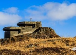
See Bunker Mules, Blåvand, Denmark
Bunker Mules is once of the WWII bunkers in Blåvand that has been converted to an art project. During the Second World War, Hitler had grand plans for hisAtlantikwall, or Atlantic Wall. However, the project was never completed and ultimately abandoned. When it was built, the wall stretched along the western coasts of Norway, Denmark, Germany, Holland, Belgium,... -
Visit Bunker of Colonel de Castries, Dien Bien Phu, Vietnam
The recreated command bunker of Colonel Christian de Castries has been recreated on the west of the Ron River. -
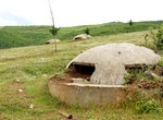
See Bunkers in Albania, Albania
Concrete military bunkers are a ubiquitous sight in Albania, with an average of 5.7 bunkers for every square kilometer (14.7 per square mile). The bunkers (Albanian:bunkerët) were built during the Hoxhaist government led by the Leader Enver Hoxha from the 1960s to the 1980s, as the regime fortified Albania by building more than 750,000 bunkers. Hoxha's program of... -
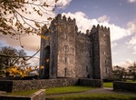
Visit Bunratty Castle, Ireland
Bunratty Castle is a large tower house in County Clare, Ireland. It lies in the centre of Bunratty village, by the N18 road between Limerick and Ennis, near Shannon Town and its airport. The name Bunratty, Bun Raite in Irish, means the 'bottom' or end of the 'Ratty' river. This river, alongside the castle, flows into the nearby Shannon estuary. From the top of the cas... -
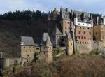
Visit Burg Eltz Castle, Germany
Burg Eltz is a medieval castle nestled in the hills above the Moselle River between Koblenz and Trier, Germany. It is still owned by a branch of the same family that lived there in the 12th century, 33 generations ago. The Rübenach and Rodendorf families' homes in the castle are open to the public, while the Kempenich branch of the family uses the other third of ... -
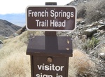
Off-road to Burgess Mine (French Spring Trail), Inyo Mountain Wilderness Area, California
The Burgess Mine Trail is located in the Inyo Mountain Wilderness Area. This 8.0-mile long trail starts at 4,600 feet at the end of the French Spring Road in Owens Valley. -
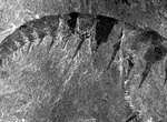
Explore Burgess Shale Fossil Beds, Yoho National Park, Canada
The Burgess Shale Formation is a fossil field in the Canadian Rockies of British Columbia, Canada. It is famous for the exceptional preservation of the soft parts of its fossils. At 508 million years (Middle Cambrian) old, it is one of the earliest fossil beds containing soft-part imprints. The rock unit is a black shale and crops out at a number of localities near th... -
See Burgos Cathedral, Spain (UNESCO site)
The Burgos Cathedral (Spanish: Catedral de Burgos) is a Gothic-style Roman Catholic cathedral in Burgos, Spain. It is dedicated to the Virgin Mary and is famous for its vast size and unique architecture. Its construction began in 1221, and was in use nine years later, although work continued on and off for two hundred years. It was primarily influenced by the French G... -
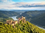
Visit Burgruine Aggstein, Austria
The ruins of Aggstein are the remnants of a castle on the right bank of the Danube in Wachau whose origins go back to the 12th century. The castle ruins are situated at about 300 meters (ca. 985 feet ) altitude above the right bank of the Danube on an outcropping that runs in an East-West direction. It is some 150 meters (ca. 460 feet) long and has a rock structure at... -
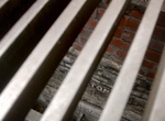
See Buried Remains of Little Compton Street, London, England
Look for an anonymous-looking traffic island in the middle of London’s busy Charing Cross Road. Then look down the metal grate covering the island you will see two tiled, Victorian street names set into the wall. Bearing the faded name of Little Compton Street, it is a beguiling glimpse into a long lost road buried underneath the modern day streets of London.


Price: $104.91