Give us feedback!


 See all

Our philosophy is simple. We want to encourage you to dream. BIG! Then we help you plan your trip, get the most out of it while you're traveling and help you share your experience with friends.
Join Now It's FREE
Dream Packages
Duration: 12 hours 30 minutes
Price: $104.91
Price: $104.91
Duration: 11 hours
Price: $208.42
Price: $208.42
Duration: 9 hours
Price: $88.47
Price: $88.47
Duration: 4 days
Price: $663.61
Price: $663.61
Dreams Still To Do
Checked-Off Dreams
Dreams Still To Do
Checked-Off Dreams
Advertisement
Explore Man-Made Sites
-
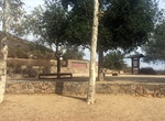
Visit Cowles Mountain Staging Area, Mission Trails Regional Park, California
Cowles Mountain Staging Area is located at the corner of Navajo Rd and Golfcrest Dr on the western side of Cowles Mountain in Mission Trails Regional Park. The gates to this park entrance are open 8:00 a.m. to 5:00 p.m. from November 1 through March 31, and 8:00 a.m. to 7:00 p.m. from April 1 through October 31. -
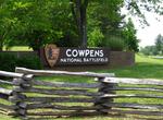
Visit Cowpens National Battlefield, South Carolina
Cowpens National Battlefield or Cowpens National Battlefield Park is a unit of the National Park Service just east of Chesnee, South Carolina, not far from the North Carolina state line. Brigadier General Daniel Morgan won the Battle of Cowpens, a decisive Revolutionary War victory, here over British Lieutenant Colonel Banastre Tarleton on January 17, 1781.It is consi... -
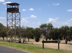
Visit Cowra Prisoner of War (POW) Camp, Cowra, New South Wales, Australia
During World War II, Cowra was the site of a prisoner of war (POW) camp. Most of the detainees were captured Japanese and Italian military personnel. However, in July 1942, Indonesian political prisoners from the Dutch Tanahmerah prison on the Digul river, in West Papua, were transported as "prisoners-of-war" to the Cowra prison camp, at the behest of Netherlands East... -
Visit Cow's Gate, Gdańsk, Poland
Built in 1378, this gate is one of the oldest structures in Gdansk. Cows used to pass the gate, hence the name. -
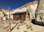
Visit Cow Springs Trading Post, Arizona
Cow Springs a graffiti-covered ruins of an abandoned trading post in the middle of Navajo Nation. It has an estimated elevation of 5,863 feet (1,787 m) above sea level. -
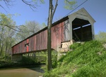
See Cox Ford Covered Bridge, Indiana
The Cox Ford Covered Bridge crosses Sugar Creek along the west edge of Turkey Run State Park, Parke County, Indiana. This single span Burr Arch truss structure has a length of 176 feet (54 m), or 192 feet (59 m) including the 8 feet (2.4 m) overhang at each end, with a portal clearance 16 feet (4.9 m) wide by 13 feet (4.0 m) in height. Built in 1913 by Joseph A. Britt... -
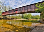
See Cox Ford Covered Bridge, Indiana
The Cox Ford Covered Bridge crosses Sugar Creek along the west edge of Turkey Run State Park, Parke County. This single span Burr Arch truss structure has a length of 176 feet, or 192 feet including the 8-foot overhang at each end, with a portal clearance 16 feet wide by 13 feet in height. Built in 1913 by Joseph A. Britton, the Cox Ford Covered Bridge has a rather un... -
Off-road to Coyote Creek Cabin, Utah
Coyote Creek Cabin is located where BLM 7040 and 7045 meet in southern Utah. -
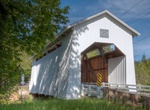
Cross Coyote Creek Covered Bridge, Oregon
The Coyote Creek Bridge near Crow, Oregon, United States, is listed on the National Register of Historic Places. The 60-foot (18 m) Howe truss structure, built in 1922, carries Battle Creek Road over Coyote Creek. -
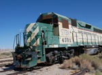
See Coyote Wells Trains, California
Coyote Wells is an unincorporated community in Imperial County, California. It is located on the San Diego and Arizona Eastern Railway (Impossible Railroad line) 24 miles (39 km) west of El Centro, at an elevation of 299 feet (91 m). On an unused stretch of track that is the eastern end of the old Desert Line. The owners of Pacific Imperial Railroad (PIR) took $450,00... -
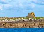
See Crab Island Ruins, Doolin, Ireland
The ruins of a 19th century police post on the small Crab Island are within walking distance of Doolin harbor. -
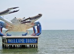
See Crab Monument, Kep, Cambodia
The Crab Monument is offshore the Kep beach. It looks nice when you ride along the road and see this giant with welcoming gesture. -
See Crabs of Cleopatra’s Needle (Central Park), NYC, New York
Cleopatra's Needle is the popular name for each of a pair of ancient Egyptian obelisks re-erected in London and New York City in 1877 and 1881 respectively. The removal of the obelisks from Egypt was presided over by Isma'il Pasha, who had greatly indebted the Khedivate of Egypt during its rapid modernization. The London and New York needles were originally made in He... -
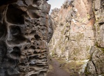
Hike Crack in the Ground, Oregon
Over time, earthquakes and volcanos have split and splintered the earth’s surface. Such shocks to the system are not uncommon over the span of six billion years. But still, they have caused many cracks and blisters in the ground. So…why doesn’t more of our earth look like the Grand Canyon, if not “Land of the Lost?” Rock rubble, along w... -
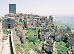
Visit Craco, Italy
Craco is a medieval village located in the Region of Basilicata and the Province of Matera in Italy. During the mid-twentieth century, recurring earthquakes began to take a toll on the viability of the town. Between 1959 and 1972, portions of the village were severely damaged and rendered uninhabitable by a series of frana, or landslides. The geological threat to the ...

Price: $160.26