Give us feedback!


 See all

Our philosophy is simple. We want to encourage you to dream. BIG! Then we help you plan your trip, get the most out of it while you're traveling and help you share your experience with friends.
Join Now It's FREE
Dream Packages
Duration: 11 hours
Price: $208.42
Price: $208.42
Duration: 1 hour 30 minutes
Price: $116.91
Price: $116.91
Duration: 12 hours
Price: $124.49
Price: $124.49
Duration: 4 days
Price: $785.33
Price: $785.33
Dreams Still To Do
Checked-Off Dreams
Dreams Still To Do
Checked-Off Dreams
Advertisement
Explore Man-Made Sites
-
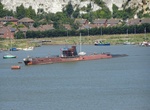
See Submarine U-475 Black Widow (Foxtrot B-49), Strood, England
Submarine U-475 Black Widow was a Soviet Navy submarine of the Cold war period, which is now in private hands. It is currently moored at Strood, on the River Medway, in South-East England. The Soviet Project 641 class submarines (known to the West by their NATO reporting name of Foxtrot) was a class of conventionally powered patrol/attack submarines. Some 74... -
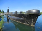
Visit Submarino O'Brien, Valdivia, Los Ríos, Chile
In 2002 the Chilean Navy sold the Oberon class submarine O' Brien (1972) to the city of Valdivia, Chile, where it currently serves as a museum. -
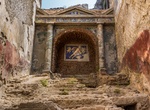
Visit Suburban Baths, Pompeii, Italy
The Suburban Baths (ItalianTerme Suburbane) are a building in Pompeii, Italy, a town in the Italian region of Campania that was buried by the eruption of Mount Vesuvius in 79 AD, which consequently preserved it. The Suburban Baths were publicly owned, as were also the Stabian, Forum, and Central baths in the city. They were built in the early empire, possibly under th... -
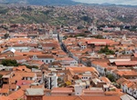
Visit Sucre, Bolivia (UNESCO site)
Sucre is the constitutional capital of Bolivia and the capital of the department of Chuquisaca. On November 30, 1538, Sucre was founded under the name Ciudad de la Plata de la Nueva Toledo by Pedro Anzures, Marqués de Campo Redondo. In 1538, the Spanish King Philip II established the Audiencia de Charcas in La Plata with authority over an area which covers wh... -
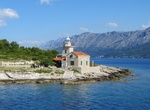
See Sućuraj Lighthouse, Sućuraj, Hvar Island, Croatia
Sućuraj Lighthouse is at the eastern point of Hvar Island. -
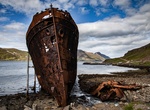
See Suðurland Shipwreck, Djúpavík, Westfjords, Iceland
M. Davidsen was the name of a passenger ship in Iceland which began operations in 1891. It was 217 Gross register tonnage and 35.25 m (115.6 ft) long by 6.21 m (20.4 ft) wide by 4.86 m (16.0 ft) deep. It had room for 14 passengers. The ship was purchased from Denmark for 225,000 Icelandic króna in 1919 and used to move people and goods between Reykjavík ... -
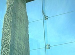
Visit Sueno's Stone, Forres, Scotland
Sueno's Stone is a Picto-Scottish Class III standing stone on the north-easterly edge of Forres in Moray and is the largest surviving Pictish style cross-slab stone of its type in Scotland, standing 6.5 metres (21 feet) in height. It is situated on a raised bank on a now isolated section of the former road to Findhorn. The stone is named after Sweyn Forkbeard, but thi... -
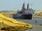
See Suez Canal, Egypt
The Suez Canal, also known by the nickname "The Highway to India", is an artificial sea-level waterway in Egypt, connecting the Mediterranean Sea and the Red Sea. Opened in November 1869 after 10 years of construction work, it allows transportation by water between Europe and Asia without navigation around Africa. The northern terminus is Port Said and the southern te... -
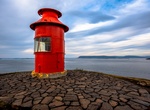
See Súgandisey Island Lighthouse, Stykkishólmur, Iceland
Súgandisey Island Lighthouse is located in Stykkishólmur, Iceland. Great place to take a photo of the town and the lighthouse. -
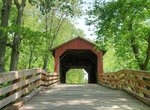
See Sugar Creek Covered Bridge, Illinois
Sugar Creek Covered Bridge is a covered bridge which crosses Sugar Creek southeast of Chatham, Illinois. The Burr truss bridge is 110 feet (34 m) long and 30 feet (9.1 m) wide. The bridge was constructed by Thomas Black; sources disagree on the date of construction, placing it at either 1827 or 1880. The State of Illinois acquired the bridge in 1963 and extensively re... -
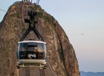
Ride Sugarloaf Cable Car, Rio de Janeiro, Brazil
The Sugarloaf Cable Car (Bondinho do Pão de Açúcar) is a cableway in Rio de Janeiro, Brazil. Moving between Praia Vermelha and the Sugarloaf Mountain, it stops at Morro da Urca (at 722 feet (220 m)) on its way up and down, and reaches the summit of the 1,299-foot (396 m) mountain. The cableway was envisioned by the engineer Augusto Ferreira Ramos ... -
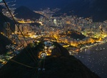
See View from Sugarloaf Mountain, Rio de Janeiro, Brazil (UNESCO site)
Sugarloaf Mountain, is a peak situated in Rio de Janeiro, Brazil, at the mouth of Guanabara Bay on a peninsula that sticks out into the Atlantic Ocean. Rising 396 metres (1,299 ft) above the harbor, its name is said to refer to its resemblance to the traditional shape of concentrated refined loaf sugar. The mountain is only one of several monolithic morros of granite ... -
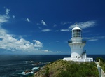
See or Stay at Sugarloaf Point Light, New South Wales, Australia
Sugarloaf Point Light, also known as Seal Rocks Lighthouse, is an active lighthouse located on Sugarloaf Point, a point about 3 kilometres (1.9 mi) southeast of Seal Rocks, New South Wales, Australia. It guards Seal Rocks, a treacherous rock formation to the south. It is the first lighthouse designed by James Barnet. It is also one of only two towers in Australia with... -
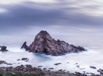
See Sugarloaf Rock, Western Australia
Sugarloaf Rock, also known as Sugarloaf Rocks and Sugar Loaf Rock, is a large, natural granite island in the Indian Ocean just off the coast situated approximately 2 kilometres (1.2 mi) south of Cape Naturaliste in the South West region of Western Australia. It is separated from the mainland by a thin channel of treacherous water. The rock is one of the most photograp... -
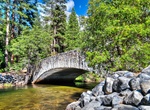
Walk across Sugar Pine Bridge, Yosemite Valley
The Sugar Pine Bridge (1928), also historically known as the Kenneyville Bridge No. 2, spans 106 feet (32 m) at a five-degree skew across the river, with a 27-foot (8.2 m) roadway, a 5-foot (1.5 m) sidewalk and a 7-foot (2.1 m) sidewalk. It carries the Mirror Lake Road. The bridge was named for a large sugar pinethat grew to the north of the east bridge abutment.
Price: $398.24