Give us feedback!

Our philosophy is simple. We want to encourage you to dream. BIG! Then we help you plan your trip, get the most out of it while you're traveling and help you share your experience with friends.
Join Now It's FREE
Related Categories
- Arizona State Parks
- Australian National Parks & Reserves
- Canada Provincial Parks
- Canadian National Parks
- New Zealand National Parks
- Parks & Reserves
- South African National Parks
- UK National Parks
- UNESCO Parks & Preserves
- US Historical Parks (NHP)
- US National Parks
- US Parks & Landmarks
- US State Parks
Dreams Still To Do
Checked-Off Dreams
Dreams Still To Do
Checked-Off Dreams
Advertisement
Explore Parks
-
Explore Mount Tabor, Portland, Oregon
Mount Tabor is an extinct or dormant volcanic vent, the city park on the volcano, and the neighborhood of Southeast Portland, Oregon that surrounds it. The name refers to Mount Tabor, Israel. It was named by Plympton Kelly, son of Oregon City pioneer resident Clinton Kelly. The peak of Mount Tabor is 636 feet (194 m) in elevation; about two-thirds of this is prominenc... -
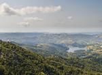
Explore Mount Tamalpais State Park, California
Mount Tamalpais State Park is a California state park, located in Marin County, California. The primary feature of the park is the 2,571 feet (784 m) Mount Tamalpais. The park contains mostly redwood and oak forests. The mountain itself covers around 25,000 acres (100 km2). There are about 60 miles (97 km) of hiking trails, which are connected to a larger, 200 miles (... -
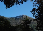
Explore Mount Tâmpa, Brașov, Romania
Tâmpa is a mountain, part of the Postăvarul Massif, located in the southern part of the Eastern Carpathians (alternatively categorized as in the Curvature Carpathians) and almost entirely surrounded by the city of Braşov. Its elevation is 960 m (995 m according to some sources), almost 400 m above the city. The mountain is mostly made up of limestone formations,... -
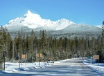
Visit Mount Thielsen Viewpoint, Oregon
Frame this ancient 9,182-foot volcano in your camera lens and you will see why it’s called the "Lightning Rod of the Cascades.” -
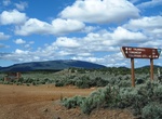
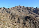
Explore Mount Tipton Wilderness, Arizona
The Mount Tipton Wilderness is a 30,760-acre wilderness area located in northwestern Arizona that comprises the north portion of the Cerbat Mountains. Mount Tipton, at 7,148 feet, is the wilderness area’s highest peak, and the community of Dolan Springs the nearest access point. Dolan Springs is located on the northwest flank of the Cerbat Mountains and directly... -
Explore Mount Tomorr National Park, Albania
Mount Tomorr is a large mountain located in modern-day southern Albania. Its highest peak, called Çuka e Partizanit, reaches a height of 2,416 m (7,927 ft). TheTomorr Mountain National Park (Parku Kombëtar i Malit të Tomorrit) covers an area of 24,723 hectares. Mount Tomorr offers many sports facilities such as skiing. For its importance and beauty, t... -
Off-road Mount Trumbull Scenic Loop Drive, Arizona
Start this loop at the Mt Trumbull Schoolhouse at Mohave County Road 5 (CR5 - Southern Section). To get there from Interstate 15, take Exit 2 east onto the Southern Parkway (Hwy 7) toward the airport. Take Exit 3 (River Road) and turn south. Set your vehicle trip odometer to 0 where the pavement ends at the state line. BLM Road 1069: You have now crossed into Ariz... -
Hike Mount Victoria, Mindat, Myanmar
Nat Ma Taung, also known as Mount Victoria and Khaw-nu-soum or Khonuamthung in Chin, is the highest mountain in the Chin State of western Burma. Located in 3 Townships - Kanpatlet, Mindat and Matupi, Mount Victoria is part of the Chin Hills range. The park is administered by the Department of Forestry and Environment. With a height of 3,053 metres (10,016 ft) above se... -
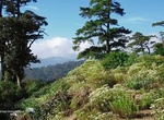
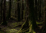
Explore Mount Victoria Forest Reserve, Tasmania, Australia
Mount Victoria Reserve is a temperate rainforest area in the North East portion of the Australian state of Tasmania. It is of acknowledged conservation significance and was identified as a high priority Recommended Area for Protection (RAP) by authorities during the 1980s and protected as part of the Comprehensive and Representative (CAR) Reserve system touted by Tasm... -
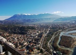
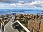
Visit Mount Wellington (Kunanyi) Summit, Tasmania, Australia
Mount Wellington, officiallykunanyi / Mount Wellington, incorporating its conlang name (real Aboriginal:unghbanyahlettaorpoorawetter), is a mountain in the southeast coastal region of Tasmania, Australia. It is the summit of the Wellington Range and is within the Wellington Park reserve. Located at the foothills of the mountain is much of Tasmania's capital city, Hoba... -
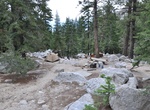
Camp at Mount Whitney Trailhead Campground (Whitney Portal), Lone Pine, California
Located in the "Ravine" on the east side of the overflow parking lot at Whitney Portal, all campsites are walk-in. Camping is not allowed in the parking lot. Sites have flat tent pads and bear proof food lockers. Restrooms are located at the parking lot. No water. One night stay limit. No reservations. Self-register at campground sign in hiker parking lot. -
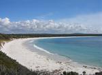
Explore Mount William National Park (Bay of Fires), Tasmania, Australia
Bay of Fires in Tasmania beaches are perfect. Lonely Planet listed it as its "world's hottest travel destination for 2009". The Bay of Fires is a bay on the northeastern coast of Tasmania in Australia, extending from Binalong Bay to Eddystone Point. The bay was given its name in 1773 by Captain Tobias Furneaux in Adventure, who saw the fires of Aboriginal people on th... -
Explore Mount Wilson Wilderness, Arizona
Rugged and sublime landscapes with nothing but the wind and bird songs to break the silence are the main attraction at Mount Wilson Wilderness. Though this wilderness area may look stark and forbidding, it can be deceiving, hiding several dependable year-round springs that support wildlife. Keep your eyes peeled for desert bighorn sheep as well as evidence of old mini... -
Visit Mount Wutai Temples, China (UNESCO site)
Mount Wutai ("Five Plateau Mountain"), also known as Wutai Mountain or Qingliang Shan, located in Shanxi, China, is one of the Four Sacred Mountains in Chinese Buddhism. The mountain is home to many of China's most important monasteries and temples. Mount Wutai's cultural heritage consist of 53 sacred monasteries, and they were inscribed as a UNESCO World Heritage Sit... -
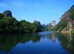
Explore Mount Wuyi, China (UNESCO site)
The Wuyi Mountains are a mountain range located in the prefecture of Nanping, in the northern border of Fujian province with Jiangxi province, China. The mountains cover an area of 60 km². In 1999, Mount Wuyi entered UNESCO's list of World Heritage Sites, both natural and cultural. It is the most outstanding biodiversity conservation zone of Southeast China. Nume...