Give us feedback!

Our philosophy is simple. We want to encourage you to dream. BIG! Then we help you plan your trip, get the most out of it while you're traveling and help you share your experience with friends.
Join Now It's FREE
Related Categories
- Arizona State Parks
- Australian National Parks & Reserves
- Canada Provincial Parks
- Canadian National Parks
- New Zealand National Parks
- Parks & Reserves
- South African National Parks
- UK National Parks
- UNESCO Parks & Preserves
- US Historical Parks (NHP)
- US National Parks
- US Parks & Landmarks
- US State Parks
Dreams Still To Do
Checked-Off Dreams
Dreams Still To Do
Checked-Off Dreams
Advertisement
Explore Parks
-
Visit Mugdock Castle & Park, Milngavie, Glasgow, Scotland
Mugdock Country Park is a country park and historical site located partly in East Dunbartonshire and partly in Stirling, in the former county of Stirlingshire, Scotland. It is around 10 miles (16 kilometres) north of Glasgow, next to Milngavie (from which the park is easily accessible), and covers an area of 260 hectares (642 acres). The park includes the remains of t... -
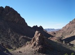
Explore Muggins Mountain Wilderness, Arizona
The Muggins Mountain Wilderness is a 7,711-acre (31.21 km2) wilderness area in the U.S. state of Arizona. It is located approximately 38 miles (61 km) east of Yuma, Arizona in the Muggins Mountains and adjacent to the agriculturalDome Valleyand Gila River. The wilderness area is made up of the highest peak in the southern section of Muggins Mountains, Klothos Temple a... -
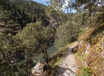
Hike to Muir Trail Ranch, John Muir Wilderness, California
Muir Trail Ranch is a mid-way stop for backpackers thru-hiking the 211-mile John Muir Trail. Sleep in a campaign tent or a log cabins, eat communal dinners like steaks barbecued on a wood-fired grill, and then soak in 107-degree hot spring baths. -
Explore Muir Woods National Monument, California
Muir Woods National Monument is a unit of the National Park Service on the Pacific coast of southwestern Marin County, California, 12 miles (19 km) north of San Francisco and part of the Golden Gate National Recreation Area. It protects 554 acres , of which 240 acres are old growth Coast Redwood (Sequoia sempervirens) forests, one of a few such stands remaining in the... -
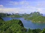
Explore Mu Ko Ang Thong National Park, Thailand
Mu Ko Ang Thong is a marine national park in the Gulf of Thailand located 31 km. west of Samui, Thailand. The parks consists of 42 separate islands, the principle islands being; Phaluai, Wua Ta Lap, Mae Ko, Sam Sao, Hin Dap, Nai Phut and Phai luak. Most of the islands consists of limestone mountains about 10-400 meters above sea level. The eroded limestone gives the i... -
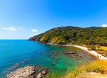
Explore Mu Ko Lanta National Park, Thailand
Mu Ko Lanta National Park is a national park in the southern part of Krabi Province, Thailand, consisting of several islands. The two largest islands are Ko Lanta Noi and Ko Lanta Yai. Although both are inhabited, Ko Lanta Yai is the primary tourist destination. The park was established in 1990 and altogether covers 134 km². Ko Lanta is mountainous and rugged, es... -
Hike Mule Creek Trail, Oregon
The Mule Creek Trail #1159, located on the Bureau of Land Management portion of the wilderness, provides a steep route on an out mining trail between the river and Panther Ridge. In general cross-country travel is not advised due to steep slopes and heavy vegetation. The Forest Service administers the entire wilderness, including the Bureau of Land Management portion,... -
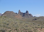
Visit Mule Ears Viewpoint, Big Bend National Park, Texas
Vista point in Big Bend National Park along the Ross Maxwell Scenic Drive. From the parking area, the Mule Ears Peaks dominate the view. -
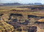
Drive to Muley Point, Utah
Muley Point is a remote, scenic overlook in southern Utah near Mexican Hat. The view provides panoramic vistas of the desert landscape of southern Utah and northern Arizona. Monument Valley is visible in the distance while the San Juan River cuts into the canyon below. It's really worth the effort to get here! This is a peaceful isolated place that has few visitors, ... -
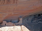
Visit Mummy Cave Overlook, Canyon de Chelly National Monument, Arizona
Mummy Cave Overlook is along the North Rim Drive Hwy in Canyon de Chelly National Monument. -
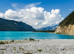
Explore Muncho Lake Provincial Park, British Columbia, Canada
Muncho Lake Provincial Park is a provincial park in British Columbia, Canada, located on the Alaska Highway as it transits the northernmost Canadian Rockies west of Fort Nelson. The park is part of the larger Muskwa-Kechika Management Area. It is named after Muncho Lake, which is in the park and is both the name of the lake and of the community located there. -
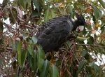
Birding at Mundaring-Kalamunda, Western Australia
The Mundaring-Kalamunda Important Bird Area comprises a fragmented 137 km2 of land centred on the towns of Mundaring and Kalamunda in the Darling Scarp region of Western Australia. The boundaries of the Important Bird Area (IBA) are defined by the presence of blocks of native vegetation greater than 1 ha within a 6 km foraging radius of two prominent, non-breeding sea... -
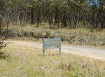
Explore Mundoonen Nature Reserve, NSW, Australia
Mundoonen Nature Reserve was created in February 1970. It covers an area of 1471ha. It's located in New South Wales along route M31. A small population of koalas has been identified in Mundoonen Nature Reserve however little is known about their current density and distribution. -
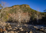
Explore Munds Mountain Wilderness, Coconino National Forest, Arizona
Munds Mountain Wilderness is an 18,150-acre (7,345 ha) wilderness area in the Coconino National Forest in the U.S. state of Arizona. It is immediately southeast of Sedona between Arizona State Route 179 and Interstate 17. The wilderness lies within the Munds Mountain and Sedona quadrangles of the national topographic map of the United States Geological Survey. Several... -
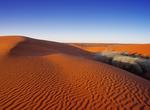
Explore Munga-Thirri National Park (Simpson Desert), South Australia, Australia
Munga-Thirri—Simpson Desert Conservation Park (formerly Simpson Desert Conservation Park and Simpson Desert National Park) is a protected area located in the Australian state of South Australia about 970 kilometres (600 mi) north of the state capital of Adelaide and above 215 kilometres (134 mi) north-east of the town of Oodnadatta. The conservation park occupie...