Give us feedback!


 See all

Our philosophy is simple. We want to encourage you to dream. BIG! Then we help you plan your trip, get the most out of it while you're traveling and help you share your experience with friends.
Join Now It's FREE
Dream Packages
Duration: 9 hours
Price: $109.14
Price: $109.14
Duration: 7 hours
Price: $179.00
Price: $179.00
Duration: 6 days
Price: $606.00
Price: $606.00
Duration: 7 hours
Price: $144.00
Price: $144.00
Dreams Still To Do
Checked-Off Dreams
Dreams Still To Do
Checked-Off Dreams
Advertisement
Explore Adventure Sports
-
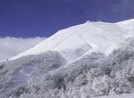
Ski or Snowboard Cerro Chapelco, Argentina
Chapelco, or Cerro Chapelco, is a mountain and massif in southwestern Argentina. The ski station of the same name is located 19 kilometres (12 mi) from the resort town of San Martín de los Andes. Cerro Chapelco is a modern ski resort with some good lifts and tree skiing. Cerro Chapelco has only 140 hectares of skiable terrain, 22 trails and 73 meters of vertic... -
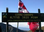
Summit Cerro Chirripó, Costa Rica
Cerro Chirripó is the highest mountain in Costa Rica, with an altitude of 3,820 metres (12,533 ft). It is located in the Chirripó National Park and is noted for its ecological wealth. The high peaks in this and La Amistad International Park host important areas of Talamancan montane forest and Costa Rican Páramo with high endemism and an extremely... -
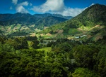
Summit Cerro de Punta, Ponce, Puerto Rico
Cerro de Punta or just Cerro Punta is the highest peak in Puerto Rico, rising to 1,338 meters (4,390 ft) above sea level. The mountain is part of the Cordillera Central and is located in the municipality of Ponce. The mountain is part of the Cordillera Central and is located on the border between the municipalities of Jayuya and Ponce. The access road to the point clo... -
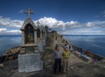
Hike to Cerro El Calvario, Copacabana, Bolivia
The hilltop overlooking Lake Titicaca was rededicated as a "calvario" or replica of Calvary and is topped by the Stations of the Seven Sorrows of Mary and an altar with a depiction of the crucifixion of Jesus. It is a major centre of worship throughout the region during Holy Week, especially on Good Friday and Easter Sunday. -
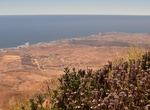
Summit Cerro El Coronel, Rosarito, Baja California, Mexico
One of the most popular hikes in the Rosarito area is Cerro El Coronel. The hike up the large hill is moderate and takes 5-7 hours so be sure to take plenty of drinking water and snacks. There are signs for the trail that you’ll find along the free road near Puerto Nuevo. For an easier hike, there are a number of trails surrounding the new Parque Metropolitano, ... -
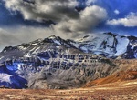
Summit Cerro El Plomo, Santiago
Cerro El Plomois a mountain located in the Andes near Santiago, Chile. With an elevation of 5,434 m (17,783 ft), it is the largest peak visible from Santiago on clear days. The adequate season to climb this mountain is between November and March. In spring (September to November), soil conditions have abundant snow on the approach. The best time is in January and Marc... -
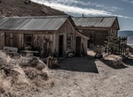
Off-road to Cerro Gordo Mines, California
The Cerro Gordo Mines are a collection of abandoned mines located in the Inyo Mountains, in Inyo County, California. Mining operations were undertaken from 1866 until 1957, producing high grade silver, lead, and zinc ore. Some ore was smelted on site, but larger capacity smelters were eventually constructed along the shore of nearby Owens Lake. These smelting operatio... -
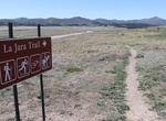
Hike Cerro la Jara Trail, Valles Caldera National Preserve, New Mexico
You are walking in a volcanic caldera – a depression formed during a volcanic eruption. This caldera was formed as the result of a very large volcanic eruption about 1.2 million years ago. It is somewhat circular in shape and 12 to 15 miles across. Alluvial fans get their name from their shape and what they are made of. Rocks, sand, and silt moved and deposited ... -
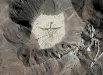
See Cerro Prieto Rock Graphiti, Mexicali, Baja California, Mexico
Cerro Prieto ("Black Hill") is a volcano located approximately 29 km (18 mi) SSE of Mexicali in the Mexican state of Baja California. The volcano lies astride a spreading center associated with the East Pacific Rise. This spreading center is also responsible for a large geothermal field which has been harnessed to generate electric power by the Cerro Prieto Geothermal... -
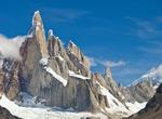
Climb Cerro Torre, Argentina & Chile
Cerro Torre is one of the mountains of the Southern Patagonian Ice Field in South America. It is located in a region which is disputed between Argentina and Chile, west of Cerro Chalten (also known as Fitz Roy). The peak is the highest in a four mountain chain: the other peaks are Torre Egger (2,685 m), Punta Herron, and Cerro Stanhardt. The top of the mountain often ... -
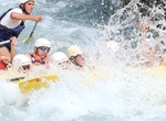
Whitewater Raft Cetina River, Croatia
Cetina (pronounced [tsětina]) is a river in southern Croatia. It has a length of 101 km (63 mi) and its basin covers an area of 1,463 km2 (565 sq mi). From its source, Cetina descends from an elevation of 385 metres (1,263 ft) above sea level to the Adriatic Sea. It is the most water-rich river in Dalmatia. Cetina is very popular amo... -
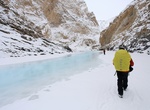
Hike Chadar Trek, Zanskar Gorge, Kashmir, India
The Chadar Trek through the Zanskar Gorge is a winter expedition in the Himalaya. The river ice can shift and break and present other hazards, but the biggest danger is the cold itself. The Zanskar Gorge is found in the Zanskar region of Indian-administered Kashmir. Its walls are near vertical cliffs up to 600m high and the Zanskar River (a tributary of the Indus) is ... -
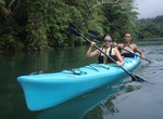
Kayak Chagres River, Panama
The Chagres River (Spanish pronunciation: [ˈtʃaɣɾes]), in central Panama, is the largest river in the Panama Canal's watershed. The river is dammed twice, and the resulting reservoirs—Gatun Lake and Lake Alajuela—form an integral part of the canal and its water system. Although the river's natural course runs northwest into the Caribbean Sea, its waters al... -
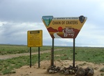
Drive Chain of Craters Backcountry Byway, New Mexico
The Chain of Craters Backcountry Byway is a 33-mile backcountry byway located in El Malpais National Conservation Area (NCA) and National Monument in northwestern New Mexico. The byway, which is County Road 42, passes almost exclusively through public lands. County Road 42 forms the western boundary of the West Malpais Wilderness and connects NM 53 and NM 117. The C...

Price: $83.37