Give us feedback!


 See all

Our philosophy is simple. We want to encourage you to dream. BIG! Then we help you plan your trip, get the most out of it while you're traveling and help you share your experience with friends.
Join Now It's FREE
Dream Packages
Duration: 8 hours
Price: $208.72
Price: $208.72
Duration: 4 hours 30 minutes
Price: $176.03
Price: $176.03
Duration: 9 hours
Price: $109.14
Price: $109.14
Duration: 3 hours
Price: $173.83
Price: $173.83
Dreams Still To Do
Checked-Off Dreams
Dreams Still To Do
Checked-Off Dreams
Advertisement
Explore Adventure Sports
-
Ride through the Channel Tunnel (Chunnel), England & France
The Channel Tunnel, (also referred to as the Chunnel) is a 50.5-kilometre (31.4 mi) undersea rail tunnel linking Folkestone, Kent in England with Coquelles, Pas-de-Calais near Calais in northern France beneath the English Channel at the Strait of Dover. At its lowest point, it is 75 metres (250 ft) deep. At 37.9 kilometres (23.5 mi), the Channel Tunnel possesses the l... -
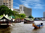
Ride a boat at Chao Phraya River, Bangkok, Thailand
Chao Phraya River is the major river in Thailand, with its low alluvial plain forming the centre of the country. It flows through Bangkok and then into the Gulf of Thailand. The Chao Phraya begins at the confluence of the Ping and Nan rivers at Nakhon Sawan (also called Pak Nam Pho) in Nakhon Sawan Province. After this it flows south for 372 kilometres (231 mi) from ... -
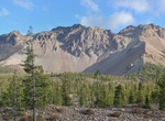
Hike Chaos Crags, Lassen Volcanic National Park, California
Chaos Crags is the youngest group of lava domes in Lassen Volcanic National Park, California, having been formed as five dacite domes 1,100-1,000 years ago. The cluster of domes is located north of Lassen Peak. From the base of the crags and extending toward the northwest corner of the park is Chaos Jumbles, a cold rock avalanche which undermined Chaos Crags' northwes... -
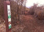
Hike Chaparral Crest Trail to El Nido Trailhead, Ojai, California
This Chaparral Crest Trail to El Nido Trailhead is about 2.4 miles long (each way) and located near Ojai, California. The trail is great for hiking and normally takes 2 hours (round trip) more or less. This guide takes you from the end of a 2.4 outing, back to one of 3 available trail heads. This is part of a reall great Ojai Land Conservancy trail system along the Ve... -
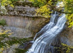
Hike to Chapel Falls, Pictured Rocks National Lakeshore, Michigan
Chapel Falls is located about 15 miles east of Munising off Alger County Road H-58, then about 5 miles north to the end of Chapel Road. After a brisk 1.5 mile walk, hikers can view the 60-foot high Chapel Falls as it cascades toward Chapel Lake.The trail is on an old roadbed with several small hills. Two viewing platforms along the way provide views of the scenic Chap... -
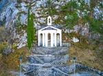
Hike to Chapel Santa Barbara, Riva del Garda, Lake Garda, Italy
Hiking trail to the St. Barbara Chapel. This picturesque chapel was built by the miners during the construction of the Hydroelectrical power plant. Wonderful view of the lake and Riva del Garda downtown. -
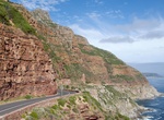
Drive or Cycle Chapman's Peak Drive, South Africa
Chapman's Peak is the name of a mountain on the western side of the Cape Peninsula, about 15 kilometres south of Cape Town, South Africa. It is opposite the inlet on which the town of Hout Bay is centred. The western flank of the mountain falls sharply for hundreds of metres into the Atlantic Ocean. A spectacular road, known as Chapman's Peak Drive, hugs the near-vert... -
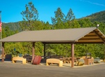
Off-road Chappie-Shasta OHV Area, Shasta Lake, California
Visitors to the rolling, brushy hills near Shasta Lake in northern California will find off-highway vehicle (OHV) riding challenges for all abilities. More than 250 miles of roads and trails are open to motorcyclists, all-terrain vehicle drivers and four-wheelers. The area is near massive Shasta Dam and Shasta Lake, and there are overlooks of the Sacramento River belo... -
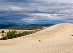
Explore Chara Sands "Desert in Siberia", Russia
Chara Sands is a 37 square kilometers (14 sq mi) area of sand dunes 40 kilometers from the Kodar Glaciers in Kalar district of Trans-Baikal region of Russia. Chara Sands is like a real desert, but with features you won’t see anywhere else. Some of the dunes are as high as 15 – 30 meters. The town of Novaya Chara is the starting point for trekking tours in... -
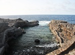
Swim at Charco Manso, El Hierro Island, Canary Islands
Charco Manso is a beautiful little swimming hole. Not many visitors. -
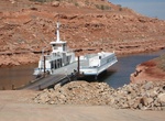
Ride Charles Hall Ferry, Glen Canyon National Recreation Area, Utah
The Charles Hall Ferry, which provides vehicle and pedestrian traffic services across Lake Powell between Bullfrog and Halls Crossing, is back in seasonal operation. From Halls Crossing to Bullfrog via State Route 95 is a distance of 125 miles. Bullfrog to State Route 95 is a distance of 34 miles. Halls Crossing to State Route 95 is a distance of 34 miles. -
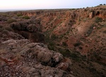
Drive Charles Knife Gorge Rd, Cape Range National Park, Western Australia
The Charles Knife Canyon drive takes you on a winding road from the main road south of Exmouth up to the top of the range. Located at the top is Charles Knife lookout. The Charles Knife Canyon includes a picnic area and the historical Wapet Oil Well No. 3 site. Visitors can also walk the Badjirrajirra Loop Trail via the picnic area. For more information on this wal... -
Visit Charles River, Boston, Massachusetts
The Charles River (sometimes called the River Charles or simply the Charles) is an 80-mile (129 km) long river in eastern Massachusetts. From its source in Hopkinton the river's mouth is northeast of its headwaters, though it follows a highly meandering route, doubling back on itself several times and traveling through 23 cities and towns before reaching the Atlantic ... -
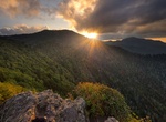
Backpack to Charlies Bunion, Great Smoky Mountains
Charlies Bunion is a mountain in the Great Smoky Mountains of the Southeastern United States, characterized by a large boulder-like protrusion just below the summit on its otherwise-sheer northern face. The mountain is a rare instance of a bare-rock summit in the Smokies. Charlies Bunion rises to an elevation of 5,565 feet (1,696 m) above sea level, and is situat... -
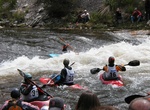
Kayak or Surf Charlie's Hole (Yampa River), Steamboat Springs, Colorado
The Yampa River in Steamboat Springs has the A, B, and D holes, but the C-Hole, or Charlie’s Hole is the best. It’s surfable on SUPs and shortboards if flows are good.


Price: $83.37