Give us feedback!


 See all

Our philosophy is simple. We want to encourage you to dream. BIG! Then we help you plan your trip, get the most out of it while you're traveling and help you share your experience with friends.
Join Now It's FREE
Dream Packages
Duration: 7 hours
Price: $179.00
Price: $179.00
Duration: 6 days
Price: $606.00
Price: $606.00
Duration: 9 hours
Price: $109.14
Price: $109.14
Duration: 15 hours
Price: $149.00
Price: $149.00
Dreams Still To Do
Checked-Off Dreams
Dreams Still To Do
Checked-Off Dreams
Advertisement
Explore Adventure Sports
-
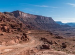
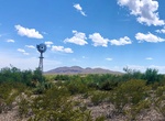
Off-road or Mountain Bike Chicken Corners Safari Trail & Kane Springs Road, Moab, Utah
Chicken Corners Safari Trail is a very popular ATV, UTV and dirt bike area near Moab, Utah. Descend the dramatic west side of Hurrah Pass to the Colorado River. Explore natural caves at Catacomb Rock. From Chicken Corners, look across river to see dramatic Thelma & Louise Point. Camp in designated sites only in Kane Creek Canyon. -
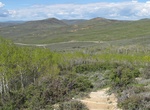
Hike Chicken Creek Nature Trail Loop, Fossil Butte National Monument, Wyoming
This trail is easy to moderate. There is some shade on this trail while the aspen trees have leaves on them. Pack sunscreen bug spray, a hat, and plenty of water.This trail winds through sagebrush and a spring-fed aspen forest. Wildflowers are plentiful in spring and many animals including birds, marmots, elk, pronghorn, and occasionally moose can be seen along the tr... -
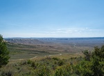
Drive Chicken Creek Road Scenic Drive, Fossil Butte National Monument, Wyoming
A 5.5 mile scenic drive (2.5 miles paved, 3 miles improved gravel) provides scenic views of Fossile Butte, the Wasatch Formation badlands and wildlife. CAUTION: The gravel road begins with a 17% grade. Moter homes and vehicles towing trailers are encouraged to turn around at the picnic area. There are a few side dirt roads along the route: Cundick Ridge Road - 4... -
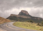
Drive Chief Joseph Scenic Highway (HWY 296), Wyoming
Wyoming Highway 296 also known as the Chief Joseph Scenic Highway is in the U.S. state of Wyoming and follows the route taken by Chief Joseph as he led the Nez Perce Indians out of Yellowstone National Park and into Montana in 1877 during their attempt to flee the U.S. Cavalry and escape into Canada. Access to Yellowstone National Park's northwest entrance is off the ... -
Hike or Ride Chief Ladiga Trail, Alabama
The Chief Ladiga Trail is a rail trail in Alabama. It is the state's first rail trail project. The 33-mile (53 km) trail stretches from the Alabama-Georgia state line to Weaver. The Chief Ladiga is on the same rail corridor as the Silver Comet Trail in Georgia as far as Piedmont, Alabama. From there it parallels an abandoned Southern Railway line for a few miles west ... -
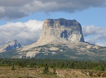
Summit Chief Mountain, Glacier National Park, Montana
Chief Mountain (also called Old Chief Mountain) is located in the U.S. state of Montana on the eastern border of Glacier National Park and the Blackfeet Indian Reservation. The mountain is one of the most prominent peaks and rock formations along the Rocky Mountain Front, a 200 mi (320 km) long overthrust fault, known as the Lewis Overthrust, which extends from centra... -
Drive or Ride Chief Mountain Highway, US & Canada
The Chief Mountain Highway offers exhilarating vistas of the Waterton and Blakiston valleys. The Chief Mountain Highway is the primary route between Waterton Lakes National Park and Glacier National Park (U.S). The highway climbs from the grasslands near Maskinonge Lake to a viewpoint which offers a magnificent panorama of the Waterton and Blakiston valleys (Chief Mou... -
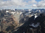
Trek Chigmit Mountains, Alaska
The Chigmit Mountains are a subrange of the Aleutian Range in the Kenai Peninsula and Lake and Peninsula Boroughs of the U.S. state of Alaska. They are located at the northeastern end of the Aleutian range, on the west side of Cook Inlet, roughly 120 miles (200 km) southwest of Anchorage. The closest major towns to the range are Kenai and Homer, across Cook Inlet on t... -
Hike Chihuahuan Desert Nature Trail, Big Bend National Park, Texas
Both natural and cultural history are evident at Dugout Wells. On this easy desert stroll you will see remnants of human settlement and typical Chihuahuan Desert habitat. A shady oasis with cottonwood trees and tables at Dugout Wells provides a good area for picnicking and bird watching. Begin at Dugout Wells, 6 miles southeast of Panther Junction. -
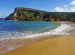
Visit Childers Cove Beach, Victoria, Australia
Childers Cove Beach is located in Mepunga, Victoria, Australia -
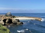
See Seals at Children's Pool (Casa Beach), La Jolla, California
Children's Pool Beach, also known as Casa Beach, is a small sandy beach located at 850 Coast Boulevard, at the end of Jenner Street, in La Jolla, California. Children’s Pool is closed from December 15 to May 15 to protect the newly-born seal pups. A sea wall built in 1931 protects the beach from waves, making it a favorite spot for divers and swimmers. Before th... -
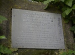
Hike to Chilean Memorial, Olympic National Park, Washington
The Chilean Memorial is a small plaque that remains to honor a shipwreck that left 18 people dead. It's located along the North Coast Route trail north of The Hole-In-The-Wall. -
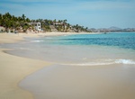
Visit Chileno Beach, Baja California Sur, Mexico
The clear turquoise waters makes the beach great for snokeling and swimming. Nice wide Beach with good parking, clean restrooms, and close rock formations to snorkel around. -
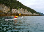
Kayak Chilkat River, Alaska
The Chilkat River is a river in British Columbia and southeastern Alaska that flows southward from the Coast Range to the Chilkat Inlet and ultimately Lynn Canal. It is about 80 kilometres (50 mi) long. It begins at Chilkat Glacier, in Alaska, flows west and south in British Columbia for 27 kilometres (17 mi), enters Alaska and continues southwest for another 60 kilom... -
Hike Chilkoot Trail, USA & Canada
The Chilkoot Trail is a 33-miles (53 km) trail through the Coast Mountains that leads from Dyea, Alaska, in the United States, to Bennett, British Columbia, in Canada. The trail can take 3 to 5 days. Each year, over 15,000 people day hike, backpack, or trail run this corridor. It was a major access route from the coast to Yukon goldfields in the late 1890s. The trail...

Price: $220.83