Give us feedback!


 See all

Our philosophy is simple. We want to encourage you to dream. BIG! Then we help you plan your trip, get the most out of it while you're traveling and help you share your experience with friends.
Join Now It's FREE
Dream Packages
Duration: 3 hours
Price: $173.83
Price: $173.83
Duration: 3 hours
Price: $140.24
Price: $140.24
Duration: 7 hours
Price: $144.00
Price: $144.00
Duration: 8 hours
Price: $208.72
Price: $208.72
Dreams Still To Do
Checked-Off Dreams
Dreams Still To Do
Checked-Off Dreams
Advertisement
Explore Adventure Sports
-
Dive in Chumphon Pinnacle, Ko Tao, Thailand
Chumphon Pinnacle is the best diving spot in Ko Tao and just the second in Gulf of Thailand, right after Sail Rock. It's only 40 min boat ride from the island and it's possible to see many fish species in crystal clear water. Four granite pinnacles carpeted with anemones. See Whale sharks (seasonal), giant grouper, barracuda, bull shark, batfish and tuna. Max Depth: 4... -
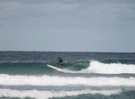
Surf Chun’s Reef, Haleiwa, Oahu, Hawaii
Chun’s Reef, often referred to simply as Chun’s, is located east of Haleiwa town on Kamehameha Highway right after Laniakea Beach. A popular spot for surf lessons, the beach has two main sections, a break closer to shore where beginners will find long, gentle waves, and a break further out where more advanced surfers. -
Visit Churaumi Aquarium, Okinawa, Japan
The Okinawa Churaumi Aquarium is located within the Ocean Expo Commemorative National Government Park in Okinawa, Japan. The aquarium is made up of four floors, with tanks containing deep sea creatures, sharks, coral and tropical fish. The aquarium is set on 19,000 m² of land, with a total of 77 tanks containing 10,000 m³ of water. Water for the saltwater ex... -
Hike up to Church of Panagia (Folegandros), Greece
The beautiful Church of Panagia on Folegandros is located on a fabulous spot above Chora offering an excellent view to the island and the sea. Its a tough walk up to the church during the hottest part of the day, but very pleasant in the late afternoon. The ancient akropolis of Folegandros is further up the hill, beyond the church. -
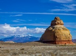
See Church Rock, Utah
Church Rock is a solitary column of sandstone in southern Utah along the eastern side of U.S. Route 191, near the entrance to the Needles District of Canyonlands National Park. With majestic Colorado and Green River canyons, Canyonlands, this 200 foot roadside oddity near Monticello is called Church Rock. It seldom attracts more than a casual glance as visitors h... -
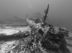
Wreck Dive Chuuk Lagoon (Truk Atoll), Fujikawa Maru, Micronesia
In 1969, French oceanographer Jacques Cousteau and his team explored Truk Lagoon. Following Cousteau's 1971 television documentary about the lagoon and its ghostly remains, the place became a scuba diving paradise, drawing wreck divingenthusiasts from around the world to see its numerous, virtually intact sunken ships. The shipwrecks and remains are sometimes referred... -
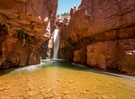
Hike to Cibecue Falls via Cibecue Creek Trail, Cibecue, Arizona
NOTE:A access permit to hike up to Cibecue Falls requires a fee per person/per day. Permits are available at the Carrizo C-Store (Sinclare gas station) which is open 6am-9pm. More information can be found at https://wmatoutdoor.org/wp_view.html?pageid=24 Cibecue Creek lies entirely within the Fort Apache Indian Reservation, within Navajo County, Arizona. The creek's w... -
Off-road Cigarette Springs Road (Cedar Mesa), Bears Ears National Monument, Utah
Cigarette Springs Road is a fairly well-maintained but rough road that cuts deep into the heart of Cedar Mesa area of Bears Ears National Monument. Cigarette Springs Road is about 19 miles from the U.S. 163 turnoff. Road Canyon and The Citadel are the main sites to hike. -
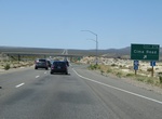
Drive Cima Road, Mojave Desert, California
Cima Road is a 15-mile long corridor from Kelso Cima Road to Ivanpah Road. It is a key link between Interstate 40 and 15, posted at 55mph with an approximate ADT of 650. The roadway width varies from 22 feet to 24 feet. The route is characterized by extremely soft shoulders, with numerous low water crossings. The proposed project includes: increasing the roadway width... -
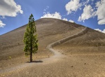
Summit Cinder Cone, Lassen Volcanic National Park, California
Cinder Cone is a 700 ft (213 m) high cone of loose scoria. Scoria forms when blobs of gas-charged lava are thrown into the air during an eruption and cool in flight, falling as dark volcanic rock containing cavities created by trapped gas bubbles. It's a 5 1/2 mile hike to the top of Cinder Cone where you can marvel at a landscape transformed by volcanic activity. -
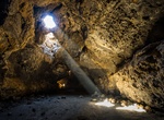
Explore Cinder Cone Lava Tubes, Mojave National Preserve, California
The lava tube is located about 5 miles east of Kelbaker Road on the unpaved and unsigned Aiken Mine Road. A High clearance vehicle is recommended. To Aiken Mine Road: From Interstate 15: 19 miles south of Baker, Calif. on Kelbaker Road; turn north (left) onto Aiken Mine Road. From Interstate 40: 28 miles west of Ludlow, Calif., turn north onto Kelbaker Road; continu... -
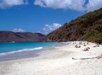
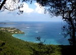
Visit Cinnamon Bay, St John, USVI
Cinnamon Bay is a body of water and a beach on St. John in the United States Virgin Islands, adjacent to the historic Cinnamon Bay Plantation. The bay is just east of Trunk Bay, and is about a mile west of a famous eco-tourism destination called Maho Bay Camps. The shallow, clear water and the short distance to Cinnamon Cay (a small, low-elevation, sandy island) make ... -
Hike Cinnamon Bay Trail, St John, USVI
Cinnamon Bay Self-Guided Trail offers boardwalk access which meanders through the historic ruins. This boardwalk trail entrance is located across from the exit gate of the Cinnamon Bay Campground. -
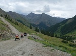
Off-road Cinnamon Pass Road, Colorado
This trail, combined with Engineer Pass, constitutes the famous Alpine Loop. Cinnamon Pass Road is a 9.2 mile out and back trail with a mslal section in a loop connection Animas Forks with American Basin. Cinnamon Pass sits 12,640’ above the San Juan Mountains. During the gold rush of Colorado, Cinnamon pass was used to reach what would soon be the town of Sil... -
Cruise Circle Line Sightseeing Cruise, New York City
The Circle Line is the collective name given to two sightseeing ferry operations in Manhattan: Circle Line Sightseeing Cruises at 42nd Street which circles Manhattan from its base at Pier 83 in Manhattan Circle Line Downtown operates out of Pier 16, South Street Seaport. The company name is Circle Line Harbor Cruises, LLC. It is a wholly owned subsidiary of Circle Li...


Price: $606.00