Give us feedback!


 See all

Our philosophy is simple. We want to encourage you to dream. BIG! Then we help you plan your trip, get the most out of it while you're traveling and help you share your experience with friends.
Join Now It's FREE
Dream Packages
Duration: 3 hours
Price: $140.24
Price: $140.24
Duration: 4 hours
Price: $120.43
Price: $120.43
Duration: 6 days
Price: $606.00
Price: $606.00
Duration: 2 days
Price: $242.00
Price: $242.00
Dreams Still To Do
Checked-Off Dreams
Dreams Still To Do
Checked-Off Dreams
Advertisement
Explore Adventure Sports
-
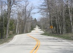
Drive Door County Curvy Highway (WI-42), Ellison Bay, Wisconsin
Near the northern terminus of Wisconsin Highway 42 is a section known as the Door County Curvy Highway. This unusually twisty stretch of Highway 42 was built in the early 1930s. Why was it built this way? It's probably a mix of a local landscape architect Jens Jensen who did not like stright lines - that locals have even nicknamed it “Jensen’s Road” ... -
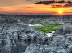
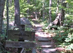
Hike Door Trail, Badlands National Park, South Dakota
An accessible ¼ mile boardwalk leads through a break in the Badlands Wall known as "the Door" and to a view of the Badlands. From there, the maintained trail ends. Travel beyond this point is at your own risk. Watch for drop-offs. The Door Trail is a great place to capture sunrise photos. -
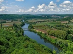
Cycle through Dordogne Valley, France
Bike through Dordogne Valley in France. Villages such as St-Céré, Autoire, Loubressac, Rocamadour and the lively town of Sarlat await cyclists touring the Dordogne Valley between Argentat and Beynac (110 miles/176 km). This region of France is known for its authenticity, great food, serene landscape, old Romanesque churches and castles and is steeped in ... -
Explore Dorob National Park, Namibia
Dorob National Park ("dry land") is a protected area in Erongo, along the central Namibian coast, which is 1,600 kilometres (990 mi) in length. It was gazetted as a national park under the Nature Conservation Ordinance No.4 of 1975 on 1 December 2010, and with Namib-Naukluft Park covers an area of 107,540 square kilometres (41,520 sq mi). The park extends from the Kui... -
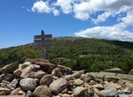
Summit Dorr Mountain, Acadia National Park, Maine
Hike to the summit of Dorr Mountain in Acadia National Park. There are several trails lading to the summit including: South Ridege Dorr Trail North Ridge Dorr Trail Ladder Trail/East Face Dorr Trail (Schiff Path) - pets not allowed on this trail. George Path -
Hike Dorr Mountain Loop, Acadia National Park, Maine
Hike to Dorr Mountain via Ladder Trail to Schiff Path and return via South Ridge Dorr Trail to Canon Brook Trail. Stone steps and iron rungs to open ridge and forest. Starts/ends at: ME 3, at the south end of The Tarn Round-trip distance: 3.3 miles (5.3 km) -
Off-road Dos Cabezas Road, Anza-Borrego Desert State Park, California
Dos Cabezas Road in Anza-Borrego Desert State Park starts at the Imperial Highway (S2), 4 miles northwest of Ocotillo. It follows the Bajada along the base of the Jacumba Mountains. It continues along the wide sandy trail between the Jacumba and Coyote Mountains. In spring the valley is covered with orange ocotillos in full bloom, making this a pleasant sight. Part o... -
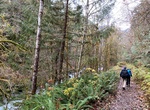
Hike Dosewallips River Trail, Olympic National Forest, Washington
Dosewallips River Road Trail is a 12.6 mile out and back trail located near Brinnon, Washington that features a waterfall and is rated as moderate. The trail is primarily used for hiking, running, camping, and nature trips. -
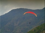
Paraglide Dos Hermanas (Two Sisters), El Hierro Island, Canary Islands
One of the most famous places for paragliding is the Dos Hermanas peak in the northwest of the island of El Hierro. -
Ride in Double-Decker Bus
A double-decker bus is a bus that has two storeys or decks. Red double-decker buses are used for mass transit in London. Double-decker buses are also used in other cities in Europe, Asia, and former British colonies and protectorates such as Hong Kong and Singapore. Almost all double-deckers have a single, rigid chassis. This type of bus is often used for touring rath... -
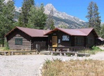
Camp at Double Diamond Dude Ranch Dining Hall, Grand Teton National Park
The Double Diamond Dude Ranch Dining Hall was built in 1945 as the centerpiece of a dude ranch operated by Frank Williams and Joseph S. Clark, Jr. in Grand Teton National Park. The ranch was opened in 1924 with a dozen tent cabins and log buildings for a kitchen and dining hall, lounge and commissary. In 1943 Williams built log tourist cabins, followed by the larger d... -
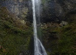
Hike Double Falls, South Falls, Silver Falls State Park, Oregon
Remote Double Falls, however, is listed as the highest waterfall in the park, plunging 178 feet (54 m) in a small tributary side canyon deep within the Silver Creek Canyon. Double Falls is the tallest of the waterfalls in Silver Falls State Park. It is located along the Trail of Ten Falls (mile 2.1 on the trail + 0.1 on side trail), along Canyon Trail, a few yards fr... -
Explore Doubtful Sound, Fiordland, New Zealand
Doubtful Sound is a very large and naturally imposing fiord (despite its name) in Fiordland, in the far south west of New Zealand. It is located in the same region as the smaller but more famous and accessible Milford Sound. It took second place after said Fiord as New Zealand's most famous tourism destination. Unlike the more easily accessible Milford Sound, it is no... -
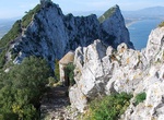
Hike Douglas Path, Gibraltar
Douglas Path is a path that connects a series of military installations at the top of the Rock of Gibraltar. It leads from the top of Charles V Wall to Mount Misery, one of the peaks of the Rock, before proceeding southwards to end at Douglas Cave. The first section of the path climbs a steep set of steps before running along a knife-edge ridge. It has views over both... -
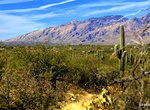
Hike or Ride Douglas Spring & Arizona Trail, Saguaro National Park, Arizona
Douglas Spring Trail is a long but easy trail that offer views of a waterfall at Bridal Wreath Falls. Just before reaching the Douglas Spring Campground the trail will merge with the Arizona Trail, The Douglas Spring Trailhead is located at the east end of Speedway Boulevard and is accessible 24 hours per day. Due to this easy access, vehicle break-ins have occurred a...


Price: $83.37