Give us feedback!


 See all

Our philosophy is simple. We want to encourage you to dream. BIG! Then we help you plan your trip, get the most out of it while you're traveling and help you share your experience with friends.
Join Now It's FREE
Dream Packages
Duration: 5 hours
Price: $106.33
Price: $106.33
Duration: 7 hours
Price: $144.00
Price: $144.00
Duration: 3 hours
Price: $140.24
Price: $140.24
Duration: 4 hours
Price: $120.43
Price: $120.43
Dreams Still To Do
Checked-Off Dreams
Dreams Still To Do
Checked-Off Dreams
Advertisement
Explore Adventure Sports
-
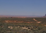
Hike Driskill Mountain, Bienville Parish, Louisiana
Driskill Mountain (also referred to as Mount Driskill) is the highest natural summit in Louisiana, with an elevation of 535 feet (163 m) above sea level. It lies about 5.3 miles (8.5 km) southeast of Bryceland, Louisiana. It is located in the northeastern corner of Sec. 32, T. 17 N., R. 5 W. within Bienville Parish. Driskill Mountain is a landform created by the erosi... -
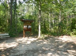
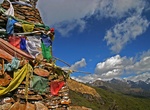
Do Druk Path Trek, Bhutan
The Druk Path Trek in Bhutan is a 4-6 day trek that starts in Paro (next to the National Museum) and ends in Motithang, which is about a 20 minute drive to the capital, Thimphu. There are several variations to the trek but the usual one is slightly under 60 km. The trek that passes through a gorgeous natural landscape of blue pine forests, high ridges and pristine l... -
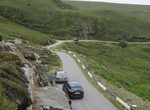
Drive Drumbeg Road (B869), Sutherland, Scotland
Drumbeg Road (B869) is a 35.4km (22 miles) long drive through the Assynt district of Sutherland in the Scotish Highlands. This picturesque route has stunning views of beaches, lochs, mountains and the sea. It's a paved road but very narrow and has steep hills and unexpected switchbacks. -
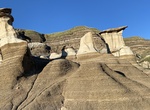
Hike to Drumheller Hoodoos (Willow Creek Hoodoos), Alberta, Canada
Popular hike through a unique landscape featuring otherworldly sandstone pillars with rock caps. Located near Drumheller. The Hoodoos Trail is a must see on any vacation through Central Alberta, Canada -
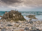
Visit Drumhollistan, Scotland
Dramatic sea cliffs and puffins. -
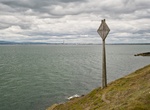
Hike to Drumleck Point Telegraph Cable Marker, Howth, Ireland
Some of the earliest Anglo-Irish telegraph cables were laid between Holyhead and Howth. In Howth, Dublin, Ireland. -
Hike Drunk Bay Trail, St John, USVI
The Drunk Bay Trail starts at Salt Pond Bay Beach on St John and offers hikes rugged beauty and great pictures. The trail starts at the eastern end of the beach. Go left to Drunk Bay (right goes to Ram Head). Once you get to Drunk Bay you wil find rugged coral and stone shoreline with visitor-created stone sculptures and cairn. It's a pretty short hile to Drunbk Bay b... -
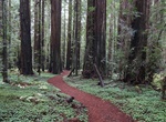
Hike Drury-Chaney Trail, Scotia, California
Located at the north end of Humboldt Redwoods State Park, cooler temperatures and more fog create a lush carpet of greenery under the lofty old-growth redwoods of the Drury-Chaney Loop. Start at Avenue of the Giants mile marker 43.9, just south of the town site of Pepperwood. -
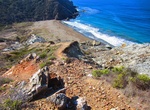
Hike Dry Creek Beach Trail to Ben Weston Beach, Catalina Island, California
Dry Creek Beach Trail is a hiking trail on the western side of Catalina Island that connects Middle Ranch Rd to Ben Weston Beach. -
Off-road Dry Fork - Coyote Gulch (Hole-in-the-Rock Road), Utah
To reach Dry Fork - Coyote Gulch drive from the town of Escalante, Utah for 5.0 miles east on Highway 12 to the signed Hole-In-The-Rock Roa. For here there is a good gravel road on the south side of Highway 12 that leads to the Hole-In-The-Rock Road. From here travel 26.3 miles to the signed Dry Fork Road. Turn east (left) and follow the Dry Forks Road 0.7 miles to ... -
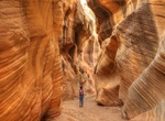
Hike Dry Fork Narrows, Coyote Gulch, Utah
The Dry Fork Narrows is an excellent example of how occasional flash floods have carved a narrow slot into the underlying Navajo Sandstone. While not technically a slot canyon because you can't touch both walls at the same time, the canyon walls are narrow and very tall bat approximately 20 feet (7 m) deep. The slot can be followed upstream for several hundred yards.... -
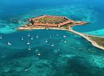
Explore Dry Tortugas National Park, Florida
Dry Tortugas National Park preserves Fort Jefferson and the Dry Tortugas section of the Florida Keys. The park covers 101 mi² , mostly water, about 68 statute miles west of Key West in the Gulf of Mexico. It is famous for abundant sea life, colorful coral reefs and legends of shipwrecks and sunken treasures. The park's centerpiece is Fort Jefferson, a massive but... -
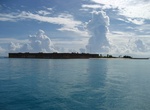
Kayak or Canoe Dry Tortugas National Park, Florida
Dry Tortugas National Park is one of the most beautiful marine areas to explore in the National Park Service. The Trip to this park is a commitment of time and visitors should plan how best to experience this unique place. If you're one who enjoys getting out on the water and exploring - Consider bringing along your own canoe or kayak. (There are no rentals available... -
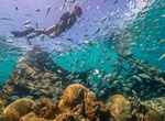
Snorkel Dry Tortugas National Park, Forida
The Dry Tortugas lies almost 70 miles west of Key West, Florida and offers some of the best snorkeling in the entire park service. -
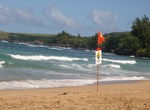
Relax at D. T. Fleming Beach Park, Kapalua, Maui, Hawaii
D. T. Fleming Beach Park in Kapalua is a quiet, out-of-the-way beach, located north of the Ritz-Carlton hotel next to the 16th hole of the Kapalua Golf Course.The beach is a favorite for body surfing, board surfing and swimming. Facilities include picnic tables, restrooms and lifeguards on duty.

Price: $109.14