Give us feedback!


 See all

Our philosophy is simple. We want to encourage you to dream. BIG! Then we help you plan your trip, get the most out of it while you're traveling and help you share your experience with friends.
Join Now It's FREE
Dream Packages
Duration: 4 hours
Price: $120.43
Price: $120.43
Duration: 3 hours
Price: $173.83
Price: $173.83
Duration: 2 days
Price: $469.00
Price: $469.00
Duration: 7 hours
Price: $179.00
Price: $179.00
Dreams Still To Do
Checked-Off Dreams
Dreams Still To Do
Checked-Off Dreams
Advertisement
Explore Adventure Sports
-
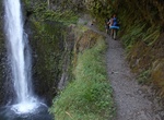
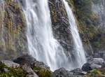
Hike Eagle Creek Falls Trail, Oregon
Punch Bowl Falls is a waterfall on Eagle Creek in the Columbia River Gorge National Scenic Area, Oregon, United States. Eagle Creek drains into the Columbia River, with its outlet on the Columbia River Gorge in Multnomah County. The falls is 35 feet (11 m) tall and 10 feet (3.0 m) wide. Eagle Creek cuts through a narrow channel and shoots powerfully into a large bowl ... -
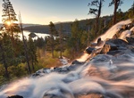
Hike to Eagle Falls & Eagle Lake, Lake Tahoe, California
The hike to Eagle Falls is a strenuous hike but well worth it. The 1.8 mile out and back trail located near Emerald Bay on Lake Tahoe. The views are breathtaking. Parking is pretty difficult and they fill up quickly. -
Hike to Eagle Lake, Sequoia National Park
Eagle Lake, a glacially carved tarn 3.4 miles (one way) from the west side of the Mineral King Valle trailhead. The right-hand trail ends at Mosquito Lake #1, 3.6 miles (one way) from the trailhead, but hikers and fishermen often continue up the drainage to the upper lake. -
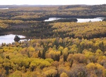
Hike Eagle Mountain, Grand Marais, Minnesota
Eagle Mountain is the highest natural point in Minnesota, at 2,301 feet (701 m). It is located in northern Cook County and is in the Boundary Waters Canoe Area Wilderness and Superior National Forest in the Misquah Hills, northwest of the community of Grand Marais. It is a Minnesota State Historic Site. Eagle Mountain is only about 15 miles (24 km) from Minnesota's lo... -
Dive Eagle Nest Sinkhole, Florida
NOTE: Eagle's Nest Sinkhole is an expert-level cave divign site in west central Florida inside the Chassahowitzka Wildlife Management Area (WMA). Numerious people have died in the cave system. Eagle's Nest is a deep cave system. The cave has been mapped to 310 feet deep. There are tunnels both upstream and downstream of the cave entrance. -
Hike Eagle Point Trail, Cathedral Gorge State Park, Nevada
Follows a ridge line to a bird’s-eye view of the entire park. -
Hike to Eagle Rock via Pacific Crest Trail (PCT), Warner Springs, California
Eagle Rock via the PCT is a 6.4 to 10 mile out and back trail located near Warner Springs, California. The 10 mile trailhead is located off Hwy 79 about a 1.5 miles past Warner Springs you will see a large turn out on the left side of the road. This is the 10 mile Trailhead for Eagle Rock, if you see the airfield you have gone to far. The Pacific Crest Trail is just ... -
Hike, Cycle or Drive Eagles' Nests Trail, Poland
The Trail of the Eagles' Nests of south-western Poland, is a marked trail, named after a chain of 25 medieval castles which the trail passes by, between Częstochowa and Kraków. The Trail of the Eagles' Nests was first marked by Kazimierz Sosnowski. Since 1980, much of the area has been designated a protected area known as the Eagle Nests Landscape Park. The cas... -
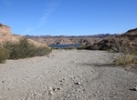
Drive Eagle Wash Road, Nevada
Eagle Wash Road is a great run for those looking for a short, easy drive with scenic views of the surrounding desert and mountains. The road ends at a cove on the Colorado River. This is a great place for swimming or other water activities during the summer. Eagle Wash Road is connected to several trails that can be explored at the same time. TIPS: 4WD recommended... -
Hike Eardley Canyon, San Rafael Swell, Utah
Eardley Canyon is north of Goblin Valley along Utah State Route 24. This trail is usually uncrowded and access to technical canyoneering routes. Non-technical hikers can hike 2.5 miles to the Amazing Pool with out gear. 100-yards beyond the "No Vehicles beyond this point" signs there are two very good petroglyph panels on the right side of the canyon. Eardley Canyon... -
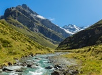
Hike to Earland Falls (Routeburn Track), New Zealand
The hike to Earland Falls is a fabulous, easy day walk on the Routeburn Track. There are plenty of mountain and valley views along the way. The trails starts at The Divide carpark and follows the Routeburn Track. -
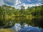
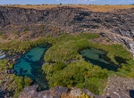
Explore Earl M. Hardy Box Canyon Springs Nature Preserve, Thousand Springs State Park, Idaho
This 350-acre (140 ha) box canyon has 250-foot-high (76 m) walls. At its head is the eleventh-largest spring in North America, gushing 180,000 US gallons (680,000 L) per minute. There is a 20-foot (6.1 m) waterfall. The 350-acre (140 ha) property was developed by the Nature Conservancy which purchased the site in 1999, then completed its transfer to the state in 2016.... -
Hike Earnslaw Burn Track, Glenorchy, New Zealand
Following Earnslaw Burn through bush to the tussock basin at the head of this valley for impressive views of an icefall on Mt Earnslaw/Pikirakatahi. Follow the Earnslaw Burn Track through the bush to a viewpoint. This viewpoint has impressive views of an icefall on Mt Earnslaw/Pikirakatahi at the edge of the forest where the track ends. For shelter an overhanging roc... -
Hike Earthquake Trail, Point Reyes National Seashore, California
The Earthquake Trailhead is located at the northeast end of the Bear Valley Trailhead parking lot. The Earthquake Trail is a 0.6-mile-long (1-kilometer-long) nature trail with exhibits about the San Andreas Fault Zone and the 1906 San Francisco Earthquake. -
Surf Easkey, Sligo, Ireland
The beach at Easkey near Sligo, Ireland is legendary for clean waters and great surfing.


Price: $180.00