Give us feedback!


 See all

Our philosophy is simple. We want to encourage you to dream. BIG! Then we help you plan your trip, get the most out of it while you're traveling and help you share your experience with friends.
Join Now It's FREE
Dream Packages
Duration: 8 hours
Price: $220.83
Price: $220.83
Duration: 2 days
Price: $469.00
Price: $469.00
Duration: 4 hours 30 minutes
Price: $176.03
Price: $176.03
Duration: 3 hours 30 minutes
Price: $99.36
Price: $99.36
Dreams Still To Do
Checked-Off Dreams
Dreams Still To Do
Checked-Off Dreams
Advertisement
Explore Adventure Sports
-
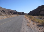
Drive Emigrant Canyon Road, Death Valley National Park, California
Emigrant Canyon Road is a 21.5 mile paved road in Death Valley National Park. The road provides access to Skidoo, Aguereberry Point, and Wildrose roads. Highway 178 (east) Watch for potholes in pavement. Subject to flooding in heavy rains. RVs, trailers, and buses over 25 ft. not allowed due to narrow canyon and roadway. -
Wreck Dive Emily (Kawanishi H8K1) Flying Boat, Chuuk Lagoon, Micronesia
Wreck Dive the Emily (Kawanishi H8K1) Flying Boat in Chuuk Lagoon. Map location is only an approximate location of the wreck. -
Ride Emirates Air Line Gondola Lift, London
The Emirates Air Line (also known as the Thames cable car) is a gondola lift link across the River Thames in London built by Doppelmayr with sponsorship from the airline Emirates. The service opened on 28 June 2012 and is operated by Transport for London. It has an average ridership of 31,601 passenger journeys a week but is used by only four regular commuters. The se... -
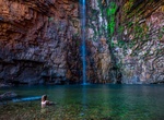
Hike Emma Gorge to Emma Pools & Falls, El Questro Wilderness Park, Kimberley, Western Australia
One of Australias best swimming spots, Emma Gorge, is a haven surrounded by untamed beauty where you can float away and escape for a moment. -
Hike Emma Long Park Turkey Creek Trail, Austin, Texas
Turkey Creek Trail is a 2.8 mile moderately trafficked out and back trail located near West Lake Hills, Texas that features a river and is rated as moderate. The trail offers a number of activity options and is accessible year-round. Dogs are also able to use this trail. -
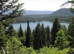
Hike Emma Matilda Lake Trail, Grand Teton National Park
The Emma Matilda Lake Trail is a 10.7-mile (17.2 km) long hiking trail in Grand Teton National Park in the U.S. state of Wyoming. The trail is best accessed from Jackson Lake Lodge but can also be accessed from the Two Ocean Lake trailhead. The Emma Matilda Lake Trail loops completely around Emma Matilda Lake, and provides views of the lake and the entire Teton Range.... -
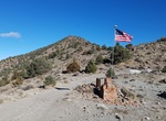
Explore Emma Peak, Nevada
Emma Peak is located in the Flowery Range in Northwest Nevada. It is the highest point on the Flowery Ridge, a 5-mile long ridge east of Virginia City. Emma Peak is actually on the south side of Six Mile Canyon Road, and follow a parallel ridge heading east. -
Hike on Emmons Glacier, Mount Rainier National Park
Emmons Glacier is on the northeast flank of Mount Rainier, in Washington. At 4.3 sq mi (11 km2), it has the largest surface area of any glacier in the contiguous United States. The glacier was named after the geologist Samuel Franklin Emmons after his involvement in a survey of Mount Rainier in 1870. Starting at an elevation of over 13,800 ft (4,200 m), the Emmons gla... -
Visit Enchant Christmas, Arlington, Texas
Enchant is the creator of the The World's Largest Christmas Light Maze - now with experiences in both Arlington, Texas and Seattle, Washington that are unique to each event. The event is also host to a bustling artisan Christmas Market, an Ice Skating Trail, seasonal food and beverage, visits with Mr. and Mrs Claus, as well as exciting VIP and group experiences. It&rs... -
Drive Enchanted Circle Scenic Byway, New Mexico
The Enchanted Circle Scenic Byway is a New Mexico Scenic Byway and National Forest Scenic Byway located in Northern New Mexico. It begins and ends in Taos, New Mexico. The 84-mile (135 km) Enchanted Circle Scenic Byway makes a loop through Taos following four main highways: U.S. Route 64 between Eagle Nest and Taos NM 522 between Taos and Questa NM 38 between Questa,... -
Swim in Enchanted River (Hinatuan River), Philippines
The Hinatuan River is a river on the island of Mindanao in the Philippines. It flows into the Pacific Ocean at Hinatuan, Surigao del Sur. The River is also referred to as the "Enchanted River" by many locals and tourists. It is a salt water river and the river flows from a very deep pool (approx. 50 feet deep). It is near the ocean and the deep spring from which the w... -
Explore Enchanted Rock State Natural Area, Texas
Enchanted Rock is an enormous pink granite pluton rock formation located in the Llano Uplift approximately 15 miles (24 km) north of Fredericksburg, Texas, USA and 15 miles (24 km) south of Llano, Texas. Enchanted Rock State Natural Area, which includes Enchanted Rock and surrounding land, spans the border between Gillespie County and Llano County, south of the Llano ... -
Experience Encounter Kaikoura , Kaikoura, New Zealand
Dolphin watching tours and swimming with dolphins in Kaikoura, New Zealand. One of Kaikoura's top attractions and adventures. -
Visit Enderbury Island, Kiribati
Enderbury Island (Ederbury Island, Guano Island) is a small, uninhabited atoll 63 km ESE of Kanton Island in the Pacific Ocean. It is about 1 mile (1.6 km) wide and 3 miles (4.8 km) long, with a reef stretching out 60–200 metres. The island is now a possession of the Republic of Kiribati. The island is flat and bare, with elevations between 15 and 22 feet. Veget... -
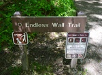
Hike Endless Wall Trail, New River, West Virginia
The Endless Wall Trail is a 2.4 mile moderate walk that passes through rich forest, crosses Fern Creek, then zig-zags along the cliff edge. Many vistas can be seen along the trail. The overlook at Diamond Point provides a good turnaround spot, creating a popular two-mile out-and-back hike from Fern Creek parking area. If you continue to the end of the trail, you will ...


Price: $180.00