Give us feedback!


 See all

Our philosophy is simple. We want to encourage you to dream. BIG! Then we help you plan your trip, get the most out of it while you're traveling and help you share your experience with friends.
Join Now It's FREE
Dream Packages
Duration: 4 hours
Price: $120.43
Price: $120.43
Duration: 6 days
Price: $606.00
Price: $606.00
Duration: 7 hours
Price: $144.00
Price: $144.00
Duration: 8 hours
Price: $208.72
Price: $208.72
Dreams Still To Do
Checked-Off Dreams
Dreams Still To Do
Checked-Off Dreams
Advertisement
Explore Adventure Sports
-
Dive Enewetak Atoll, Marshall Island
Enewetak Atoll (Eniwetok Atoll) is a large coral atoll of 40 islands in the Pacific Ocean, and forms a legislative district of the Ralik Chain of the Marshall Islands. Its land area totals less than 5.85 square kilometres (2.26 sq mi), surrounding a deep central lagoon, 80 kilometres (50 mi) in circumference. In November 1942, the Japanese built an airfield on Engebi ... -
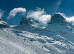
Ski or Snowboard Engelberg, Switzerland
The village of Engelberg is the foremost and largest ski resort in Central Switzerland’s Urner Alps Mountains. The main ski area of Engelberg, Titlis, the highest elevation resort in Switzerland, is famous for its off-piste terrain attracting advanced skiers from throughout the world. The area is known for dependable and prolific snow collection with a typical s... -
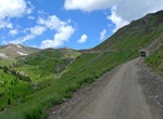
Off-road Engineer Pass Road, Colorado
This trail, combined with Cinnamon Pass, constitutes the famous Alpine Loop. Engineer Pass Road is a 20.5 mile point-to-point trail located near Ouray, Colorado. There are many waterfalls, mines and points of historical interest along the route. 4x4 high clearance vehicle is almost always required to do this road. -
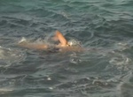
Swim Across English Channel
On August 25, 1875 Captain Matthew Webb of the British Merchant Navy was the first person to swim the English Channel without the use of artificial aids. He swam the 34 kilometers (21 miles) from Dover, England to Calais, France in the Strait of Dover in less than 22 hours. In the 1920’s the Channel Swimming Association (CSA) was formed to authenticate the swimm... -
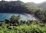
Visit Englishman's Bay, Tobago
Englishman's Bay is a secluded beach on the leeward coast of Tobago, between Castara and Parlatuvier. Although the bay does not draw the large numbers of beachgoers that Tobago's western beaches do, it is considered of the island's most beautiful. The beach itself is a classic crescent shape, capped by two heavily forested headlands descending from Tobago's Main Ridge... -
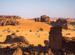
Explore Ennedi Massif, Chad (UNESCO Site)
The Ennedi Plateau, located in the North-East of Chad, in the Ennedi Region, is a sandstone bulwark in the middle of the Sahara. It is assailed by the sands on all sides, that encroach the deep valleys of the Ennedi. Only the caravans manage to cross it and this makes the region an area subject to multiple influences. The landscape has structures like towers, pillars,... -
Snorkel Enseada do Guriri, Arraial do Cabo, Brazil
Enseada do Guriri has water 3 to 5 meters deep. Great place to snorkel with sea turtles. -
Hike Entrada Canyon Trail, Goblin Valley State Park, Utah
The Entrada Canyon Trail begins at the group campsite and ends at the Valley of Goblins observation point parking lot. The canyon is named for the same layer of sand and silt stone that makes up the Valley of Goblins. For those spending the night in the park, it serves as a scenic alternative to driving. Along the way, hikers will pass by a number of interesting gobli... -
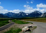
Drive Entrance Parkway, Waterton Lakes National Park, Alberta, Canada
The Entrance Parkway is an 8 km route from the Maskinonge wetlands, past the park gate to the Waterton Lakes townsite and provides scenic views overlooking the Waterton Valley. It starts out on the prairie and follows the Waterton Lakes chain past the Prince of Wales Hotel National Historic Site to the townsite. It is one of the best roads in the park for viewing wild... -
Hike Eorimok Trail, Hallasan National Park, Jeju Island, South Korea
Eorimok Trail (6.8 km) starts from Hallasan National Park’s Visitors center (altitude 970 m) and finishes at the South cliff junction (altitude 1.600 m). It takes about 3 hours for a one way trip. Recommend crampons for the Eorimok trail in the winter as it can be icy. -
Stand on the Equator
An equator is the intersection of a sphere's surface with the plane perpendicular to the sphere's axis of rotation and midway between the poles. The Equator usually refers to the Earth's equator: an imaginary line on the Earth's surface equidistant from the North Pole and South Pole, dividing the Earth into the Northern Hemisphere and Southern Hemisphere. Other planet... -
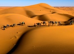
Explore Erg Chebbi Dunes, Morocco
Erg Chebbi is one of Morocco's two Saharan ergs – large dunes formed by wind-blown sand –. The other is Erg Chigaga near M'hamid. Its distinctive dunes reach a height of up to 150 meters. The composite erg spans an area of 22 kilometers from north to south and up to 5 kilometers from east to west. The nearest sizable town is Erfoud, about 40 kilometers fur... -
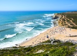
Surf Ericeira, Portugal
Ericeira is a civil parish and seaside community on the western coast of Portugaly, located 35km northwest of the center of Lisbon, about 45km by road. It is considered the surfing capital of Europe. It is also one of only two European spots among the World Surfing Reserves because of its exceptional coastline conditions. Ericeira was a popular summer retreat for many... -
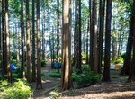
Kayak to Ericson's Bay Campground, Olympic National Park, Washington
Ericksons Bay is a prim ative campground is located on Lake Ozette in Olympic National Park. -
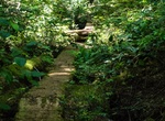
Hike Ericson's Bay Primitive Trail, Olympic National Park, Washington
Ericson's Bay Primitive Trail is not maintained and can only be accessed by boat from the east side of Ericson's Bay and the trail south of Sand Point. The trail cannot be accessed from the Ericson's Bay Camp. Permits/Reservations: Obtain permits at the Wilderness Information Center (WIC) in Port Angeles. Reservations required if you are camping on the beaches betwee...

Price: $83.37