Give us feedback!


 See all

Our philosophy is simple. We want to encourage you to dream. BIG! Then we help you plan your trip, get the most out of it while you're traveling and help you share your experience with friends.
Join Now It's FREE
Dream Packages
Duration: 8 hours
Price: $220.83
Price: $220.83
Duration: 8 hours
Price: $208.72
Price: $208.72
Duration: 7 hours
Price: $144.00
Price: $144.00
Duration: 6 days
Price: $606.00
Price: $606.00
Dreams Still To Do
Checked-Off Dreams
Dreams Still To Do
Checked-Off Dreams
Advertisement
Explore Adventure Sports
-
Visit Honeymoon & Salomon Beaches (St John), USVI
Salomon and Honeymoon Beaches off Saloman Bay offer two white-sand beaches with a nice snorkeling reef in between them. The beaches are a short hike from the Virgin Islands National Park sign off North Shore Rd. In the clear water off the rocky point in between the two beaches, you will find several species of coral (brain, lettuce leaf, elkhorn, mustard hill, and pi... -
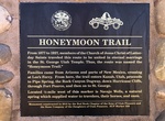
Hike Honeymoon Trail, Utah & Arizona
The Honeymoon Trail During the late 19th and early 20th centuries, a primitive wagon road was the principle travel route between the Mormon settlements in northeastern Arizona and southern Utah. In the late 1870s, Mormon colonists had been sent by church leaders to pioneer new settlements along Arizona’s Little Colorado River. As the new settlements were remote ... -
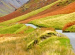
Drive Honister Pass, Lake District National Park, England
Honister Pass is a mountain pass in the Lake District in Cumbria, England. It is located on the B5289 road, linking Seatoller, in the valley of Borrowdale, to Gatesgarth at the southern end of Buttermere. The pass reaches an elevation of 1,167 feet (356 m), making it one of the highest in the region, and also one of the steepest, with gradients of up to 1-in-4 (25%). ... -
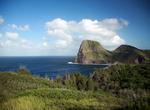
Drive Honoapiilani & Kahekili Highways (Routes 30 & 340),, North Side of West Maui, Hawaii
The Honoapiilani Highway (Route 30) is a road on West Maui, Hawaii. It begins in downtown Wailuku, extending south through Waikapu and Maalaea. Following terrain of the island it circumvents the West side of West Maui connecting Olowalu, Launiupuko, Lahaina, Kahana, through the regions of Kapalua and Honolua, and ending in Honokohau Bay. At this point the road continu... -
Snorkel Honokeana Bay, Maui, Hawaii
Honokeana Bay is a rocky cove next to Napili Beach on Maui is a great place to swim with a LOT of Sea Turtles. The bay is surrounded by resorts and access is not easy. You can walk from Napili Beach and there are afew rocky places to enter the water (no beach). Be careful getting in and out. Take just snorkel equipment as there is nowhere to leave a lot of stuff, jus... -
Hike to Honokōhau Beach via Ala Mauka-Makai Trail, Big Island, Hawaii
Honokōhau Beach on the Big Island of Hawaii is part of Kaloko-Honokōhau National Historical Park. Stretching north from Honokohau Boat Harbor, the striking white coral sand of Honokohau Beach contrasts sharply against the black lava. Numerous sea turtles frequent the beach to feed on the limu (algae) and bask along the shore. An ancient heiau (temple) stands at the e... -
Dive or Snorkel Honolua Bay, Maui, Hawaii
Honolua Bay, Mokuleʻia Bay and Lipoa Point are part of an area known as the ahupuaʻa of Honolua, located just north of Kapalua, West Maui in Maui County, Hawaiʻi, United States. The area is a mix of agricultural and conservation land tended by the Maui Land & Pineapple Company in Lahaina, Hawaiʻi, including coastline management. Honolua Bay and Mokuleʻia Bay compr... -
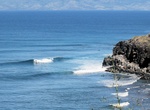
Surf Honolua Bay, Maui, Hawaii
The surf at Honolua Bay in the Winter is nice clean, hollow, powerful wave offers the chance at some really long rides. Also during the winter you can watch whales crusing by in between sets. Honolua Bay hosts the annual “Billabong Pro” women's surf competition in December. Sightseers can watch from the bluffs above the bay to watch the pros from a safe d... -
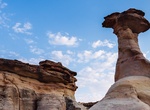
Hike Hoodoo Trail, Ojito Wilderness, New Mexico
The Hoodoo Trail is a 3.4 mile out and back trail in the Ojito Wilderness. From Bernalillo, travel on U.S. 550 about 21 miles (about 2 miles before San Ysidro) turning left onto Cabezon Road (County Road 906). Follow the left fork approximately 9 and 1/4 miles to an Ojito Wilderness sign. Continue about 1 3/4 mile to a developed parking area on the left side of the r... -
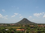
Summit Hooiberg (Haystack Mountain), Aruba
Hooiberg is a 165 m (541 ft) high volcanic formation on the island of Aruba. It is located almost in the center of the island and can be seen from virtually anywhere on the island. The haystack is in the center of the country and provides a breathtaking view of Aruba. People suggest going on a cool & clear day because it will be easier to climb the 561 steps requi... -
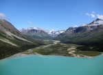
Hike Hooker Valley Track, New Zealand
The Hooker Valley Track is the most popular short walking track within the Aoraki/Mount Cook National Park in New Zealand. At only 5 kilometres (3.1 mi) length and gaining only about 100 m (330 ft) in height, the well formed track can be walked by tourists with a wide range of level of fitness. The track is maintained by the Department of Conservation and its main att... -
Windsurf or Kitesurf Ho'okipa on Maui, Hawaii
Even if Windsurfing didn’t originate in Hawaii the islands are considered home to the sport. The surface water sport was refined in the mid 1960’s by an aeronautical designer and a traditional wave surfer in California but far and away finds its greatest participation and following in Hawaii. You can travel to Maui’s Hookipa Beach which is considered... -
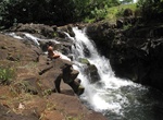
Hike to Ho'opi'i Falls, Kauai, Hawaii
Hoʻopiʻi Falls are a series of waterfalls along the Kapaʻa Stream, located near the Kapaʻa town on the east shore of Kauai. The 2.2-mile trail can be a bit tricky to find. The trailhead is at a dirt path guarded by an old metal gate covered in shrubbery. The falls were used as a filming location in Jurassic Park (1993) for the fictional site of the "Mano de Dios ... -
Hike Hoosier Hill, Franklin Township, Indiana
Hoosier Hill is the highest natural point in the state of Indiana at 1,257 feet (383 m) above sea level. It is in the rural area of Franklin Township, Wayne County to the northwest of Bethel. The nearest intersection to the high point is Elliot Road and County Line Road. The nearest major landmark is Interstate 70 and Richmond 11 miles (17.5 km) to the south. The Hill... -
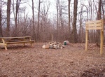
Hike Hope Creek Valley, Lake Clark National Park, Alaska
An excellent day hike from Upper Twin Lake, the Hope Creek Valley trail climbs through a verdant, wild landscape to the untold beauty beyond. With impressive, jagged peaks emerging through the clouds and the sound of Hope Creek rushing below, spend the day relaxing in the splendor of Richard Proenneke's wilderness or hike into the unknown through this expansive alpine...


Price: $99.36