Give us feedback!


 See all

Our philosophy is simple. We want to encourage you to dream. BIG! Then we help you plan your trip, get the most out of it while you're traveling and help you share your experience with friends.
Join Now It's FREE
Dream Packages
Duration: 7 hours
Price: $144.00
Price: $144.00
Duration: 3 hours
Price: $173.83
Price: $173.83
Duration: 4 hours
Price: $120.43
Price: $120.43
Duration: 3 hours 30 minutes
Price: $99.36
Price: $99.36
Dreams Still To Do
Checked-Off Dreams
Dreams Still To Do
Checked-Off Dreams
Advertisement
Explore Adventure Sports
-
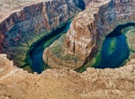
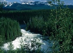
Hike to Horseshoe Bend, Arizona
Horseshoe Bend is the name for a horseshoe-shaped meander of the Colorado River located near the town of Page, Arizona within Glen Canyon National Recreation Area. The bend is locally known as "King Bend." The bend is a ccessible via a hike from U.S. Route 89, it can be viewed from the steep cliff above. The overlook is about 1,000 feet (300 m) above the river. The 1... -
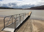
Visit Horseshoe Bend Campground & Marina, Bighorn Canyon National Recreation Area, Wyoming
Uphill from the Horseshoe Bend Marina and picnic area, nestled in sagebrush and juniper woodland communities, the 48 campsites of the Horseshoe Bend Campground overlook the Bighorn Lake and the red sandstone cliffs of Sykes Mountain. The campground is located 14 miles north of Lovell, Wyoming via WY Hwy 37.During the winter of 2007-08 Bighorn Canyon employees, using f... -
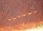
Hike to Horseshoe Bend Petroglyphs, Colorado River, Arizona
The trail starts at a sandy beach at Colorado River mile nine (north of Lee's Ferry) at the bottom of scenic Horseshoe Bend in Glen Canyon. The trailhead is only accessible via boat on the Colorado River. There are two pit toilets on the north side of the trail just above the beach. The first way to get to the trailhead is going upstream in a shallow-draft boat from t... -
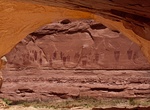
Hike to Horseshoe Canyon (Great Gallery), Canyonlands National Park, Utah
Horseshoe Canyon, formerly known as Barrier Canyon, is in a remote area west of the Green River and north of the Canyonlands National Park Maze District in Utah, USA. It is known for its collection of Barrier Canyon Style (BCS) rock art, including both pictographs and petroglyphs, which was first recognized as a unique style here. A portion of Horseshoe Canyon contain... -
Hike to Horseshoe Falls (Wells Gray Provincial Park), British Columbia, Canada
Horseshoe Falls is one of seven waterfalls on the Murtle River west of Murtle Lake in Wells Gray Provincial Park, east-central British Columbia, Canada. Horseshoe Falls has two steps, 100 m (328 ft) apart; the upper drop is 6 m (20 ft) high and the lower and much wider drop is 10 m (33 ft) high. Horseshoe Falls can be reached by a 14 km (8.7 mi) hiking trail from Pyra... -
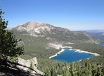
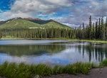
Explore Horseshoe Lake, Mammoth Lakes, California
Horseshoe Lake is located just south of Mammoth Lakes, California. Leave Hwy 395 at Mammoth Lakes, Hwy 203 and follow Lake Mary Road. Follow the signs to Horseshoe Lake. -
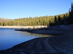
Visit Horseshoe Lake, Washington State
Horseshoe Lake is a lake situated in the east side of the Midway High Lakes Area below Mount Adams' northwest flank. The lake is popular for camping, quiet boating (electric motors or canoeing), and hiking and biking on a trail halfway around the lake. Other activities include scenic viewing and fishing. The lake offers an eleven-site campground, administered by the G... -
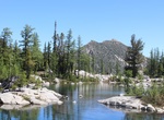
Ride or Hike Horseshoe Lake Loop, Mammoth Lakes, California
The Horseshoe Lake Loop in Mammoth Lakes, California is a family friendly 2.1 mile hiing or mountain bike loop around Horseshoe Lake. Start off at the parking lot at the end of Lake Mary Road. It begins on a gently rolling dirt trail. Once you get to the end of Path jump onto Lakes Basin Bike Path that goes along Lake Mary Road. -
Hike Horseshoe Lake Trail, McKinley Park, Alaska
This popular trail starts at Mile0.9 near the railroad tracks along the park route. Walk down to the lake on a trail that has been created. The trail descends steeply after you reach the Overlook. You'll have a panoramic view of the Nenana River along the way, particularly at the overlook bench. -
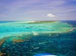
Dive Horseshoe Reef, Anegada, BVI's
Anegada is known for miles of white sand beaches and the 18-mile (29 km)-long Horseshoe Reef, the largest barrier coral reef in the Caribbean, and the fourth largest on earth. The reef has hundreds of wrecks that creates outstanding diving. The reef is also home to some of the best lobster in the BVI's. The reef makes navigation to Anegada difficult. While charter boa... -
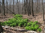
Hike or Ride Horse-Shoe Trail, Pennsylvania
The Horse-Shoe Trail is a 140-mile (230 km) trail that runs from the western edge of Valley Forge National Historical Park westward toward Harrisburg, Pennsylvania. It ends about 15 miles northeast of Harrisburg at the Appalachian Trail. The trail was developed for equestrian and pedestrian use, according to the Horse-Shoe Trail Club guide, hence the name (horse + sho... -
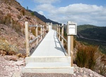
Hike to Horsetail Falls, Tasmania, Australia
Horsetail Falls is a seasonal waterfall near Queenstown, Tasmania. The falls cascades over 50 metres down a steep cliff face, and can be seen from the road. A boardwalk giving closer access was opened in 2017. -
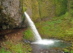
Hike Horsetail Falls Trail, Oregon
Horsetail Falls Trail is an easy 2.6 miles trail along the Columbia River Gorge in Oregon. There are actually two waterfalls along the creek. The upper falls, called Upper Horsetail Falls or Ponytail Falls, can be accessed from a footpath. The waterfall is easily accessed, in contrast to its near neighbor Oneonta Falls, as it is right next to the Historic Columbia Ri... -
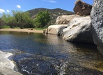
Hike Horsethief Canyon, Alpine, California
Horsethief Canyon is about 3.3 miles long and located near Alpine, California. The trail is great for hiking and normally takes 1-3 hours. This is a great, short hike down to a small swimming hole surrounded by rocks. Connects to the Pine Creek Wilderness, the Secret Canyon Trail, and the Espinoza Trail. -
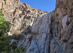
Hike Horse Thief Canyon, Arizona
Description: This canyon is rumored to be named after Horse Thief Ranch--a ranch several noted outlaws reportedly made headquarters for the trafficking of stolen horses. Located down a 4WD dirt road, it passes numerous granite water slides and huge cottonwood trees. At the entrance to the hike, there is a granite slide--a tall ledge where water would flow if there wer...
Price: $149.00