Give us feedback!


 See all

Our philosophy is simple. We want to encourage you to dream. BIG! Then we help you plan your trip, get the most out of it while you're traveling and help you share your experience with friends.
Join Now It's FREE
Dream Packages
Duration: 8 hours
Price: $220.83
Price: $220.83
Duration: 2 days
Price: $242.00
Price: $242.00
Duration: 3 hours
Price: $180.00
Price: $180.00
Duration: 4 hours 30 minutes
Price: $176.03
Price: $176.03
Dreams Still To Do
Checked-Off Dreams
Dreams Still To Do
Checked-Off Dreams
Advertisement
Explore Adventure Sports
-
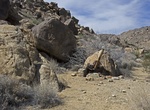
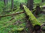
Hike to Johns Camp & Gold Hill Mine, Joshua Tree National Park, California
Johns Camp existed because of five claims collectively known as the Gold Hill Mine, located a little farther up the wash from the camp. The mine operated during the late 1920s and early 1930, and was owned by C.H. Wiser, Anvil B. Johns and J.A. Johns. I'm guessing the camp was named after one of the Johns. There's no trail to Johns Camp, but there is a fading dirt ro... -
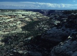
Hike John's Canyon, Utah
Access to the lower end of John’s Canyon is via Utah Highway 261 from the turn off to Goosenecks State Park. One can drive the dirt road along the north rim of the San Juan River, up to a drill pad near the mouth of John’s Canyon. The upper part of John’s Canyon can be entered from a dirt road off Highway 261, via a side canyon just south of the dril... -
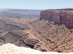
Off-road John's Canyon Road (244), Utah
The route follows an old road which parallels the San Juan river on a large bench several hundred feet above the river and several hundred feet below the top of Cedar Mesa. The John's Canyon Road (244)is located near Mexican Hat, Utah. The road skirts the base of Cedar Mesa between Cedar Point and the Slickhorn Canyon complex. Also goes below Muley Point. -
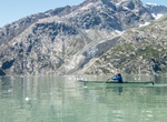
Kayak Johns Hopkins Inlet, Aslaka
Glacier Bay National Park’s scenic West Arm includes the pristine wilderness of John Hopkins Inlet. -
Hike John's Lake Trail, Glacier National Park, Montana
Johns Lake Loop is a 1.9 mile loop trail near Lake McDonald in Glacier National Park. -
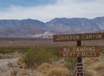
Off-road & Hike Johnson Canyon Road to Hungry Bill's Ranch, Death Valley National Park, California
Johnson Canyon is a fun side trail off West Side Road in Death Valley National Park. High-clearance is recommended for the first 6 miles which is pretty flat, but the last 4 miles require 4WD as it goes up the canyon. Last 0.1 mile of road is over-grown and very wet. Johnson Canyon Rd ends at a steep 2-mile hike leads to Hungry Bill's Ranch, with its rock-walled terra... -
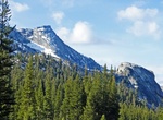
Summit Johnson Peak, Tuolumne Meadows, California
Johnson Peak is the highest mountain, in Tuolumne Meadows, Yosemite National Park. Johnson Peak is made of eroded granite. At 85 Ma, the Johnson Granite Porphyry is the youngest granite rock in the Yosemite National Park, though the entire peak formed beneath the Earth's crust. It broached the surface much later, via subduction. Despite it being a fairly easy hike, Jo... -
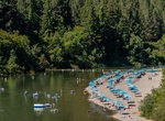
Visit Johnson's Beach, Guerneville, California
A Russian River tradition, Johnson’s Beach is a favorite summer spot for locals and visitors alike. -
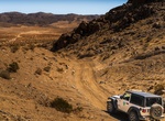
Off-road Johnson Valley OHV Area, Landers, California
Johnson Valley is a varied landscape for the off-highway vehicle driver. It is punctuated by steep red rocky mountains, rolling hills, open valley, dry lake beds and sandy washes. Elevations range from 4,600 feet at Hartwell Hills to 2,300 feet at Melville Dry Lake. Vegetation consists of creosote scrub, annual grasses, wild flowers and Joshua Trees. Johnson Valley of... -
Visit Johnston Atoll National Monument
Johnston Atoll is a 1.03 sq mi (2.7 km2) atoll in the North Pacific Ocean about 750 nmi (860 mi; 1,390 km) west of Hawaii. Johnston Atoll is a National Wildlife Refuge and is closed to public entry. Limited access for management needs is only by Letter of Authorization from the U.S. Air Force and Special Use Permit from the U.S. Fish and Wildlife Service. There are fo... -
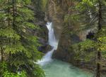
Hike Johnston Canyon & Waterfalls, Banff National Park, Canada
Johnston Creek is a tributary of the Bow River in Canada's Rocky Mountains located in Banff National Park. As Johnston Creek approaches the Bow River, it flows through a large canyon formed by erosion over thousands of years. The creek has cut through the limestone rock to form sheer canyon walls, as well as waterfalls, tunnels, and pools. This popular tourist attract... -
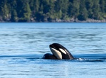
Kayak with Whales in Johnstone Strait, BC, Canada
Imagine waking one morning to the sound of a humpback whale's blow as it swims past your ocean side tent. Later that same day watch in awe as a pod of killer whales, also known as orcas, swim past your kayak as a bald eagles swoops down to catch a salmon. There is no better place in the world to kayak with both killer whales and humpback whales than Johnstone Strait ... -
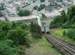
Ride Johnstown Inclined Plane, Pennsylvania
The Johnstown Inclined Plane is a 896.5-foot (273.3 m) funicular in Johnstown, Cambria County in the U.S. state of Pennsylvania. The incline and its two stations connect the city of Johnstown, situated in a valley at the confluence of the Stonycreek and the Little Conemaugh Rivers, to the borough of Westmont on Yoder Hill. The Johnstown Inclined Plane is billed as the... -
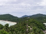
Hike to John Suwan Viewpoint, Ko Tao, Thailand
In order to reach the viewpoint you have to hike for 15-20 minutes in mediocre path. There are some rocks to climb but mostly there'll be ropes for extra support. You'll have to fight the sun and humidity too but once you're at the top you'll forget it all. The view is the best on the island! -
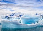
Explore Jökulsárlón Glacial Lagoon, Iceland
Jökulsárlón ("glacial river lagoon") is a large glacial lagoon in southeast Iceland, on the borders of Vatnajökull National Park. Situated at the head of Breiðamerkurjökull, it evolved into a lagoon after the glacier started receding from the edge of the Atlantic Ocean. The lake has grown since then at varying rates because of melting ...
Price: $140.24