Give us feedback!


 See all

Our philosophy is simple. We want to encourage you to dream. BIG! Then we help you plan your trip, get the most out of it while you're traveling and help you share your experience with friends.
Join Now It's FREE
Dream Packages
Duration: 2 days
Price: $469.00
Price: $469.00
Duration: 6 days
Price: $606.00
Price: $606.00
Duration: 15 hours
Price: $149.00
Price: $149.00
Duration: 5 hours
Price: $106.33
Price: $106.33
Dreams Still To Do
Checked-Off Dreams
Dreams Still To Do
Checked-Off Dreams
Advertisement
Explore Adventure Sports
-
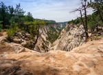
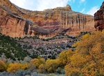
Hike Jolley Gulch, Zion National Park, Utah
This unmistakable canyon seems to drop out beneath your feet as you see it from the trail. Located a couple miles from the East Rim Trailhead. It marks a great turn around point for a shorter day hike from the East Entrance and back. Or continue on the East Rim Trail. -
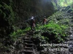
Explore Jomblang Cave, Indonesia
Jomblang is one of over 500 hundreds of cave complex in Gunungkidul karst that becomes well known because of its uniqueness. Jomblang Cave is a vertical cave whose depths vary with the deepest is around 80 meters with dense ancient forest below. To enter Jomblang cave, we need to master single rope technique (SRT). Everyone who wish to do caving in this place should ... -
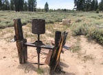
Walk to Jonathan Tibbetts' Grasshopper Quartz Mill, Holcomb Valley, California
Jonathan Tibbetts' Grasshopper Quartz Mill is stop 4 of the Gold Fever Trail near Big Bear Lake. It's includes a few small pieces of equipment from what was once a stamp mill. It's about 300 yard walk to the site. -
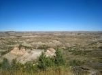
Hike Jones Creek/Lower Talkington/Lower Paddock Loop, Theodore Roosevelt National Park, North Dakota
This loop combines the Jones Creek Trail, the Lower Talkington Trail, and the Lower Paddock Creek Trail. Add it to the Upper Paddock/Talkington Loop for an epic adventure of 23.4 miles. -
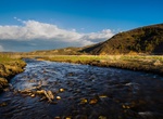
Hike Jones Hole Trail, Dinosaur National Monument, Utah
A pleasant hike along a babbling brook in the bottom of a lovely canyon. It's 8½ mile round trip which does not include the side trip to Ely Creek Falls. Basically level walking with a few ups and downs. Quite a bit of shade. Trail terminates at the Green River. Approximately 1½ miles down the trail from the fish hatchery are several panels of Fremont pe... -
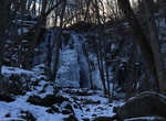
Hike to Jones Run Falls, Shenandoah National Park, Virginia
Located at mile 84.1 in the South District of the park. Do you want a waterfall that will soothe your spirit and bring you peace? Try this one. The hike is 3.4 miles roundtrip, with a climb of 915 feet. But the climb is gradual, so you may find it easier. The waterfall is a jewel—a cascade of 42 feet, surrounded by rocks, moss, and bushes. While sitting on flat ... -
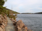
Hike Jordan Cliff Trail, Acadia National Park, Maine
The Jordon Cliff Trail along the east side of Penobscot Mountain offers spectacular views of Jordan Pond far below. The trail starts at Jordon Pond House and is rugged and potentially hazardous with exposed cliff tops. The trail is 1.6 miles to summit of Penobscot Mountain and 3.5-5 miles for a complete loop hike depending on return route. This trail is usually c... -
Explore Jordanelle Reservoir, Wasatch County, Utah
Jordanelle Reservoir is a reservoir in Wasatch County, Utah, United States, just north of Heber City. Jordanelle Reservoir is fed and drained primarily by the Provo River, and is impounded by the Jordanelle Dam, an Earthen dam. The construction of the dam resulted in the reroutings of U.S. Route 40 and U.S. Route 189 over the summit of nearby mountains and the submerg... -
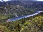
Hike around Jordan Pond, Acadia National Park, Maine
Jordan Pond is an oligotrophic tarn in Acadia National Park near the town of Bar Harbor, Maine. It covers 187 acres (76 ha), with a maximum depth of 150 feet (46 m) and a shoreline of 3.6 miles (5.8 km). The pond was formed by the Wisconsin Ice Sheet during the last glacial period. It is flanked on the west by Penobscot Mountain and to the northeast by the two mountai... -
Trek Jordan Trail, Jordon
The Jordan Trail embodies the essence of the Jordanian outdoors. It flows alongside the Great Rift Valley, overlooking rugged wadis and cliffs, and breathtaking scenery and archaeological monuments portray the layers of Jordan’s rich history, heritage, and religious relevance. After a four-year effort by Jordan’s Royal Society for the Conservation of Natur... -
Wreck Dive Joseph S. Fay Shipwreck, Thunder Bay, Michigan
The Joseph S. Fay was a wooden steamer built in 1871 Quayle and Martin at Cleveland, Ohio. At the time of launch, the Fay was the largest ship ever built in Cleveland. She hit the rocks and sank at 40 Mile Point during a strong gale on October 19, 1905. Now, its lower hull -- still containing a load of iron ore -- sits in shallow water not far from shore, wh... -
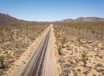
Drive Joshua Tree Highway (Nevada State Route 164), Nevada
Nevada State Route 164 (SR 164) is a state highway in southern Clark County, Nevada. The route, along with the unnumbered Nipton Road located in California, connects U.S. Route 95 (US 95) in Nevada to Interstate 15 in California just south of Primm, via the small town of Nipton, California. The highway is also known as Joshua Tree Highway. The route begins at the Cali... -
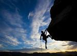
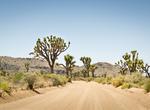
Rock Climb Joshua Tree National Park, California
Joshua Tree National Park is located in southeastern California. The park is popular with rock climbers and was originally a winter practice area while Yosemite Valley and other parts of the Sierra Nevada were snowbound, but later became an area of interest in its own right. There are thousands of named climbing routes, at all levels of difficulty. The routes are typi... -
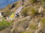
Birding at Joshua Tree National Park, California
Many animals make their homes in Joshua Tree. There are over 250 species of bird in the park including resident desert birds such as the Greater Roadrunner and Cactus Wren as well as Mockingbirds, Le Conte's Thrasher, Verdin and Gambel's Quail. There are also many transient species that may spend only one or two seasons in the park. Noted birding spots in the park inc... -
Off-road or Mountain Bike Joshua Tree National Park, California
Mountain bikes and 4-wheel-drive vehicles are welcome in the park. For your own safety and for the protection of natural features, stay on established roads. Tire tracks on the open desert can last for years and will spoil the wilderness experience of future visitors. Off-road vehicles and all-terrain vehicles may not be used in the park. The park’s unpaved...


Price: $140.24