Give us feedback!


 See all

Our philosophy is simple. We want to encourage you to dream. BIG! Then we help you plan your trip, get the most out of it while you're traveling and help you share your experience with friends.
Join Now It's FREE
Dream Packages
Duration: 4 hours
Price: $120.43
Price: $120.43
Duration: 8 hours
Price: $83.37
Price: $83.37
Duration: 7 hours
Price: $144.00
Price: $144.00
Duration: 6 days
Price: $606.00
Price: $606.00
Dreams Still To Do
Checked-Off Dreams
Dreams Still To Do
Checked-Off Dreams
Advertisement
Explore Adventure Sports
-
Ride Jurong Bird Park Panorail, Singapore
Jurong Bird Park Panorail was a 1.7-kilometre (1.1 mi) loop monorail system which ran within the Jurong Bird Park in Singapore. The monorail system used four cars, with a driver in the front car, and seats in each car, with no standing capacity. Tickets cost $5 per adult and $3 for children below 12 years old, allowing limited travel for one day. Each ticket was good ... -
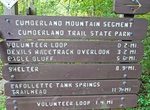
Hike Justin P. Wilson Cumberland Trail State Park, Tennessee
The Justin P. Wilson Cumberland Trail State Park is a Tennessee hiking trail following a line of ridges and gorges along the eastern escarpment of the Cumberland Plateau in Tennessee. The trail begins at Cumberland Gap National Historical Park and ends at Chickamauga and Chattanooga National Military Park and Prentice Cooper Wildlife Management Area just outside Chatt... -
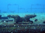
Wreck Dive K-18 ORP Bryza, Hel, Poland
K-18 ORP Bryza was a former Polish Navy ship was scuttled for a dive site in the Baltic Sea off the coast of Poland. The shipwreck ideally prepared for divers. You can visit it by diving from the boat and the shore. A buoy signaling the position of the wreck is permanently attached to it. The wreck lies on a escarpment, slightly tilted to starboard. The wreck lies at... -
Summit K2 (Savage Mountain), Pakistan & China
K2 (also known as Savage Mountain, Mountaineer's Mountain, Mount Godwin-Austen, Balti: Chogori and Sarikoli: Mount Qogir) is the second-highest mountain on Earth, after Mount Everest. With a peak elevation of 8,611 m (28,251 feet), K2 is part of the Karakoram Range, and is located on the border between Baltistan, in Gilgit-Baltistan of Pakistan-administered Kashmir an... -
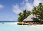
Visit Kaafu Atoll, Maldives
Kaafu Atoll is an administrative division of the Maldives. It consists of Kaashidhoo Island, Gahaafaru Atoll, and Malé Atoll (which includes the North Malé Atoll and the South Malé Atoll). It also has a number of uninhabited islands. Malé, capital of the Maldives is naturally located within the North Malé Atoll, but it is not part of... -
Hike Ka'aha Trail, Hawaii Volcanoes National Park, Big Island, Hawaii
Ka`aha is located on the southern coastline of the park, 3.8 miles from the trailhead at the end of Hilina Pali road. The hike begins with a steep downhill trail that switches back 24 times to the base of the pali (cliff). Along the trail you will be hiking through mostly non-native grasses doted with native `ohi`a trees. Two thirds of the way down you will find your ... -
Hike Ka'au Crater Trail, Honolulu, Hawaii
Ka'au Crater is a long, but rewarding up-stream hike with three large, beautiful waterfalls (one of which you will climb up) and a hidden crater. -
Hike, Snowshoe or Cross-Country Ski Kab-Ash Trail, Voyageurs National Park, Minnesota
This trail connects the Kabetogama and Ash River communities. Travel through backcountry forests and wetlands on this extensive system of interconnected trails. Four trailheads make it possible to hike sections of this trail or the whole trail for an in depth view of the park. -
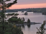
Explore Kabetogama Lake, Voyageurs National Park, Minnesota
Kabetogama Lake or Lake Kabetogama is a clear lake in northern St. Louis County, Minnesota. This body of water lies within Voyageurs National Park, and with a surface area of 25,760 acres (104 km2), it is one of the state's 10 largest inland lakes. Kabetogama Lake drains into Namakan Lake to the east, and roughly parallels the near-by Rainy Lake. The Ojibwe nameGaa-bi... -
Hike to Kabetogama Lake Overlook, Voyageurs National Park, Minnesota
This is the third pullout on your left as you are driving to the Ash River Visitor Center. This short walk is handicap accessible and will take you to a wayside that looks west towards Kabetogama Lake. -
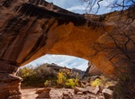
Hike to Kachina Natural Bridge, Natural Bridges National Monument
Kachina is "the middle bridge." Spanning the canyon equidistant from both Owachomo and Sipapu bridges. It is larger than Owachomo but smaller than Sipapu. Proving that canyons are dynamic rather than static, approximately 4,000 tons of sandstone fell from the inside of the Kachina bridge opening in June 1992, enlarging the opening as it has no doubt been enlarged time... -
Hike or Raft to Kachina Petroglyph Panel, Bears Ears National Monument, Utah
Kachina Petroglyph Panel is along the San Juan River in Bears Ears National Monument, Utah. There are hundreds of petroglyphs that are from 200 to thousands of years old. The panel is famous for the large broad-shouldered anthropomorph figures from the Basketmaker era. Access is from the river or Comb Wash Rd. -
Hike to Ka‘Ena Point (Ka'ena Point State Park), Oʻahu, Hawaii
Kaʻena or Kaena Point is the westernmost tip of land on the island of Oʻahu. The point can be reached on foot from both the East (via Oʻahu's North Shore / Mokulēʻia) and Southeast (via Waiʻanae Coast). An unimproved track extends some 3 miles (4.8 km) along the coast from the end of the paved road on the east side, where a gate prevents entry of all except authorized... -
Dive Kahala Barge, Oahu, Hawaii
Kahala Barge was sunk for use as an artificial reef in roughly 90 feet of water, 250 yards off the Kahala Hilton. The wreck, a 200 foot Matson Barge, lies upright and intact with a pilothouse one can penetrate, this makes for amazing photos. -
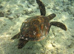
Snorkel in Kahaluʻu Bay, Big Island, Hawaii
Kahaluʻu Bay is a historic district and popular recreation area on the Kona coast of the Big Island of Hawaiʻi. The bay is still used today by surfers, with a surf school across the street from the ancient canoe landing. The area around the bay was added to the National Register of Historic Places in 1974 as historic district number 74000713 in 1974. The state re...


Price: $242.00