Give us feedback!


 See all

Our philosophy is simple. We want to encourage you to dream. BIG! Then we help you plan your trip, get the most out of it while you're traveling and help you share your experience with friends.
Join Now It's FREE
Dream Packages
Duration: 3 hours
Price: $180.00
Price: $180.00
Duration: 3 hours 30 minutes
Price: $99.36
Price: $99.36
Duration: 7 hours
Price: $144.00
Price: $144.00
Duration: 9 hours
Price: $109.14
Price: $109.14
Dreams Still To Do
Checked-Off Dreams
Dreams Still To Do
Checked-Off Dreams
Advertisement
Explore Adventure Sports
-
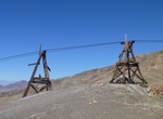
Hike to Keane Wonder Mine and Tramway, Death Valley National Park, California
Death Valley became a place of legend for people traveling westward, for its extremes and its potential as a place to strike it rich. Today as a protected landscape the modern history is still visible when you visit the park. There are over 18,000 mining features, including structures such as the aerial tramway towers and terminals at the Keane Wonder Mine. These impr... -
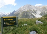
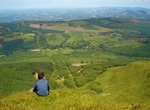
Hike Kea Point Track, Mount Cook National Park, New Zealand
Walk to a viewing deck with stunning views of the surrounding area. The track passes through a landscape that was formed in 1913 when a stream cut through from the glacier to the original Hermitage site, damaging the building. The walk ends at a viewing deck that gives stunning views of Mount Sefton, The Footstool, Hooker valley, Mueller Glacier lake and Aoraki/Moun... -
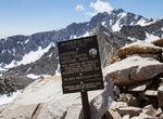
Hike Kearsarge Pass Trail, Sierra Nevada, California
Kearsarge Pass is a pass in the Sierra Nevada of California. The pass lies on the Sierra Crest at 11,709 feet (3,569 m). The pass permits foot traffic between Kings Canyon National Park and the John Muir Wilderness. The Kearsarge Pass trailhead begins at Onion Valley (9,200 feet) and travels to Kearsarge Pass (11,800 feet). The Kearsarge Pass Trail travels through the... -
Explore Keauhou Bay, Big Island, Hawaii
Keauhou Bay is a historic area in the Kona District of the Big Island of Hawaiʻi. Keauhou Bay is the birthplace of the famed King Kamehameha III and is an ideal place to snorkel, kayak, stand up paddle or even try the Hawaiian sport of Outrigger Canoeing. A small enclosure is maintained by the Daughters of Hawaii to mark the site of the birth of King Kamehameha III in... -
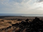
Hike to Keauhou Point, Hawaii Volcanoes National Park, Big Island, Hawaii
Keauhou is located on the southern seacoast of Hawai`i Volcanoes National Park and is one of the favored destinations of hearty wilderness hikers. The campsite is 6.8 miles from the closest trailhead. The hike to Keauhou can be a grueling, hot hike through predominately non-native grasses to a small rocky bay where cold fresh water seeps to the surface and mixes with ... -
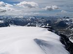
Explore Kebnekaise, Sweden
Kebnekaise (from Sami Giebmegáisi or Giebnegáisi, "Cauldron Crest") is the highest mountain in Sweden. The Kebnekaise massif, which is part of the Scandinavian Mountains, has two peaks, of which the southern, glaciated one is highest at 2,106 metres (6,909 ft) above sea level at the latest time of measurement. The north top (2,097 metres (6,880 ft)) is f... -
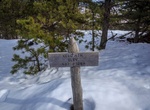
Hike Kebo Mountain Loop Trail, Acadia National Park, Maine
Kebo Mountain Loop Trail is a 2.7 mile loop trail located in Acadia National Park. The loop connects Kebo Mountain Trail with Hemlock Trail & Stratheden Path. Watch for the blue markings and cairns in some areas as the path is woodsy and rocky. -
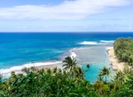
Relax on Kēʻē Beach, Kauai, Hawaii
NOTE: Non-Hawaii residents are required to purchase Park Entry Reservations ($5 per person) AND a Parking Reservation ($10 per vehicle) prior to arrival at Hāʻena SP. Entry reservations will be required for everyone in the vehicle. Parking reservations are only good for the time slots indicated during purchase. If you want to park for longer than one time slot, you ne... -
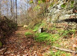
Hike or Mountain Bike Keeneys Creek Rail Trail, Nuttallburg, West Virginia
This former rail line once connected the mines and communities up Keeneys Creek to Nuttallburg and the Chesapeake & Ohio Railway mainline. Enjoy a leisurely stroll or bike ride on this wide trail that criss-crosses the rugged mountain landscape at a 4% grade. Here it is easy to see how the rugged terrain was a great challenge to those who constructed this railroad... -
Hike Keeper Hill Loop, Ireland
Keeper Hill or Slievekimalta (from Irish: Sliabh Coimeálta, meaning 'mountain of guarding') is a mountain with a height of 694 metres (2,277 ft) in the Silvermine Mountains of County Tipperary, Ireland. Traditionally, it was deemed to be part of the Slieve Felim Mountains. There is a looped walk around the lower shoulders of Keeper Hill, to which the &lsqu... -
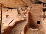
Hike to Keet Seel Cliff Dwellings (Broken Pottery), Navajo National Monument
Keet Seel is one of the best preserved ancestral pueblo villages in the Southwest. The site is located 8.5 miles from the Visitor Center. The hike is rugged, strenuous and begins at elevation 7300 feet (2225.04 m) above sea level. Allow at least 4-6 hours hiking time each way, 30 minutes to rest and have lunch, and about one hour to tour Keet Seel. The trail is marked... -
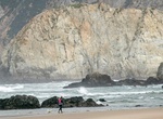
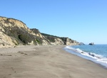
Hike to Kehoe Beach, Point Reyes National Seashore, California
A 0.6-mile (1-kilometer) walk alongside Kehoe marsh and over a sand dune takes you to Kehoe Beach, which is located at the northern end of Point Reyes Beach. Once at the beach, turn left to explore a stream meandering its way into the Pacific Ocean. To the right, the drama of Point Reyes geology is on display. The rocks here are millions of years old! The first cliffs... -
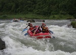
Whitewater Raft Kelani River (Kitulgala), Sri Lanka
Kitulgala is a small town in the west of Sri Lanka. It is in the wet zone rain forest, which gets two monsoons each year, and is one of the wettest places in the country. Nevertheless, it comes alive in the first three months of the year, especially in February, the driest month. The Academy Award-winningThe Bridge on the River Kwaiwas filmed on the Kelani River near ... -
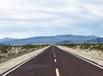
Drive Kelbaker Road, Mojave National Preserve, California
Kelso and Baker are connected by Kelbaker Road, a 56-mile paved road stretching from I-15 at Baker in the north to I-40 east of Ludlow, in the south. About 16 miles southeast of Baker, Kelbaker Road traverses a 25,600-acre area of lava flows and volcanic cinder cones thought to range in age form 10,000 to 7 million years old. In 1973, the area was designated as Cinder... -
Hike to Kelham Beach Overlook, Point Reyes National Seashore, California
NOTE: Kelham Beach was one of the more remote beaches at Point Reyes, but is no longer safe to visit. As of 2024, there are no safe routes to access Kelham Beach. In January 2023, coastal erosion eliminated the lowest 12 feet or so of steps at the bottom of the Kelham Beach Trail. In April 2024, a much larger landslide occurred, taking out even more of the Kelham Beac...

Price: $106.33