Give us feedback!


 See all

Our philosophy is simple. We want to encourage you to dream. BIG! Then we help you plan your trip, get the most out of it while you're traveling and help you share your experience with friends.
Join Now It's FREE
Dream Packages
Duration: 2 days
Price: $469.00
Price: $469.00
Duration: 3 hours
Price: $180.00
Price: $180.00
Duration: 15 hours
Price: $149.00
Price: $149.00
Duration: 6 days
Price: $606.00
Price: $606.00
Dreams Still To Do
Checked-Off Dreams
Dreams Still To Do
Checked-Off Dreams
Advertisement
Explore Adventure Sports
-
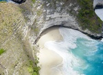
Relax at Kelingking Beach, Bali, Indonesia
Kelingking Beach is placed under the cliff which you’ll have to climb down if you want to touch the sand. Not for faint-hearted but totally worth the effort! Rememebr that you’ll have to hike up too though... -
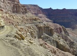
Off-road Kelly Grade, Utah
Kelly Grade is the portion of Smoky Mountain Road that abruptly changes elevation by almost one thousand feet from the Kaiparowits Plateau to the flats north of Lake Powell. -
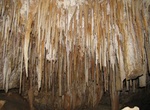
Explore Kelly Hill Caves, Kangaroo Island, South Australia
Kelly Hill Caves system is the main attraction within the Kelly Hill Conservation Park which is located on Kangaroo Island, South Australia. -
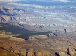
Off-Road to Kelly Point Overlook, Arizona
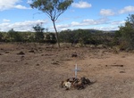
Kelly Point Overlook is a viewpoint overlooking the Colorado River. The road is through Grand Canyon - Parashant National Monument. The overlook is on NPS land administered by Grand Canyon National Park or Lake Mead National Recreation Area. The road to Kelly Point is long and rough. It is usually a two-day round trip from St. George (115 miles one-way). For Kelly P... -
Off-road Kelly Point Road (BLM 1203), Grand Canyon-Parashant National Monument, Arizona
The Kelly Point road (NPS1203) leads to fantastic views but is only for those with the fortitude to withstand hours of bouncing around the cab of a very high clearance 4x4 or a UTV. NPS1203 starts by Mt. Dellenbaugh where Mohave County Road 103 ends at the BLM/NPS boundary. There are numerous flat sandy places to camp at the end of the road near the canyon rim, all wi... -
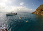
Visit Kelly's Cove & Water Point, Norman Island, BVI
Kelly's Cove is locacted next to Water Point on Normand Island in the BVI's. The cove has 6 mooring buoys (pay at Willy's) and anchorages. -
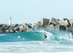
Surf Kelly Slater Surf Ranch, Lemoore, California
The Kelly Slater Wave Company combines cutting edge science, engineering and design to create the longest, rideable open-barrel man made wave in the world. categories -
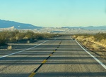
Drive Kelso Cima Road, Mojave Desert, California
Kelso-Cima Road is a 19 mile paved road and a main highway through the central part of Mojave National Preserve, connecting the "towns" of Kelso and Cima. -
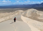
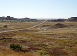
Hike or Sandboard Kelso Dunes, Mojave National Preserve, California
Kelso Dunes, also known as the Kelso Dune Field, is the largest field of eolian sand deposits in the Mojave Desert. Hikers at sunrise and sunset are treated to both cooler temperatures and the rose-colored glow of the dunes. The roughly 3-mile round-trip hike might take several hours as you slog through the sand, then slide down the slopes. Moving sands sometimes crea... -
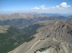
Hike Kelso Ridge, Arapaho National Forest, Colorado
Kelso Ridge connects two 14,000-foot peaks (Grays and Torreys) within Arapaho National Forest, Colorado. The 7.5-mile loop trail starts from the Grays And Torreys Trailhead. -
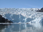
Sea Kayak Kenai Fjords National Park, Alaska
Sea Kayaking Kenai Fjords National Park in Alaska while watching massive tidewater glaciers calve into the ocean. Traveling with a guide is strongly recommended for inexperienced paddlers. The fjords are exposed to the Gulf of Alaska, with only a few protected coves. These are not waters for beginners! Landings often involve surf, particularly when afternoon breezes ... -
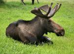
Explore Kenai National Wildlife Refuge, Alaska
The Kenai National Wildlife Refuge is a 1.92 million acre wildlife preserve located on the Kenai Peninsula of Alaska. The refuge was created in 1941 as the Kenai Moose Range, but in 1980 it was changed to its present status by the Alaska National Interest Lands Conservation Act. There is a wide variety of terrain in the refuge, including muskeg and other wetlands, alp... -
Drive Kennedy Developmental Road between Hughenden to Porcupine Gorge, Queensland, Australia
Porcupine Gorge National Park extends for more than 25 kilometres along Porcupine Creek. The gorge lookout is around 60 kilometres north of Hughenden. The Pyramid campground and gorge walk are another 11 kilometres further north. Zero your tripmeter at the Flinders Discovery Centre and travel north along the Kennedy Development Road (Hann Highway). As you drive along... -
Drive Kennedy Developmental Road between Winton and Boulia, Queensland, Australia
Kennedy Developmental Road (State Highway 62) goes between Winton and Boulia. -
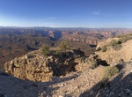
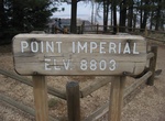
Hike Ken Patrick Trail, Grand Canyon National Park, Arizona
Ken Patrick Trail in Grand Canyon National Park is a 10 miles (16 km) one-way trail that winds through the forest and along the rim from Point Imperial to the North Kaibab Trail parking area. Highest point is a 8,819 ft (2,688 m). It takes approximately 6 hours one-way. Access to this part of the park by car is seasonal, traditionally open from mid-May to mid-Oct...
Price: $173.83