Give us feedback!


 See all

Our philosophy is simple. We want to encourage you to dream. BIG! Then we help you plan your trip, get the most out of it while you're traveling and help you share your experience with friends.
Join Now It's FREE
Dream Packages
Duration: 2 days
Price: $469.00
Price: $469.00
Duration: 4 hours
Price: $120.43
Price: $120.43
Duration: 2 days
Price: $242.00
Price: $242.00
Duration: 6 days
Price: $606.00
Price: $606.00
Dreams Still To Do
Checked-Off Dreams
Dreams Still To Do
Checked-Off Dreams
Advertisement
Explore Adventure Sports
-
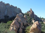
Hike or Mountain Bike Backbone Trail, Santa Monica Mountains, California
The Backbone Trail is a long distance trail extending 67.79 miles (109.10 km) across the length of the Santa Monica Mountains in the U.S. state of California. Its western terminus is Point Mugu State Park and its eastern terminus is Will Rogers State Historic Park in Pacific Palisades. The trail is open to hikers throughout its length; dogs, mountain bicyclists and ho... -
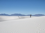
Hike Backcountry Camping Trail, White Sands National Monument, New Mexico
Are you looking for expansive views of snow-white gypsum dunes for miles? If so, this trail is for you. Hiking the Backcountry Camping Trail provides a sense of the magnitude of the world's largest gypsum dunefield while not having to venture too far from one's vehicle. The Backcountry Camping Trail is a moderate, 2-mile (3.5 km), round-trip hike. Though backpackers ... -
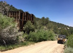
Off-road Backway 4x4 Road to Bodie Ghost Town, California
Most tourists reach Bodie Ghost Town (Bodie State Historic Park) via paved Hwy. 270. The trip described here is a more interesting backcountry route starting north of Bridgeport. On the way you’ll see great views, structures at the Chemung Mine and the historic site of Masonic. Located in Humboldt-Toiyabe National Forest. Rating: Easy. Any high clearance SUV ca... -
Visit Bac My An Beach, Danang, Viet Nam
Bac My An contains 5 beaches with the resort. Its 4km coastline has white sand and blue water. You can enjoy different spots and choose what you like best. -
Hike Baden-Powell Trail, BC, Canada
The Baden-Powell Trail is a rugged but well-maintained trail that traverses Greater Vancouver's North Shore region. The trail is about forty-eight kilometres long, extending (west to east) from Horseshoe Bay in West Vancouver to Deep Cove in the District of North Vancouver. In between, the trail winds through the heavily forested North Shore Mountains. It also connect... -
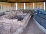
Hike Badger House Community Trail, Mesa Verde National Park, Colorado
Take the gravel trail south from the Wetherill Mesa Kiosk, pass the junction to Nordenskiöld Site #16 Trail and cross the paved Long House Loop to explore the 1-mile (1.6 km) loop through the Badger House Community—four excavated mesa top villages representing 600 years of Pueblo history. -
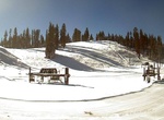
Ski/Snowboard Badger Pass Ski Area, Yosemite National Park, Mariposa, California
Badger Pass Ski Area is a small ski area located within Yosemite National Park. Badger Pass is one of only three lift serviced ski areas operating in a US National Park (Hurricane Ridge Ski and Snowboard Area in Olympic National Park and Boston Mills/Brandywine Ski Resort in the Cuyahoga Valley National Park are the others). It is situated five miles (8 km) south-sout... -
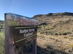
Explore Badger Springs Trail, Agua Fria National Monument, Arizona
Badger Springs offers a short trail for non-motorized users within the Agua Fria National Monument. The trail leads down the Badger Springs Wash to the Agua Fria River canyon, an area rich in archaeological resources. The wash may be wet or muddy. Informational panels and a toilet are available near the trailhead. Toilets are accessible. The confluence of Badger Spr... -
Drive or Cycle Badlands Loop Road (Hwy 240), Badlands National Park, South Dakota
The Highway 240 Badlands Loop Road, accessed from Interstate 90, is a two-lane, paved surface that takes you through the North Unit of the park. The Badlands Loop Road is open to cyclists who prefer a paved riding experience. While bicycles are allowed on the road, it is not without its hazards. The scenic road is narrow with many curves. Traffic is heavy from Memori... -
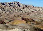
Hike Badlands Loop Trail, Death Valley National Park, California
The Badlands Loop Trailhead is located at Zabriskie Point. It's a 2.7 mile (4.3km) loop that should take 1.5 - 2 hours round trip. The loops winds through colorful badlands composed of an ancient lakebed. Pay close attention as you weave through this maze of narrow drainages looking for small signs at each major intersection. Zabriskie Point on CA-190 located 3.5 mil... -
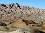
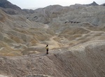
Explore Badlands National Park, South Dakota
Badlands National Park, in southwest South Dakota, United States preserves 244,000 acres (98,740 ha) of sharply eroded buttes, pinnacles, and spires blended with the largest protected mixed grass prairie in the United States. Bison, bighorn sheep, prairie dogs, and black-footed ferrets can be seen at the park. These striking geologic deposits contain one of the world&... -
Drive Badwater Road, Death Valley National Park, California
Badwater Road is a 70 mile, paved road in Death Valley National Park which becomes State Hwy 178 the last few miles south to Hwy 127. Provides access to Golden Canyon, West Side Road, Artist’s Drive, Devil’s Golf Course, Natural Bridge, and Badwater. Road is narrower and rougher south of Badwater. Subject to flooding and closure after heavy rains. -
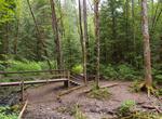
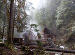
Hike to Bagby Hot Springs, Oregon
The Bagby Hot Springs are natural hot springs located in the Mount Hood National Forest about 67 miles (108 km) southeast of Portland, Oregon, United States and about 41 miles (66 km) east of Salem, Oregon. The springs are within the Cascade Mountains in a heavily forested area at elevation 2280 ft (695 m). The springs are just outside the boundary of Bull of the Wood... -
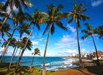
Visit Bahia, Brazil
The northeastern state of Bahia is probably best known for its capital city of Salvador. The city with its top resorts, beautiful coastline, and unique mix of African and European style is quickly becoming quite the competition to Brazil’s other hot spot – Rio de Janeiro. In addition to pristine beaches, Salvador has plenty of natural swimming pools and a ... -
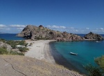
Visit Bahia Agua Verde, Baja California Sur, Mexico
Bahia Agua Verde is a nice bay on the Sea of Cortez in Baja California Sur, Mexico. Access via boat or a decent dirt road from Hwy 1 to the north. There is a Agua Verde backdoor road from the south that is passable with 4x4 or dirt bike. Especially downhill (south to north). Uphill is very steep and in bad shape. The road does get washed out.


Price: $140.24