Give us feedback!


 See all

Our philosophy is simple. We want to encourage you to dream. BIG! Then we help you plan your trip, get the most out of it while you're traveling and help you share your experience with friends.
Join Now It's FREE
Dream Packages
Duration: 3 hours
Price: $173.83
Price: $173.83
Duration: 2 days
Price: $242.00
Price: $242.00
Duration: 7 hours
Price: $179.00
Price: $179.00
Duration: 4 hours
Price: $120.43
Price: $120.43
Dreams Still To Do
Checked-Off Dreams
Dreams Still To Do
Checked-Off Dreams
Advertisement
Explore Adventure Sports
-
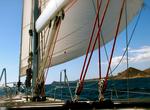
Sail or Cruise Baja California Coast, Mexico
Sailing or cruising down the Pacific side of Baja California can be a wonderful experience. The rugged coastline and only a handful of anchorages hide some of the most isolated parts of the peninsula. The season starts when the hurricane season ends (and the humity goes away), usually about the second week of October. There are two organized events for groups to sail ... -
Hike Baja Coast to Coast, Baja California, Mexico
Baja Coast to Coast crosses the narrowest part of the Baja California peninsula. It'sa must experience for sports travelers, hikers, trekking and lovers of contact with nature. This event is not a race. It's organized by Adixion Tour. The annual event is usally held in mid November. This event consists of a walk of 110 km over 3 days, starting from Playa Altamira on... -
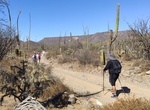
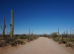
Drive or Cycle Bajada Loop Drive, Saguaro National Park, Arizona
The Bajada Loop Drive in the Tucson Mountain District (west) is a 6-mile gravel loop that includes Hohokam Road and Golden Gate Roads. Drive the loop counter clockwise since one section is one-way. Golden Gate and Hohokam Roads are dirt roads and close at sunset. Travel on Hohokam Road is not recommended for long vehicles. -
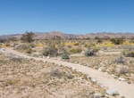
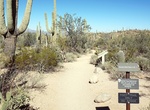
Hike Bajada Nature Trail, Joshua Tree National Park
Bajada Nature Trail is located on the southeast side ofJoshua Tree National Parkbetween the 10 Freeway and the Cottonwood Visitor Center. This short nature trails introduce visitors to the ecological variety of the Southern California desert. Sixteen panels along Bajada Trail describe the Colorado Desert plants that manage to survive on this bajada. -
Hike Bajada Wash Trail, Saguaro National Park, Arizona
Bajada Wash Trail in the Tucson Mountain District (west) is a 3.1 mile rough trail that starts at Sus Picnic Area and parrallels Hohokam Road. There is a restroom at Sus Picnic Area. Stock is prohibited from Bajada Wash Trail from Valley View Overlook Trail to Sus Picnic Area. -
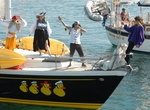
Go on Baja Ha Ha Rally, Baja, Mexico
Sailing down the Pacific side of Baja California can be a wonderful experience. The rugged coastline and only a handful of anchorages hide some of the most isolated parts of the peninsula. The season starts when the hurricane season ends (and the humity goes away), usually about the second week of October. The Baja Ha Ha is one of two organized events for groups to go... -
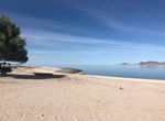
Camp at Baja Playa Del Sol, Baja California, Mexico
Baja Playa del Sol is located just north of San Luis Gonzaga Bay and is only 90 miles south of San Felipe. -
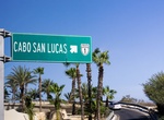
Drive Baja's Trans-peninsular Highway (Federal Highway 1), Baja California, Mexico
Federal Highway 1, known to many as 'Baja's Trans-peninsular Highway', is a toll-free (libre) part of the federal highway corridors of Mexico, and the highway follows the length of the Baja California Peninsula from Tijuana in the north to Cabo San Lucas in the south. The road connects with Via Rapida, which merges into the American Interstate 5 (I-5) at the San Ysidr... -
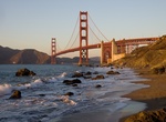
Visit Baker Beach, San Francisco, California
Baker Beach is a public beach on the peninsula of San Francisco, California, U.S.. The beach lies on the shore of the Pacific Ocean to the northwest of the city. It is roughly a half mile (800 m) long, beginning just south of Golden Gate Point (where the Golden Gate Bridge connects with the peninsula), extending southward toward the Seacliff peninsula, the Palace of t... -
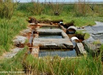
Soak Baker Hot Springs, Delta, Utah
Baker Hot Springs (also known as Crater Springs and Abraham Hot Springs are a series of geothermal spring located on Fumarole Butte, northwest of the town of Delta, Utah. The hot mineral water emerges from the spring at 180°F/82°C. The primary mineral content is manganese, and water has a high sulphur content giving it the characteristic "rotten egg" smell. Th... -
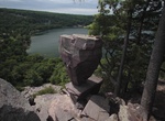
Hike to Balanced Rock (Devil's Lake State Park), Wisconsin
Hike the Ice Age Trail in Devil's Lake State Park to reach Balanced Rock. It's 0.4 miles (0.64 km) one-way. Over 100 years ago, the south shore of Devil’s Lake (just below you) looked much different than it does today.European immigrants and settlers took note of the lake in the mid-1800s, and with the routing of a rail line through the lake valley, tourism bega... -
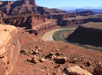
Hike to Balanced Rock & Gooseneck Overlook (Canyonlands), Utah
The short Gooseneck Trail leads to an overlook point 1,900 feet above the Colorado River. It's located off the White Rim Road in Canyonlands National Park, Utah. The Colorado turns abruptly north below the overlook and then bends around to the south again, making a 180-degree arc that is four miles long. Dead Horse Point State Park is situated just one mile north of t... -
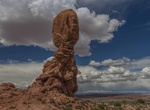
Hike Balanced Rock Trail, Arches National Park, Utah
Balanced Rock is one of the most popular features of Arches National Park. A loop trail at the base of a fragile, picturesque rock formation. Part of the trail is paved and accessible to wheelchairs. The total height of Balanced Rock is about 128 feet (39 m), with the balancing rock rising 55 feet (16.75 m) above the base. The big rock on top is the size of three... -
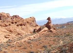
Hike Balanced Rock Trail (Valley of Fire), Nevada
Watch out now! This formation of red sandstone could topple over at any minute. Not really. But it sure looks like it will! Walk this quarter-mile roundtrip trail to see this precarious rock formation. And while you’re at it, check out the nearby visitor center to learn about the park’s geology, animals, and past human inhabitants. Distance: 0.25 roundtri... -
Swim at Balata dei Turchi, Pantelleria, Italy
Balata dei Turchi is a nice place to swim on the island of Pantelleria.

Price: $109.14