Give us feedback!


 See all

Our philosophy is simple. We want to encourage you to dream. BIG! Then we help you plan your trip, get the most out of it while you're traveling and help you share your experience with friends.
Join Now It's FREE
Dream Packages
Duration: 7 hours
Price: $144.00
Price: $144.00
Duration: 8 hours
Price: $83.37
Price: $83.37
Duration: 4 hours 30 minutes
Price: $176.03
Price: $176.03
Duration: 3 hours
Price: $140.24
Price: $140.24
Dreams Still To Do
Checked-Off Dreams
Dreams Still To Do
Checked-Off Dreams
Advertisement
Explore Adventure Sports
-
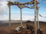
Hike Mauna Kea-Humu'ula Trail, Big Island, Hawaii
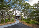
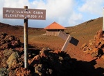
The Mauna Kea Trail is considered the easiest route to hike to the summit of Mauna Kea volcano, the highest volcano on the island of Hawaʻi. The trail is 6 mi (10 km) long and loosely follows an unmaintained dirt road. Iron poles mark the path every 500 ft (152 m). The trail starts at the Visitor Information Station at the Onizuka Center for International Astronomy at... -
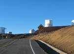
Drive Mauna Kea Summit Road, Big Island, Hawaii
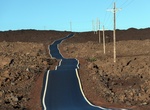
Mauna Kea Summit Road (known as John A. Burns Way) provides access to the Onizuka Center for International Astronomy (at elevation 9,300 ft / 2,835m) then climbs Mauna Kea past the Mauna Kea Ice Age Reserveto the height of 13,780 ft (4,200m) at grades averaging 17% making this the third highest public road in the United States. The road is 14 miles (23 km) long, of wh... -
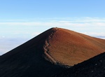
Hike Mauna Kea Summit Trail, Big Island, Hawaii
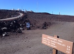
Note: There is a sign on Mauna Kea asking people not to hike to the summit due to cultural sensitivity and significance Mauna Kea Summit Trail is a loop trail from the Sunset Parking lot on Mauna Kea around the rim of Mauna Kea. Of hike 6 miles on the Humu'ula Trail from Visitor Information Station. The entire upper portion of the Humu'ula Trail is leased by the Univ... -
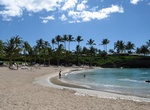
Explore Mauna Lani and Makaiwa Bay Beaches, Big Island, Hawaii
Both Mauna Lani Beach and Makaiwa Bay are located near the Mauna Lani Resort on the Big Island of Hawaii. These are excellent places to snorkel, kayak, stand up paddle at both beaches but they require a fairly long walk to get to each. To access the shared parking lot of both of these places you must enter the Mauna Lani Resort. When you reach the resorts gate gu... -
Drive Mauna Loa Observatory Road, Big Island, Hawaii
Mauna Loa Observatory Road is an unmarked 17.1 mile (27.5km) long narrow rough (but paved) road which winds its way towards Mauna Loa Solar Observatory, Mauna Loa Atmospheric Observatory, and AMiBA on the slopes of Mauna Loa. It was connected in 1963 to the old Tom Vance road from 1950. -
Drive Mauna Loa Road to Mauna Loa Lookout, Hawaii Volcanoes National Park, Hawaii
Drive the narrow, winding and potholed Mauna Loa Road to Mauna Loa Lookout (6662ft). Here there is a protected cluster of endangered ʻahinahina (Mauna Loa silversword) plants, and the start of the challenging and rewarding Mauna Loa Trail. -
Hike Mauna Loa Summit Trail, Hawaii
Mauna Loa Summit via Observatory Trail is a 28.0 kilometer moderately trafficked out and back trail located near Volcano, Hawaii, Hawaii that features beautiful wild flowers and is rated as difficult. The trail is primarily used for hiking, walking, camping, and nature trips and is accessible year-round. -
Hike Mauna Loa Trail, Hawaii Volcanoes National Park, Hawaii
The Mauna Loa Trailhead is at the end of Mauna Loa Road at at 6700', near the Mauna Loa lookout and picnic area. A lot of people make this into a 4-day excursion, utilizing the hut system for overnights. -
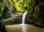
Hike Maunawili Falls Trail, Oahu, Hawaii
Maunawili Falls is tucked away deep in the Maunawili Valley below the towering Pali Cliffs. A fun Oahu hiking trail will lead you up and back down the hillside to this local Oahu waterfall. The adventurous 2 mile Maunawili Falls Trail is marked and maintained by the city & county. -
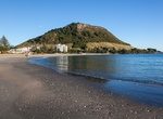
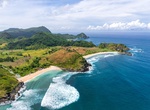
Visit Maunganui Beach, New Zealand
Maunganui Beach is at the base of Mount Maunganui (Mauao), an extinct volcano. Make sure to enjoy this beautiful long white sandy beach. The beach has everything from surf lifesaving events to beach volleyball, parasailing, sandcastle building and surfing contests. The beach has plenty of facilities including, surf board rental, restaurants and Cafes. -
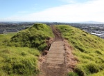
Summit Maungarei (Mount Wellington), Auckland, New Zealand
Maungarei / Mount Wellington is a 135-metre volcanic peak located in the Auckland volcanic field of Auckland, New Zealand. It is the youngest onshore volcano of the Auckland volcanic field, having been formed by an eruption around 10,000 years ago. It is the largest of Auckland's scoria cones and has a near-circular base with a flattish rim and three small fire-founta... -
Visit Mauritius Island, Mauritius
Mauritius Island is the main island of the Mauritius nation. The island is off the southeast coast of the African continent in the southwest Indian Ocean, about 900 kilometres (560 mi) east of Madagascar. Together with Réunion and Rodrigues, Mauritius is part of the Mascarene Islands. This archipelago was formed in a series of undersea volcanic eruptions 8-10 m... -
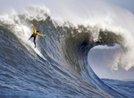
Surf Mavericks, Northern California
Mavericks is a surfing location in Northern California, USA. It is located approximately 2 miles (3.2 km) from shore outside Pillar Point Harbor, just north of the town of Half Moon Bay at the village of Princeton-by-the-Sea. After a strong winter storm in the northern Pacific Ocean, waves can routinely crest at over 25 feet (7.6 m) and top out at over 80 feet (2... -
Relax at Mawi Beach, Lombok, Indonesia
Mawi Beach is located in the south of Lombok Island. It's one of the nicest beaches but also one of the hardest to get to. It requires driving through a very bumpy road which is long and tiresome. -
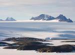
Visit Mawson Station, Antarctica
Mawson Station is one of three permanent Australian bases in the Australian Antarctic Territory of East Antarctica. Named after Antarctic explorer Sir Douglas Mawson, the base is managed by the Australian Antarctic Division (AAD). Established in 1954, Mawson is Australia's oldest Antarctic station and the oldest continuously inhabited Antarctic station south of the An...
Price: $606.00