Give us feedback!


 See all

Our philosophy is simple. We want to encourage you to dream. BIG! Then we help you plan your trip, get the most out of it while you're traveling and help you share your experience with friends.
Join Now It's FREE
Dream Packages
Duration: 3 hours
Price: $173.83
Price: $173.83
Duration: 9 hours
Price: $109.14
Price: $109.14
Duration: 4 hours
Price: $120.43
Price: $120.43
Duration: 2 days
Price: $242.00
Price: $242.00
Dreams Still To Do
Checked-Off Dreams
Dreams Still To Do
Checked-Off Dreams
Advertisement
Explore Adventure Sports
-
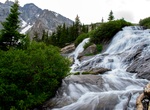
Hike McCullough Gulch Waterfall Trail, Breckenridge, Colorado
The McCullough Gulch Waterfall Trail near Breckenridge is a moderiate 3.6-mile out-and-back trail. From the trailhead you will be hiking on an old mining road through the McCullough Gulch drainage. Eventually you turn onto a trail that leads you to a viewpoint of White Falls. You can continue up the trail to a beautiful alpine lake with a magnificent view of the entir... -
Hike McDermid Rock Loop, Norseman, Western Australia
McDermid Rock Loop is an easy hike that starts at MCDermid Rock Campground. -
Hike to McDougall Falls, Canada
McDougall Falls is a waterfall on the Murtle River in Wells Gray Provincial Park, east-central British Columbia, Canada. McDougall Falls is located 5 km downstream from the Diamond Lagoon of Murtle Lake. It is 14 m high. A hiking trail follows the south shore of the Murtle River from the lagoon. This trail is only accessible by canoeing across Murtle Lake. The waterfa... -
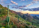
Explore McDowell Sonoran Preserve, Scottsdale, Arizona
Scottsdale’s McDowell Sonoran Preserve is a permanently protected 30,000-acre sustainable Sonoran Desert habitat open for non-motorized trail use. The Preserve provides critical refuge for native plants and animals living near urban environments. The Preserve connects in the north with the three-million-acre Tonto National Forest and in the southeast with the 21... -
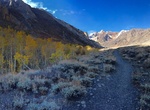
Hike McGee Creek Trail, Mammoth Lakes, California
The McGee Creek Trailhead is located at the end of McGee Creek Road. The trail follows the aspen-lined creek up to a number of alpine lakes and offers big mountain views. Steelhead Lake is a popular destination though the trail continues on to Big McGee Lake and eventually reaches the Sierra Nevada Crest at McGee Pass. McGee Creek is a favorite for spring wildflowers... -
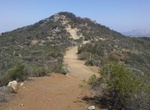
Mountain Bike McGinty Mountain Trail, Jamacha, California
McGinty Mountain to the Old Abandoned House is about 11.6 miles long and located near Jamacha, California. The trail is great for mountain biking and normally takes 1-3 hours. There is a small paring lot at the trailhead. If full then consider parking at the Steele Canyon Golf Course. The initial ascent up the mountain can only be fully ridden by the most advanced r... -
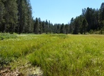
Hike McGurk Meadow Trail (Bridalveil Creek, and Dewey Point), Yosemite National Park, California
The trail leads downhill 0.8 miles (1.3 km) to McGurk Meadow and the site of an old cabin that belonged to John McGurk. One mile (1.6 km) beyond the cabin are trails west to Dewey Point and east to Bridalveil Creek. During July, the meadows in this area are a great place to see wildflowers. Bridalveil Creek: 4 mi/6.4 km round-trip; 2-3 hours Dewey Point: 8.2 mi/12... -
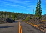
Drive McKenzie Highway (Hwy 242), Oregon
The McKenzie Highway is also known as Oregon Route 242 (OR 242) and Forest Highway (FH) 22. The highway travels through Lane, Linn, and Deschutes counties; beginning at the junction with OR 126 near the town of McKenzie Bridge and ending at the junction with US Highway 20 and OR 126 at the City of Sisters. The McKenzie Highway is part of the McKenzie Pass - Santiam P... -
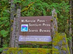
Drive McKenzie Pass–Santiam Pass Scenic Byway, Oregon
The McKenzie Pass–Santiam Pass Scenic Byway is an 82-mile-long (132 km) National Scenic Byway in the U.S. state of Oregon. The route is a loop designed to provide a tour of the high Cascade Range northwest of Bend, passing over both McKenzie Pass and Santiam Pass. The route begins on its eastern end at the town of Sisters in northern Deschutes County. It follows... -
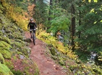
Hike or Mountain Bike McKenzie River Trail, Oregon
McKenzie River Trail in Oregon is a 26 miles single-track hiking & biking trail with waterfalls, log bridges and river views. The trail starts in an old lava flow at the Upper McKenzie River Trailhead. -
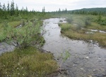
Hike McKinley Bar Trail, Alaska
McKinley Bar Trail is a 4.6 mile moderately trafficked out and back trail located near Denali National Park, Alaska that features a lake and is good for all skill levels. The trail is primarily used for hiking, walking, nature trips, and bird watching and is best used from May until October. -
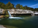
Explore McKinney Falls State Park, Austin, Texas
McKinney Falls State Park is a state park in Austin, Texas, United States at the confluence of Onion Creek and Williamson Creek. It is administered by the Texas Parks and Wildlife Department. The park opened on April 15, 1976 and is named after Thomas F. McKinney, a businessman, race horse breeder and rancher, who owned and lived on the land in the mid-to-late 19th ce... -
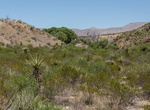
Hike to McKinney Spring, Big Bend National Park, Texas
It's a short hike to McKinney Spring from the primitive campsite. Vegetation includes creosote, lechuguilla, grasses, and shrubby mesquite. There is a small grove of cottonwood trees 0.25 miles up the nearby drainage. The wash downstream of the site provides access to the upper Tornillo Creek area. -
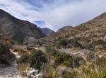
Hike McKittrick Canyon Trail, Guadalupe Mountains National Park, Texas
Tucked within 2,000-foot-high limestone walls is a place that some call the "most beautiful spot in Texas." The serpentine route of McKittrick Creek creates conditions for an unusual community of plants and a menagerie of animals. Rich with history, rich in diversity, glorified by its beauty, and famous for is outstanding fall colors, this location of the park is a "m... -
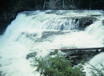
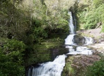
Hike to McLean Falls, Catlins Forest Park, New Zealand
The McLean Falls on the Tautuku River in Catlins Forest Park descend a number of steep drop offs and terraces, with the very top of the waterfall, where it meets its first waterpool being 22-metres. It then descends for many more metres over a series of terraces. The McLean Falls are often described as the most spectacular in the region, with its sister waterfall...
Price: $208.72