Give us feedback!


 See all

Our philosophy is simple. We want to encourage you to dream. BIG! Then we help you plan your trip, get the most out of it while you're traveling and help you share your experience with friends.
Join Now It's FREE
Dream Packages
Duration: 3 hours
Price: $140.24
Price: $140.24
Duration: 7 hours
Price: $179.00
Price: $179.00
Duration: 8 hours
Price: $208.72
Price: $208.72
Duration: 3 hours
Price: $173.83
Price: $173.83
Dreams Still To Do
Checked-Off Dreams
Dreams Still To Do
Checked-Off Dreams
Advertisement
Explore Adventure Sports
-
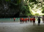
Visit Morakot Cave (Emerald Cave), Thailand
Emerald Cave (Tham Morakot) is a cave located on the west coast of Muk Island, which is in the Kantang District of Trang Province of Southern Thailand. The cave has a narrow 80m long tunnel. The cave can be entered either by swimming or by using a small boat. Access is only possible during low tide. Outside the cave, there is a lagoon which is surrounded by tropical p... -
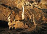
Explore Moravian Karst & Caves, Czechia
The Moravian Karst is a karst landscape and protected nature reserve to the north of Brno in the eastern part of the Czech Republic, located near the town of Blansko. It encompasses a number of notable geological features, including roughly 1100 caverns and gorges and covers an area of roughly 92 km². Currently, four of the cave systems (Punkva Caves, Balcarka Ca... -
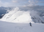
Ski or Snowboard Morillon, France
Morillon is a commune in the Haute-Savoie department in the Rhône-Alpes region in south-eastern France. Morillon has a Poma télécabine that departs from just outside the village and links up to the Grand Massif ski area consisting of 265 km of ski runs over the five resorts of Morillon, Samoëns, Flaine, Les Carroz, and Sixt. Morillon is also t... -
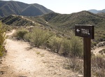
Hike Morley Field Trails, Balboa Park, San Diego, California
On the northeast side of the park is a gateway into three trails: The 2.3-mile trail follows a popular course used in high school cross-country competitions. Type: ½ grass, ½ dirt trail with some rocky areas. Difficulty level: Easy. Follow the #11 round red trail markers. View Google map. The 2.4-mile trail goes through not-often-seen natural areas of ... -
Hike Mormon Rocks Interpretive Trail, Cajon Junction, California
Beginning elevation is 3360 feet. This 1-mile loop trail was built by the Forest Service fire engine crew in 1975. It provides visitors with the chance to hike to a ridge to gain great views of the Mormon Rocks. These striking sandstone formations are riddled with small holes and caves; home of the owl, lizard, and pack rat. In the cliffs watch for White-throated Swi... -
Hike along the Mormon Trail
The Mormon Trail or Mormon Pioneer Trail is the 1,300 mile (2,092 km) route that members of The Church of Jesus Christ of Latter-day Saints traveled from 1846 to 1868. Today the Mormon Trail is a part of the United States National Trails System, as the Mormon Pioneer National Historic Trail. The Mormon Trail extends from Nauvoo, Illinois, which was the principal settl... -
Off-road Mormon Trail through East Fork of Lake Canyon (Hole in the Rock Eastside), Utah
Off-road the Mormon Trail (Emigrant Trail) through the East Fork of Lake Canyon, Utah. This is consider the eastern side of the Hole in the Rock Road. From route 276, turn south on Nokai Dome Road and turn right about 5 mles down this dirt road. After around another 3 miles the road turns left and then forks - stay on the same road. The fun part of the trail starts i... -
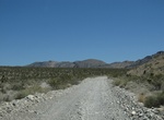
Off-road Mormon Well Road, Nevada
The 41.6 mile Mormon Well Road crosses the Desert National Wildlife Refuge. This well-maintained dirt road that rises in elevation from the desert floor to more than 6,000 feet in elevation. High clearance for some of the rougher places. Did not require 4 wheel drive. Passenger cars commonly seen on the trail. Check here for current road conditions. Mormon Well Spr... -
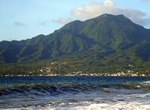
Summit Morne Diablotins, Dominica
Morne Diablotins is the highest mountain in Dominica, an island-nation in the Caribbean Lesser Antilles. It is the second highest mountain in the Lesser Antilles, after La Grande Soufrière in Guadeloupe. Morne Diablotins is located in the northern interior of the island, about 15 miles north of Dominica's capital Roseau and about 6 miles southeast of Portsmouth... -
Hike to Morong Falls, Kanangra-Boyd National Park, New South Wales, Australia
Morong Falls are a big set of falls located in Kanangra-Boyd National Park, New South Wales, Australia. -
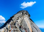
Summit Moro Rock, Sequoia National Park, California
To reach the top of this granite dome, follow a stairway that climbs 300 feet (0.09 km) to the summit. A spectacular view of the Great Western Divide and the western half of the park. The parking area is two miles (3.2 km) from the Generals Highway. In summer, free park shuttles lead to the parking area from Giant Forest Museum. Don't climb if ice or snow are present ... -
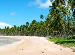
Visit Morro de São Paulo, Tinharé Island, Brazil
Morro de São Paulo is one of 5 villages of the island Tinharé in Bahia, Brazil, 272 km from the city of Salvador by route and 60 km by sea. As part of the municipality of Cairu (only archipelago municipality in Brazil), the way to go to the island is by boat or by regular flights that go from the airport of Salvador to the local airstrip. Cars are forbid... -
Summit Morro Dois Irmãos (Two Brothers), Rio de Janeiro, Brazil
TheDois Irmãos (Two Brothers Mountain) are the two iconic hills at the western end of the Ipanema/Leblon beaches in Rio de Janeiro. When looking at them from theIpanema Beach, it looks impossible to simply walk up this steep mountain. However there is a gentle slope on the back that is much easier than you’d think. If you’re only going to do one hik... -
Explore Morro Strand State Beach, San Luis Obispo County, California
Morro Strand State Beach (formerly Atascadero State Beach) is a protected beach within California's state park system located in north Morro Bay along California State Route 1. Morro Strand is a popular coastal frontage park on Estero Bay featuring the Morro Strand Trail and picnic sites. A three-mile stretch of beach connects the southern and northern entrances to th... -
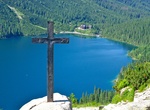
Hike or Horse-Drawn Cart to Morskie Oko, Tatra National Park, Poland
Morskie Oko is the largest and fourth deepest lake in the Tatra Mountains. It is located deep within the Tatra National Park, Poland, in the Rybi Potok Valley, at the base of the Mięguszowiecki Summits, in Lesser Poland Voivodeship. Morskie Oko has been recognized by the journalists of The Wall Street Journal as one of the five most beautiful lakes in the World. Morsk...


Price: $144.00