Give us feedback!


 See all

Our philosophy is simple. We want to encourage you to dream. BIG! Then we help you plan your trip, get the most out of it while you're traveling and help you share your experience with friends.
Join Now It's FREE
Dream Packages
Duration: 3 hours
Price: $180.00
Price: $180.00
Duration: 5 hours
Price: $106.33
Price: $106.33
Duration: 2 days
Price: $242.00
Price: $242.00
Duration: 8 hours
Price: $208.72
Price: $208.72
Dreams Still To Do
Checked-Off Dreams
Dreams Still To Do
Checked-Off Dreams
Advertisement
Explore Adventure Sports
-
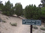
Hike Mountain View Nature Trail, Great Basin National Park, Nevada
This is a leisurely walk in the pinyon-juniper forest. The trail guide (available for loan at the visitor center desk) describes the geology and ecology of the area. The trail starts at the Rhodes Cabin next to the Lehman Caves Visitor Center. -
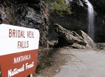
Drive Mountain Waters Scenic Byway, North Carolina
The Mountain Waters Scenic Byway is a two-lane highway in North Carolina, which travels through the Nantahala National Forest in Macon and Swain County, North Carolina counties. The first part of this 61.3-mile (98.7 km) byway follows the combined route of U.S. 64 and NC 28 from Highlands, North Carolina to Franklin, North Carolina and features views of the Cullasaja ... -
Summit Mount Alava, Tutuila, American Samoa
A hiking trail along the maintenance road leads to the 1,610' summit of Mt. Alava; the trailhead is located at Fagasa Pass, a short drive west of Pago Pago. The hike is 6 miles round trip; allow 3 hours for your hike up and 2 hours for your return to the pass. Source: WikiVoyage -
Summit Mount Anne & Eliza Plateau, Tasmania, Australia (UNESCO Site)
Mount Anne is a mountain in the Southwest National Park in Tasmania, Australia. It is within the UNESCO World Heritage listed Tasmanian Wilderness. Mount Anne is a common bushwalking destination for experienced walkers, the Mount Anne circuit is a 4 day walk that can include summiting Mount Anne Mount Anne is the nineteenth highest mountain in Tasmania, but the highes... -
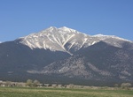
Summit Mount Antero, Sawatch Range, Colorado
Mount Antero is the highest summit of the southern Sawatch Range of the Rocky Mountains of North America. The prominent 14,276-foot (4351.4 m) fourteener is located in San Isabel National Forest, 12.2 miles (19.6 km) southwest by south (bearing 208°) of the Town of Buena Vista in Chaffee County, Colorado, United States. The mountain is named in honor of Chief Ante... -
Hike Mount Apo, Mindanao Island, Philippines
Mount Apo, also known locally as Apo Sandawa, is a large solfataric, dormant stratovolcano on the island of Mindanao, Philippines. With an elevation of 2,954 meters (9,692 ft) above sea level, it is the highest mountain in the Philippine Archipelago and is located between Davao City and Davao del Sur province in Region XI and Cotabato in Region XII. The peak overlooks... -
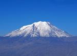
Summit Mount Ararat, Turkey
Mount Ararat is a snow-capped, dormant volcanic cone in Turkey. It has two peaks: Greater Ararat (the tallest peak in Turkey, and the entire Armenian plateau with an elevation of 5,137 m/16,854 ft) and Lesser Ararat (with an elevation of 3,896 m/12,782 ft). The Ararat massif is about 40 km (25 mi) in diameter. The Iran-Turkey boundary skirts east of Lesser Ararat, the... -
Hilke Mount Arthur, Kahurangi National Park, New Zealand
Mount Arthur is located within Kahurangi National Park in the north western area of the South Island of New Zealand. Nettlebed Cave is in the vicinity of the mountain. And so it has been for eons; the 'Marble Mountains' in Kahurangi National Park west of Nelson are now shot through with holes—some of them pinholes and others hugh caves. -
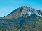
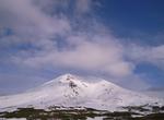
Climb Mount Asahi (Asahidake), Daisetsuzan National Park, Hokkaidō, Japan
Mount Asahi is the tallest mountain in Hokkaidō, Japan. Part of the Daisetsuzan Volcanic Group of the Ishikari Mountains, it is located in the northern part of the Daisetsuzan National Park. The mountain is popular with hikers in the summer and can be easily reached from Asahidake Onsen via Asahidake Ropeway. Sugatami Pond, directly below the peak, is famous for its r... -
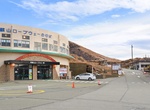
Ride Mount Aso Ropeway, Aso, Kumamoto
The Mt. Aso Ropeway is Japanese aerial lift line in Aso, Kumamoto, operated by Kyūshū Sankō Tourism. It was opened in 1958, and climbs Mount Aso. Its official website claims it was the first aerial lift in the world to be built on an active volcano. The ropeway is currently closed as a result of damaged sustained during the 2016 Kumamoto earthquakes and a shuttle bus ... -
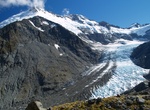
Summit Mount Aspiring (Tititea), New Zealand
Mount Aspiring / Tititea is New Zealand's highest mountain outside the Aoraki/Mount Cook region. Set within Otago's Mount Aspiring National Park, it has a height of 3,033 metres (9,950 feet). Māori named it Tititea, which translates as Glistening Peak. Named in December 1857 by the Chief Surveyor for the Otago Province, John Turnbull Thomson. It is also often called '... -
Explore Mount Auburn Cemetery, Massachusetts
Mount Auburn Cemetery in Massachusetts, was founded in 1831 as "America's first garden cemetery" or "rural cemetery". With classical monuments set in a rolling landscaped terrain, it marked a distinct break with Colonial-era burying grounds and church-affiliated graveyards. The appearance of this type of landscape coincides with the rising popularity of the term "ceme... -
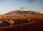
Explore Mount Augustus National Park, Western Australia
Mount Augustus National Park north of Perth, east of Carnarvon and northwest of Meekatharra, in the Gascoyne region of Western Australia. Mount Augustus itself, the feature around which the national park is based, is known as Burringurrah to the local Wadjari Aboriginal people. Mount Augustus is an inselberg that stands 1106 m above sea level, or approximately 860 m a... -
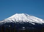
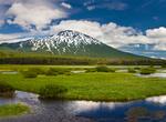
Ski or Snowboard Mount Bachelor, Oregon
Mount Bachelor ski area is a ski resort located in central Oregon, approximately 22 miles (35 km) west of Bend. The ski runs are on the northern face of Mount Bachelor, a stratovolcano built atop a volcanic shield in the Cascade Range. The mountain is famous for its dry snow with typical snowfall of over 350 inches (890 cm) per year and a mid-winter base over 100 inch... -
Explore Mount Bachelor, Oregon
Mount Bachelor, formerly named Bachelor Butte, is a stratovolcano atop a shield volcano in the Cascade Volcanic Arc and the Cascade Range of central Oregon. The Mount Bachelor ski area has operated on the mountain since 1958. Mount Bachelor ski area operates a chairlift during the summer as well as during the ski season (weather permitting). The resort is one of the l...

Price: $176.03