Give us feedback!


 See all

Our philosophy is simple. We want to encourage you to dream. BIG! Then we help you plan your trip, get the most out of it while you're traveling and help you share your experience with friends.
Join Now It's FREE
Dream Packages
Duration: 5 hours
Price: $106.33
Price: $106.33
Duration: 8 hours
Price: $220.83
Price: $220.83
Duration: 8 hours
Price: $208.72
Price: $208.72
Duration: 6 days
Price: $606.00
Price: $606.00
Dreams Still To Do
Checked-Off Dreams
Dreams Still To Do
Checked-Off Dreams
Advertisement
Explore Adventure Sports
-
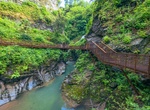
Hike Orrido di Bellano, Lake Como, Italy
Lake Como gorge that is deep and narrow with waterfall. Accessible by a suspension bridge. Orrido ("gorge" or small canyon) was formed through erosion by the river Pioverna. The erosion started 15 million years ago. -
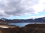
Explore Öskjuvatn Lake, Iceland
Öskjuvatn is a lake in the Highlands of Iceland. Its surface area is about 11 km². With a depth of 217 m (712 ft), it is the second deepest lake in Iceland after Jökulsárlón. The lake is situated in the crater of the volcano Askja in the north-east of the glacier Vatnajökull. Its name simply means thelake of Askja. Like the neighbouri... -
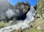
Hike to Osprey Falls, Yellowstone National Park, California
Osprey Falls is a waterfall on the Gardner River in northwestern Yellowstone National Park in the United States. Osprey Falls has a drop of approximately 150 feet (46 m). The falls are located within Sheepeater Canyon and are reachable via the Osprey Falls trail. Follow Old Bunsen Peak Road through grassland and burned forest 3 miles (4.9 km) to Osprey Falls Trail. De... -
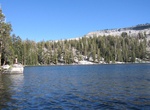
Hike to Ostrander Lake, Yosemite National Park
Ostrander Lake is located in Yosemite National Park, approximately 10 miles (16 km) south of Yosemite Valley and 10 miles (16 km) east of the Badger Pass Ski Area, at an elevation of 8,500 feet (2,600 m). The hike to Ostrander Lake is a long and strenuous 12.7 miles (20.4 km) roundtrip hike starting from the trailhead located just after Bridalveil Creek on the Glacier... -
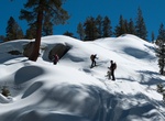
Cross Country Ski to Ostrander Ski Hut, Yosemite National Park
Ostrander Lake is located in Yosemite National Park, approximately 10 miles (16 km) south of Yosemite Valley and 10 miles (16 km) east of the Badger Pass Ski Area, at an elevation of 8,500 feet (2,600 m). The lake is a popular destination for cross-country skiers during the winter. It is the primary source of Bridalveil Creek, which feeds Bridalveil Falls. The Ostrand... -
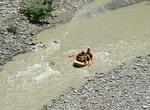
Whitewater Raft or Kayak Osumi Canyons, Albania
Osumi Canyons is located in the region of Skrapar, not far from the city of Berat. -
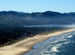
Surf Oswald West State Park, Oregon
Oswald West State Park is part of the state park system of the U.S. state of Oregon. It is located about 10 miles (16 km) south of the city of Cannon Beach, on the Pacific Ocean. Oswald West has unique walk-in access, with wheelbarrows provided by the parks system for transporting gear from the parking area to the 30 primitive camping sites, which are one third of a m... -
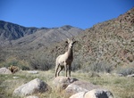
Hike Oswit Canyon, Palm Springs, California
This untouched oasis is home to an impressive variety of flora and fauna, including rare plant species, migratory birds, and desert wildlife. Home to endangered bighorn sheep, mountain lions, bobcats, and others! -
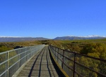
Hike or Ride Otago Central Rail Trail, New Zealand
The Otago Central Rail Trail is a 150-kilometre walking, cycling and horse riding track in the South Island of New Zealand. A pioneering project for New Zealand, the successful cycle trail joined the New Zealand Cycle Trail umbrella organisation in 2012, having been one of the inspirations for it. The trail runs in an arc between Middlemarch and Clyde, along the route... -
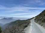
Off-road Otay Mountain Truck Trail (Otay Mountain Wilderness), San Diego, California
The Otay Mountain Truck Trail travels on the ridge tops of the San Ysidro Mountains and is frequented by the friendly U.S. Border Patrol as one can view the international border, San Diego Bay and San Ysidro Mountains. This is a popular off-road driving area. The Otay Mountain Wilderness is a U.S. Wilderness Area located in San Diego County, California, 12 miles eas... -
Off-road Otay Truck Trail, San Diego, California
The Otay Truck Trail is a shortern section near the main Otay Mountain Truck Trail. It connects the northern entance of Otay Mountain Truck Trail next to the Pio Pico RV Resort & Campground with Route 94 in Sycamore Canyon. -
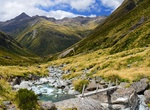
Hike Otira Valley Track, Arthur's Pass, New Zealand
Follow a deep alpine valley under the northern flank of Mount Rolleston/Kaimatau to the Otira River footbridge. -
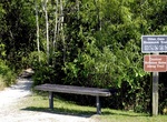
Hike Otter Cave Hammock Trail, Everglades National Park, Florida
A rough limestone trail through a tropical hardwood forest with small footbridges over a small stream. Check at the Shark Valley Visitor Center for current conditions of trail, it sometimes can be flooded during the summer. Begins 0.5 miles (800 meters) behind the Shark Valley Visitor Center, off the Tram Road. -
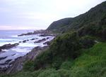
Hike Otter Trail, Garden Route, South Africa
The Otter Trail is a hiking trail along the Garden Route coast of South Africa and is named for the Cape Clawless Otter which occurs in this region. This trail is widely regarded as one of the finest in the world and stretches from Storms River Mouth in the east to Nature's Valley in the west, is 26 km long as the crow flies and 41 km as the hiker walks. Walking the t... -
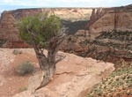
Hike Otto's Trail, Colorado National Monument, Colorado
Gently sloping trail that leads through pinyon-juniper woodlands to an overlook with views of Sentinel Spire, Pipe Organ, Praying Hands, and Independence Monument. Location: From Saddlehorn Visitor Center, turn left onto Rim Rock Drive and proceed 1.0 mile (1.6 km) to the trailhead onthe left.
Price: $242.00