Give us feedback!


 See all

Our philosophy is simple. We want to encourage you to dream. BIG! Then we help you plan your trip, get the most out of it while you're traveling and help you share your experience with friends.
Join Now It's FREE
Dream Packages
Duration: 8 hours
Price: $208.72
Price: $208.72
Duration: 9 hours
Price: $109.14
Price: $109.14
Duration: 3 hours 30 minutes
Price: $99.36
Price: $99.36
Duration: 7 hours
Price: $179.00
Price: $179.00
Dreams Still To Do
Checked-Off Dreams
Dreams Still To Do
Checked-Off Dreams
Advertisement
Explore Adventure Sports
-
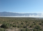
Explore Owens Lake, California
Owens Lake is a mostly dry lake in the Owens Valley on the eastern side of the Sierra Nevada in Inyo County, California. It is about 5 miles (8.0 km) south of Lone Pine, California. Unlike most dry lakes in the Basin and Range Province that have been dry for thousands of years, Owens held significant water until 1913, when much of the Owens River was diverted into the... -
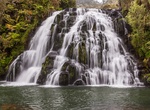
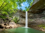
See Owharoa Falls, New Zealand
Owharoa Falls is a staircase waterfall in New Zealand, near Karangahake Gorge and SH 2 between Paeroa and Waihi on Waitawheta Road. -
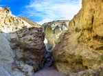
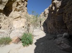
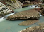
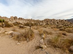
See Owl Canyon, Rainbow Basin, California
Owl Canyon is a beautiful and colorful canyon within Rainbow Basin Natural Area. It's mostly just a sandy drainage, but there was some Class 2 boulder-hopping. The badlands toward the head of the canyon were a little more difficult to navigate since trails lead in different directions. -
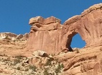
Hike Owl Creek to Nevills Arch, Cedar Mesa, Utah
These drainages both cut diagonally across the eastern edge of Cedar Mesa, coming together several miles before they enter Comb Wash. Both are deep canyons with abundant geolgical features. Maps needed for this area are either the Trails Illustrated Grand Gulch Plateau map, or the following USGS 7.5 quads: South Long Point, Bluff NW, and Snow Flat Spring Cave. Many o... -
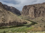
Raft or Kayak Owyhee River, Idaho
The Owyhee River Wilderness is located on the high basalt plateaus of Owyhee County in southwestern Idaho in the western United States. Whitewater rafting is a popular recreational activity in this wilderness area. The wilderness area is named after and protects the upper Owyhee River, its tributaries, and the surrounding desert canyon landscape. Whitewater rafting is... -
Hike Oxbow Overlook Trail, Katmai National Park, Alaska
Oxbow Overlook Trail is a 0.5 mile out and back trail located near Brooks Camp in Katmai National Park. -
Drive Oxon Run Parkway, Washington, D.C.
The Oxon Run Parkway, is a roadway and small park in the Washington Highlands neighborhood of Washington, D.C.. 126 acres (51 ha) of important wetlands and deciduous forest is located in this urban environment. Only a single road, managed by the National Park Service, traverses the area, which is meant to demonstrate how a relatively wooded and pristine environment ca... -
Hike Oyster Shell Wash, Anza-Borrego Desert State Park, California
Oyster Shell wash entrance is near the Wind Caves along Fish Creek in Anza-Borrego Desert State Park. The wash and it's fork are rugged steep canyons. To get to the trailhead a higher clearance car is essential and might need 4WD. -
Hike Along the Ozark Highlands Trail, Arkansas
The Ozark Highlands Trail roams 218 miles (351 km) through parts of seven counties in northwest Arkansas. It stretches from Lake Fort Smith State Park, across the Ozark National Forest, to the Buffalo National River. The trail passes through some of the most remote and scenic portions of the Ozark Mountains, like the Hurricane Creek Wilderness Area. It also crosses Wh... -
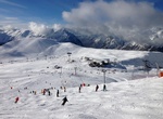
Ski or Snowboard Oz-en-Oisans, France
Oz-en-Oisans in the French Alps is a small, pretty, traffic-free ski resort. It's great for great for children and beginners. -
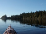
Kayak Ozette Lake, Olympic National Park, Washington
Ozette Lake is the largest unaltered natural lake in Washington state at 29.5 km² (2,954 ha). The Makah name for Lake Ozette wasKahoukmeaning "large lake." Eight miles long and three miles wide, Ozette Lake is contained within the northern boundary of the Olympic National Park's coastal strip. It is 29 feet (~9 m) above sea level and is drained by the Ozette Rive... -
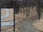
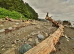
Hike Ozette Loop, Olympic National Park, Washington
The Ozette Loop combines the Sand Point Trail and theCape Alava Trail with a 2.9 mile beach walk to connect the two trails. Permits/Reservations: Reservations are required for camping in the Ozette area between May 1 and September 30. In the off-season, permits can be picked up at the WIC in Port Angeles. Group Size: Groups are limited to 12 people. Associated group... -
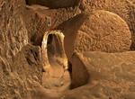
Visit Özkonak Underground City, Turkey
Özkonak Underground City is an ancient city built on the northern slopes of Mt. Idis about 14 km northeast of Avanos in Turkey. The city has many strata made up of volcanic granite its larger areas are connected to each other by tunnels. Özkonak had a built in communication system of pipes to each of its levels, unlike Kaymaklı and Derinkuyu which have no su... -
Hike to Ozone Falls, Tennessee
Ozone Falls is a waterfall located in Cumberland County, Tennessee in the Ozone Falls State Natural Area and Cumberland Trail State Park. Ozone Falls is situated along Fall Creek, which drains a short section of the Cumberland Plateau between the Crab Orchard Mountains to the west and Walden Ridge to the east. The creek flows down from its source high in the Crab Orch... -
Hike Paac Kü̱vü̱hü̱’k, Joshua Tree National Park, California
The trailhead to Paac Kü̱vü̱hü̱’k is 5 miles (8 km) from the start of Geology Tour Road. 4-wheel drive is recommended; high clearance necessary beyond Paac Kü̱vü̱hü̱’k.
Price: $140.24