Give us feedback!


 See all

Our philosophy is simple. We want to encourage you to dream. BIG! Then we help you plan your trip, get the most out of it while you're traveling and help you share your experience with friends.
Join Now It's FREE
Dream Packages
Duration: 4 hours 30 minutes
Price: $176.03
Price: $176.03
Duration: 7 hours
Price: $144.00
Price: $144.00
Duration: 9 hours
Price: $109.14
Price: $109.14
Duration: 8 hours
Price: $220.83
Price: $220.83
Dreams Still To Do
Checked-Off Dreams
Dreams Still To Do
Checked-Off Dreams
Advertisement
Explore Adventure Sports
-
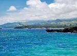
Visit Pujada Bay, Mindanao Island, Philippines
Pujada Bay is a bay on the Pacific coast of the southern Philippine island of Mindanao. It is an arm of the Philippine Sea in Davao Oriental province formed by the Guanguan Peninsula which separates it from the Mayo Bay on the east and the Pujada Peninsula which separates it from the Davao Gulf on the west. Pujada Bay borders Mati, the province's capital and largest c... -
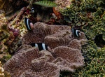
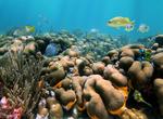
Dive or Snorkel Pulau Misool Nature Reserve, Indonesia
Pulau Misool Nature Reserve was established in 1982. It covers the southern portion of the island, with an area of 840 km2. Misool and the Raja Ampat Islands are part of the Coral Triangle, and islands' coral reefs and coastal waters are some of the most biodiverse on Earth. Native fish include the Misool rainbowfish (Melanotaenia misoolensi... -
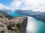
Stand on Pulpit Rock (Preikestolen), Norway
Preikestolen or Prekestolen, also known by the English translations of Preacher's Pulpit or Pulpit Rock, and by the old local name Hyvlatonnå (“the carpenter-plane’s blade”), is a massive cliff 604 metres (1982 feet) above Lysefjorden, opposite the Kjerag plateau, in Forsand, Ryfylke, Norway. The top of the cliff is approximately 25 by 25 metre... -
Explore Pulu Keeling National Park, Australia
North Keeling is a small, uninhabited coral atoll, approximately 1.2 square kilometres (0.46 sq mi) in area, about 25 kilometres (16 mi) north of Horsburgh Island. In 1986, an agreement was reached between the Australian National Parks and Wildlife Service and the Cocos Malay people to restrict and sustainably manage any further hunting on North Keeling. In 1989 Cyclo... -
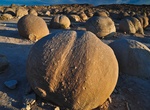
Visit Pumpkin Patch, Ocotillo Wells, California
Pumpkin Patch is located within Ocotillo Wells State Vehicular Recreation Area. It can be accessed via the Arroyo Salado Trail, Cut Across Trail or from a few trails from Ocotillo Wells. Pumpkin Patch is a remote field of round rocks is a popular destination in Ocotillo Wells. Created long ago when the climate here was wet, then shaped through years of erosion, the ... -
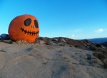
Hike Pumpkin Rock Trail, Norco, California
This 1.7-mile loop trail has a rock painted like a large jack-o'-lantern, this rock sits at the top of a hill with sweeping views. -
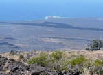
Hike Puna Coast Trail, Hawaii Volcanoes National Park, Big Island, Hawaii
Puna Kau Trail is a 18.3 mile out and back trail located in Hawaii Volcanoes National Park. The trail is rated as difficult and can be accessed via Chain of Craters Road. -
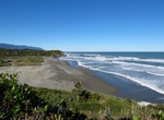
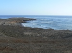
Visit Punakaiki Beach, New Zealand
Punakaiki is a small community on the West Coast of the South Island of New Zealand, between Westport and Greymouth. The community lies on the edge of the Paparoa National Park. The Little Blue Penguin (Korora)is the world's smallest penguin and you can often spot them coming ashore at night along much of the West Coast near Punakaiki. ThePancake Rocksare a very popul... -
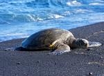
See Punaluʻu Beach, Big Island, Hawaii
Punaluʻu Beach (also called Black Sand Beach) is a beach between Pāhala and Nāʻālehu on the Big Island of the U.S. state of Hawaii about 30 miles south of Hawaii Volcanoes National Park. The beach is a great place to see Hawaiian green sea turtles basking on the shore. The beach has black sand made of basalt and created by lava flowing into the ocean which explodes as... -
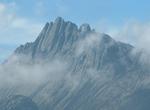
Summit Puncak Jaya (Carstensz Pyramid), Indonesia
Puncak Jaya, sometimes called Mount Carstensz or the Carstensz Pyramid, is a mountain in the Sudirman Range, the western central highlands of Papua province, Indonesia (within Puncak Jaya Regency). Other names include Nemangkawi in the Amungkal language, Ngga Pulu, Carstensz Toppen and Gunung Sukarno. At 4,884 metres (16,024 ft) above sea level, Puncak Jaya is the hig... -
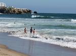
Surf Punta Baja, Baja California, Mexico
Punta Baja offers an excellent right point break and no crowds. It's located south of El Rosario and is hard to get to. There are are little to no accomodations nearby. On a good west or southwest swell, mostly summertime Punta Baja is a great. -
Visit Punta Cana, Dominican Republic
Punta Cana is the name of a region in the easternmost tip of the Dominican Republic. The region is home to a coastline of sandy white beaches and to a "town" of the same name. Located in the province of La Altagracia and population estimated at 100,000, the region borders the Atlantic Ocean to the east. To the north, it borders Bávaro and El Cortecito beaches. ... -
Surf Punta Carnero, Ecuador
Punta Carnero is a beach located in the Salinas County, in the Santa Elena Province of Ecuador. Its name, “Ram Point” in English, stems from the rocky headland located at the southeast end of the beach. The quality of the surf from the rocks to the dock Ecuasal is the reason why many surfers turn to this beach for the sport. Punta Carnero Beach is surround... -
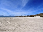
Visit Punta Chivato, Baja California Sur, Mexico
Punta Chivato is a small community of homes and lots with a private airstrip located on the Sea of Cortez. Punta Chivato is 23.9 mi (38.5 km) from Mulege Museum and 24.4 mi (39.2 km) from Santa Rosalia de Mulege Mission. The beach offers a great place to camp on the Sea of Cortez. -
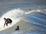
Surf Punta del Diablo, Uruguay
The surf breaks off Punta Diablo's beaches offer relatively consistent and uncrowded surf. Best conditions are in the autumn and winter with high season running from December to February. Visitors can rent or purchase surf boards at the Surf Shop on, Main Road.
Price: $173.83