Give us feedback!


 See all

Our philosophy is simple. We want to encourage you to dream. BIG! Then we help you plan your trip, get the most out of it while you're traveling and help you share your experience with friends.
Join Now It's FREE
Dream Packages
Duration: 2 days
Price: $242.00
Price: $242.00
Duration: 8 hours
Price: $220.83
Price: $220.83
Duration: 3 hours
Price: $180.00
Price: $180.00
Duration: 15 hours
Price: $149.00
Price: $149.00
Dreams Still To Do
Checked-Off Dreams
Dreams Still To Do
Checked-Off Dreams
Advertisement
Explore Adventure Sports
-
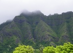
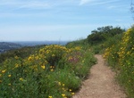
Hike Pu'u Manamana Turnover Trail (Crouching Lion), Oahu
Pu'u Manamana Turnover Trail is a 3.7 mile loop trail located near Hauula, Hawaii. The trail is only recommended for very experienced adventurers since it's one of the most difficult and treacherous hikes on the island of Oahu. The trail goes up to the rock formation known as Crouching Lion and then follows a ridgeline. -
Hike Pu‘u o Lokuana Trail, Kahuku Unit, Hawaii Volcanoes National Park, Hawaii
Pu‘u o Lokuana Trail is a short trail located in the Kahuku Unit of Hawaii Volcanoes National Park off Kahuku Road. -
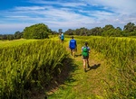
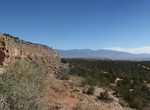
Drive Puyé Scenic Byway, New Mexico
Puyé Scenic Byway is 14miles (22.5km) route out and back that travels through a diverse landscape and exemplifes the natural wonders of New Mexico. It ends at the towering heights of Puye Cliff Dwellings, a National Historic Landmark. -
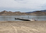
Visit PWC Beach and Fishing Pier, Lake Mead, Nevada
Bring your beach chairs and umbrella to PWC Beach and Fishing Pier. There’s plenty of sand for relaxing and calm water for swimming. Just watch out for fishing lines near the Fishing Pier. Access: PWC Beach/Fishing Pier is located west of Hemenway Cove Ramp on Lake Mead. The dirt road to the beach is located at the top of the ramp. TIPS: Bring chairs ... -
Summit Pyle’s Peak, Mission Trails Park, California
Pyles Peak Trail is a 5.6-6.8 miles out and back trail located in Mission Trails Regional Park. The moderate hike offers scenic views, you can hike or trail run. The trail is open from October until June. The hike allows leashes dogs. This trail is one of the 5-Peak Challenge trails. Take a photo at the summit at each of the trails and show it to the Mission Trails P... -
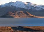
Explore Pyramid Lake, Nevada
Pyramid Lake is the geographic sink of the Truckee River Basin and is located 40 mi (64 km) northeast of Reno. The inflow is moderately high silt-loaded surface runoff. Pyramid Lake is fed by the Truckee River after leaving Lake Tahoe and enters the lake from its southern end. There is no outlet, with water leaving only by evaporation, or sub-surface seepage (an Endor... -
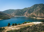
Explore Pyramid Lake, Castaic, Southern California
Pyramid Lake is a reservoir formed by Pyramid Dam on Piru Creek in the eastern San Emigdio Mountains, near Castaic, Southern California. It is a part of the West Branch California Aqueduct, which is a part of the California State Water Project. Its water is fed by the system after being pumped up from the San Joaquin Valley and through the Tehachapi Mountains. The 386... -
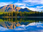
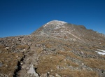
Summit Pyramid Mountain, Jasper National Park, Canada
Pyramid Mountain is a mountain in Jasper National Park, Alberta, Canada, named for its pyramid-like shape. James Hector named the mountain in 1859 due to its appearance from the Athabasca River valley on the eastern side of the peak. Part of the Victoria Cross Ranges in the Athabasca River Valley the mountain is in the major headwater for the Athabasca River. The peak... -
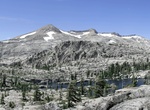
Summit Pyramid Peak, California
Pyramid Peak is a mountain in the California's Sierra Nevada in the Crystal Range and to the west of Lake Tahoe. With an elevation gain of almost 4,100 feet (1,250 m), the Rocky Canyon route is the mountain's most popular approach although it is very arduous. To the east, at the base of the peak, lies Pyramid Lake. -
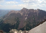
Summit Pyramid Peak, Elk Mountains, Colorado
Pyramid Peak is a fourteen thousand foot mountain in the U.S. state of Colorado. It is the 47th highest mountain peak in Colorado, and 78th highest peak in the United States. It is located in the Elk Mountains in southeastern Pitkin County, approximately 12 miles (19 km) southwest of Aspen. The summit somewhat resembles a ragged square pyramid and is visible from the ... -
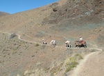
Hike Qhapaq Ñan (Andean Road System), South America (UNESCO Site)
The Inca road system was the most extensive and advanced transportation system in pre-Columbian South America. The construction of the roads required a large expenditure of time and effort, and the quality of that construction is borne out by the fact that it is still in quite good condition after over 400 years of use. The network was based on two north-south roads w... -
Hike to Quail Springs Reservoir, Joshua Tree National Park, California
Hike to the old reservoir at Quail Springs in Joshua Tree National Park, California. Hike for 3.3 miles form Quail Springs Trailhead keeping the mountain to your left. Then head up the creek for 500 yeards to the reservoir. -
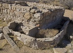
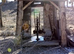
Hike Quail Springs Trail to The Pump House (Howard's Well), Joshua Tree National Park
The Quail Springs Trail starts at the Quail Springs Picnic Area in Joshua Tree National Park. It's a great spot to stage a hike out into the desert. Out in the middle of the desert is the Pump House. The pump still works, bringing up cool, clear water which is then piped to a small water trough in front of the structure. The Quail Springs pumphouse is in a bit of dis... -
Summit Quandary Peak, Tenmile Range, Colorado
Quandary Peak is the highest summit of the Tenmile Range in the Rocky Mountains of North America and is the most commonly climbed fourteener in Colorado. It has nearly the same elevation as Castle Peak and Mount Evans. It lies in Summit County and within the White River National Forest about 6 miles (10 km) south-southwest of the town of Breckenridge. The standard rou... -
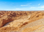
Off-road Quarry Road, Ocotillo Wells SVRA, California
Quarry Road is a well-graded dirt road within the Ocotillo Wells State Vehicular Recreation Area (SVRA) in California. It provides access to various terrains, including the Shell Reef, a unique geological formation with fossilized seashells embedded in stone. The road is also a gateway to other areas like the San Felipe Wash and the Borrego Sink. The road starts o...
Price: $606.00