Give us feedback!


 See all

Our philosophy is simple. We want to encourage you to dream. BIG! Then we help you plan your trip, get the most out of it while you're traveling and help you share your experience with friends.
Join Now It's FREE
Dream Packages
Duration: 3 hours
Price: $173.83
Price: $173.83
Duration: 6 days
Price: $606.00
Price: $606.00
Duration: 4 hours
Price: $120.43
Price: $120.43
Duration: 2 days
Price: $242.00
Price: $242.00
Dreams Still To Do
Checked-Off Dreams
Dreams Still To Do
Checked-Off Dreams
Advertisement
Explore Adventure Sports
-
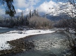
Hike Queets River Trail, Olympic National Park, Washington
The Queets River Trail is 15.8 miles to end of trail. A river ford is required to access the Queets from the trailhead. This crossing can be difficult or impossible during periods of heavy rain or snow melt. It is commonly waist deep in summer. The Lower Queets Road provides access as far as Matheny Creek; the road is closed beyond that due to a major land slide. The ... -
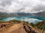
Drive Quilotoa Loop, Ecuador
The Quilotoa Loop (or Quilotoa circuit) is a remote, bumpy, mountainous road linking several high Andean villages and towns with the city of Latacunga. It offers one a chance to get off the Pan American highway and see some of the more remote people and culture of the central Andes of Ecuador. Towns along the route include: Latacunga Saquisilí Chugchil&aa... -
Hike Quinault Loop Trail, Olympic National Park, Washington
Quinault Loop Trail is a 3.9 mile loop trail located near Quinault Ranger Station and Quinault Lodge. -
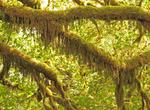
Explore Quinault Rain Forest, Olympic National Park, Washington
The Quinault Rain Forest is a temperate rain forest, which is part of the Olympic National Park and the Olympic National Forest in the U.S. state of Washington in Grays Harbor County and Jefferson County. The rain forest is located in the valley formed by the Quinault River and Lake Quinault. The valley is called the "Valley of the Rain Forest Giants" because of the n... -
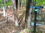
Hike Quinnipiac Trail, Connecticut
The Quinnipiac Trail is a 24-mile Blue-Blazed hiking trail in New Haven County, Connecticut. It is the product of the evolution and growth of the first 10.6-mile (17.1 km) trail designated in Connecticut's Blue-Blazed Hiking Trail system, with its light-blue rectangular vertical painted blazes . From its southeastern trailhead, its easternmost leg runs northward, para... -
Dive Quirimbas Islands, Mozambique
The Quirimbas Islands lie in the Indian Ocean off northeastern Mozambique. The archipelago consists of about 27 islands, including Ibo, Matemo, Medjumbe, Quirimba, Quisiva and Rolas Island. These islands are known for their high-quality diving sites, including phenomenal drop-offs, some up to 400 meters. The Quirimbas National Park, spanning an area of 7 500 km²... -
Summit Quitaraju, Huascarán National Park, Peru
Quitaraju or Kitaraju (possibly from Ancash Quechuakitadam, Quechuarahusnow, ice) is a mountain in the Cordillera Blanca in the Andes of Peru, about 6,040 metres (19,816 ft) high. It is situated in the Ancash Region, Huaylas Province, Santa Cruz District. Quitaraju lies north of the Santa Cruz Creek and the lakes named Ichiccocha, Jatuncocha and Quitacocha, between Sa... -
Snorkel Quobba Aquarium, Macleod, Western Australia
One kilometre south of the Quobba Blowholes is a calm coral-filled lagoon known to the locals as the 'Aquarium', with fish and shells in abundance and a white sandy beach, making it a perfect hangout spot for the family. The lagoon is an ideal spot for snorkelling, especially for those least confident in the water. -
Explore Quttinirpaaq National Park "top of the world", Nunavut, Canada
Quttinirpaaq National Park is a Canadian national park. Located on the northeastern corner of Ellesmere Island in the Qikiqtaaluk Region of Nunavut, the most northerly extent of Canada, it is the second most northerly park on Earth after Northeast Greenland National Park. In Inuktitut, Quttinirpaaq means "top of the world". It was established as Ellesmere Island Natio... -
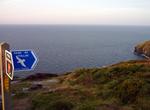
Hike Raad ny Foillan (The Way of the Gull), Isle of Man
Raad ny Foillan (The Way of the Gull) is a long distance footpath in the Isle of Man. The Raad ny Foillan starts and finishes at the Millennium Bridge over Douglas Harbour. The circular path, which is 95 miles in length, is way marked around the Manx coast on signs showing a gull on a blue background. The walk was created to mark the Island's "Heritage Year" celebrati... -
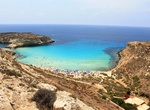
Relax on Rabbit Beach, Lampedusa Island, Italy
Rabbit Beach has crystal clear water and white sandy. It is located in the southern part of Lampedusa island in Italy. In 2013 it was voted the world's best beach by travel site TripAdvisor. Climb over he rocks to the side of the beach where the large rocks provide for some space away from the crowds. Hours are 8:30 - 19:30 and it does get crouded so get there early ... -
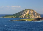
Kayak around Rabbit (Mānana) & Kāohikaipu Islands, Oahu, Hawaii
Mānana Islandis an uninhabited islet located 0.75 mi (1.21 km) off Kaupō Beach, near Makapuʻu at the eastern end of the Island of Oʻahu in the Hawaiian Islands. In the Hawaiian language, mānana means "buoyant". The islet is commonly referred to asRabbit Island, because its shape as seen from the nearby Oʻahu shore looks something like a rabbit's head and because it wa... -
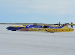
Attend Race at Bonneville Speedway, Utah
Bonneville Speedway is an area of the Bonneville Salt Flats near Wendover, Utah, that is marked out for motor sports. It is particularly noted as the venue for numerous land speed records. The salt flats were first used for motor sports in 1912, but didn't become truly popular until the 1930s when Ab Jenkins and Sir Malcolm Campbell competed to set land speed records.... -
Attend Race at Darlington Raceway, South Carolina
Darlington Raceway is a race track built for NASCAR racing located near Darlington, South Carolina. It is nicknamed "The Lady in Black" and "The Track Too Tough to Tame" by many NASCAR fans and drivers and advertised as "A NASCAR Tradition." It is of a unique, somewhat egg-shaped design, an oval with the ends of very different configurations, a condition which suppose... -
Attend Race at Talladega Superspeedway
Talladega Superspeedway (nicknamed "the Big One") is a motorsports complex located north of Talladega, Alabama, United States. It is located on the former Anniston Air Force Base just outside the small city of Lincoln. It was constructed by International Speedway Corporation, a business controlled by the France Family, in the 1960s. Talladega is most known for its ste...


Price: $208.72