Give us feedback!


 See all

Our philosophy is simple. We want to encourage you to dream. BIG! Then we help you plan your trip, get the most out of it while you're traveling and help you share your experience with friends.
Join Now It's FREE
Dream Packages
Duration: 4 hours 30 minutes
Price: $176.03
Price: $176.03
Duration: 3 hours 30 minutes
Price: $99.36
Price: $99.36
Duration: 3 hours
Price: $140.24
Price: $140.24
Duration: 8 hours
Price: $220.83
Price: $220.83
Dreams Still To Do
Checked-Off Dreams
Dreams Still To Do
Checked-Off Dreams
Advertisement
Explore Adventure Sports
-
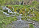
Visit Rossbeigh Beach, Ireland
Rossbeigh is a beach, approximately 1.6 km from the village of Glenbeigh, in County Kerry, Ireland. It is on the Ring of Kerry on the Iveragh Peninsula. Rossbeigh is part of the Castlemaine Harbour Special Area of Conservation, Special Protection Area, and proposed Natural Heritage Area (pNHA). These organisations consider Rossbeigh an important habitat for flora... -
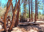
Walk to Ross Grave, Holcomb Valley, California
Ross' Grave is stop #9 of the Gold Fever Trail near Big Bear Lake. The grave is for a person named Ross, but not much is know of the person. It’s about 200 yards hike to this spot. -
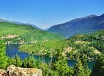
Explore Ross Lake National Recreation Area, Washington
Ross Lake National Recreation Area is a US National Recreation Area located in north central Washington just south of the Canadian border. It is the most accessible part of the North Cascades National Park Service Complex which also includes North Cascades National Park and Lake Chelan National Recreation Area. Ross Lake NRA follows the Skagit River corridor from the ... -
Walk Roter Faden (Red Thread), Hanover, Germany
The Red Thread (German:Roter Faden) is a 4.2-kilometre (2.6 mi) urban walking trail in Hanover, Germany, to 36 significant points of interest about architecture and the history of the city centre. It starts at Ernst August Square next to the tourist information office, approximately 120 metres (390 ft) south-southeast of the southern, ground level, entrance of the mai... -
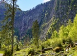
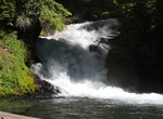
Hike to Röthbachfall, Berchtesgaden National Park, Germany
The Röthbachfall (Röthbach Waterfall) is the highest waterfall in Germany, with a vertical drop of 470 metres (1540 ft). The waterfall is located in the Berchtesgaden area on the Obersee lake. One way to visit the waterfall is to take the electric boat across lake Königssee to Salet and then to hike up to the Obersee. This remote location has led to the... -
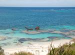
Dive Rottnest Island Shipwrecks, Western Australia
Since the first Europeans visited the west coast of Australia in the 17th century, Rottnest Island has seen numerous shipwrecks. The 11 kilometre long and 4.5 km wide island is surrounded by hidden and partly exposed reefs whilst being buffeted by the Roaring Forties. It is situated 12 km west of the port of Fremantle meaning that much of the maritime traffic to Weste... -
Hike Roughlock Falls Trail, Spearfish Canyon, South Dakota
The Roughlock Falls Nature Area is located in Spearfish Canyon and is considered one of the most beautiful locations in the Black Hills. The water feeding Roughlock Falls flows into Spearfish Canyon from Little Spearfish Creek. Spearfish Canyon highlights an outdoor wonder that is impressive and unique to the Black Hills. Roughlock Falls is spectacular to view and pho... -
Hike to Rough Rider Falls, Oregon
Rough Rider Falls Trail is a 6.4 mile out and back trail located along the Rough River in Oregon. -
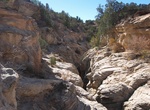
Hike Round Valley Draw, Grand Staircase-Escalante National Monument, Utah
Round Valley Draw is an easy slot canyon to try out. Waters of Round Valley Draw flow south into the larger, wider Hackberry Canyon which then joins Cottonwood Creek. This hike requires a bit of scrambling. There are a couple of dryfalls to overcome but no major obstacles and the most interesting section can be explored in just 2 hours. Reaching the trailhead is gene... -
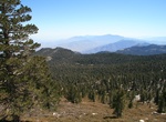
Hike Round Valley Trail, San Jacinto Mountain, California
The Round Valley Trail is located at the top of the Palm Springs Tram in the San Jacinto Mountains. A 2.5 miles one-way of trail leads to picturesque Round Valley. Fairly level trails, short climbs, moderately strenuous. There is a 5 mile loop trail to return. From Round Valley to Wellmans Divide is a 1-mile hike with a 600 feet elevation gain. The view from here is t... -
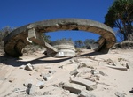
Hike or Off-roadto Rous Battery, Moreton Island, Queensland, Australia
Remains of a World War II fort set high on the islands dunes on Moreton Island. The Rous Battery track starts off The Desert Road and ends at Rous Battery on the eastern beach. You will need a 4WD for driving on the island. Four-wheel-drives with high clearance and low range function are strongly recommended. All-wheel-drive vehicles without true 4WD function and ve... -
Drive Route 395 through Owens Valley, California
Owens Valley is the arid valley of the Owens River in eastern California in the United States, to the east of the Sierra Nevada and west of the White Mountains and Inyo Mountains on the west edge of the Great Basin section. The mountain peaks on either side (including Mount Whitney) reach above 14,000 feet (4,300 m) in elevation, while the floor of the Owens Vall... -
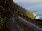
Off-road Route 622 (Svalvogur Road), Westfjords, Iceland
The 22km long Route 622 (Svalvogur road) in Iceland is one of the most dangerous road in the world. It’s located in the Westfjords, a large peninsula in northwestern Iceland. The trail is extreme, just for 4x4 with high ground clearance. Some say it´s the most terrifying road in the country. Rough gravel, and even mud, and you have to go on low tide on the... -
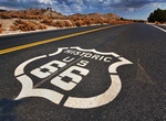
Drive on Route 66
Famous in literature, film and song, US Route 66 originally covered the ground between Chicago, Illinois and Los Angeles, California, a distance of nearly 4,000 kilometers. Route 66 served as the path for those fortune seekers hoping to improve their lives as they migrated west toward California from the Midwest of the United States. As the US Interstate Highway syste... -
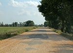
Drive Route 66 Ribbon Road (Sidewalk Road), Oklahoma
The Tarmac section in the middle of the road is the original (1922) 9ft wide, Route 66. It's a rough rough, driving at more than 15mph will shake the car to pieces.


Price: $109.14