Give us feedback!


 See all

Our philosophy is simple. We want to encourage you to dream. BIG! Then we help you plan your trip, get the most out of it while you're traveling and help you share your experience with friends.
Join Now It's FREE
Dream Packages
Duration: 8 hours
Price: $208.72
Price: $208.72
Duration: 15 hours
Price: $149.00
Price: $149.00
Duration: 3 hours
Price: $173.83
Price: $173.83
Duration: 6 days
Price: $606.00
Price: $606.00
Dreams Still To Do
Checked-Off Dreams
Dreams Still To Do
Checked-Off Dreams
Advertisement
Explore Adventure Sports
-
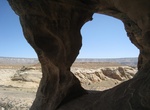
Hike to Ruin Arch, San Rafael Swell, Utah
Ruin Arch is located in the Buckhorn Draw area of the San Rafael Swell. It's a short hike from Buckhorn Draw Rd. The inside of the arch has some interesting petroglyphs. Other petroglyphs can also be found on the opposing back wall of the alcove. -
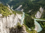
Explore Ruinaulta, Grisons, Switzerland
Ruinaulta is a canyon created by the Anterior Rhine byIlanz/Glion and Reichenau in the debris of the Flims Rockslide just upstream of its confluence with the Posterior Rhine at Reichenau in the Grisons, eastern Switzerland. It is sometimes known as theRhine Gorge, or sometimes rather ironically calledSwiss Grand Canyon. Protected by cliffs several hundred metres high,... -
Visit Ruins of Heracleion, Alexandria, Egypt
Heracleion (Ancient Greek: ἩράκλειονHērákleion), also known as Thonis (Ancient Greek: ΘῶνιςThônis; from the Ancient Egyptian:Tȝ-ḥn.t; Coptic: ⲦϩⲱⲛⲓThōni, Late Coptic [dəˈhoːni]) and sometimes called Thonis-Heracleion, was an ancient Egyptian port city located near the Canopic Mouth of the Nile,... -
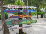
Relax at Rum Point Beach, Grand Cayman, Cayman Islands
Rum Point Beach is located about 45 minutes north from Georgetown on Grand Cayman, Cayman Islands. This is a nice more relaxed place on the island where you can sleep in the hammocks and hang out at the beach bars. -
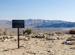
Hike Ruple Point Trail, Dinosaur National Monument, Utah
For most of its length, Ruple Point Trail crosses a rolling terrain filled with sagebrush and juniper. Near the end of the trail, a short descent rewards hikers with a breathtaking views of Split Mountain Canyon and the Green River 2,500 feet (762 meters) below. -
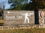
Explore Russell Cave National Monument, Alabama
The Russell Cave National Monument is a U.S. National Monument in northeastern Alabama, United States, close to the town of Bridgeport. The Monument was established on May 11, 1961, when 310 acres of land were donated by the National Geographic Society to the American people. It is now maintained by the National Park Service. With a mapped length of 7.2 miles, Russell... -
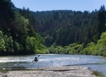
Explore Russian River, California
The Russian River (Southern Pomo:Ashokawna, Spanish:Río Ruso) is a southward-flowing river that drains 1,485 sq mi (3,850 km2) of Sonoma and Mendocino counties in Northern California. With an annual average discharge of approximately 1,600,000 acre feet (2.0 km3), it is the second-largest river (after the Sacramento River) flowing through the nine-county Greate... -
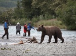
Fish Russian River (Alaska)
The Russian River is a 13-mile-long (21 km) river on the Kenai Peninsula in the U.S. state of Alaska. It flows northward from Upper Russian Lake in the Kenai Mountains through Lower Russian Lake, draining into the Kenai River at the town of Cooper Landing. The native Denaina people called this river Chunuk'tnu. Like the Kenai, the Russian River is famous for its fishi... -
Off-road to Rusty Jeep, Truckhaven Wash, California
Ruins of an old Jeep SUV out in the middle of nowhere. -
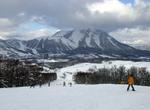
Ski or Snowboard Rusutsu, Hokkaido, Japan
Rusutsu is Hokkaido Japan's third largest ski resort. The resort covers three mountains, West Mountain, East Mountain, and Mount Isola. The total number of runs is 37, the length 42 kilometres (26 mi), vertical rise: 594m; lifts: 18; terrain: beginner 30 per cent, intermediate 40 per cent, advanced 30 per cent.. This is the first Japanese ski resort to be awarded for... -
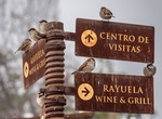
Experience Ruta de los Abastos, Chile
Ruta de los Abastos is a rural culinary experience with local wineries, resturants, beekeepers, oyster farmers and other producers. Located in the O'Higgins Region, in the center of Chile. O'Higgins offers a territory full of magical towns, unique landscapes, ecological and cultural biodiversity. Go to Ruta de los Abastos to see different booking options. -
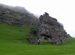
Explore Rutshellir Cave, Skogar, Iceland
Rutshellir Cave is 1 of hundreds of historic man-made caves in Iceland. Rutshellir Cave located about 4.6 km from Skógafoss. Thought to be the oldest extant man-made residence in Iceland. There's an information sign and parking area right off the Ring Rd. -
Hike Ryan Mountain, Joshua Tree National Park, California
Ryan Mountain is a 5,456 feet (1,663 m) high mountain in Joshua Tree National Park. The 1.5 mile trail to the peak is a strenuous hike, but popular attraction of the park, because it leads to panoramic views of Lost Horse Valley, Queen Valley, and Pleasant Valley. It is one of the locations in Joshua Tree that features abundant lichen populations. It is named after J.... -
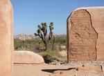
Hike to Ryan Ranch & Lost Horse Well, Joshua Tree National Park
The Ryan Ranch trailhead is about 0.5 mile (0.8 km) east of Ryan Campground. It's an easy hike along an old ranch road and see a historic adobe structure. The Ryan Ranch at Lost Horse Well was connected with both mining and stockraising by Jepp and Tom Ryan. The large abobe home is thoguht to have been built in 2896 and was lived in into the 1930's and beyond. The ra... -
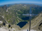
Summit Rysy, Poland & Slovakia
Rysy is a mountain in the crest of the High Tatras, lying on the border between Poland and Slovakia. Rysy has three peaks: the middle at 2,503 m (8,212 ft); the north-western at 2,499 m (8,199 ft); and the south-eastern at 2,473 m (8,114 ft). The north-western peak is the highest point of Poland; the other two peaks are on the Slovak side of the border, in the Pre&sca...

Price: $179.00