Give us feedback!


 See all

Our philosophy is simple. We want to encourage you to dream. BIG! Then we help you plan your trip, get the most out of it while you're traveling and help you share your experience with friends.
Join Now It's FREE
Dream Packages
Duration: 3 hours
Price: $180.00
Price: $180.00
Duration: 2 days
Price: $242.00
Price: $242.00
Duration: 4 hours 30 minutes
Price: $176.03
Price: $176.03
Duration: 5 hours
Price: $106.33
Price: $106.33
Dreams Still To Do
Checked-Off Dreams
Dreams Still To Do
Checked-Off Dreams
Advertisement
Explore Adventure Sports
-
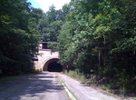
Hike or Ride through Sideling Hill Tunnel, Blueridge Mountain, Pennsylvania
Sideling Hill Tunnel is one of three original Pennsylvania Turnpike tunnels abandoned (this one in 1968) after two massive realignment projects. The others are nearby Rays Hill Tunnel, and farther west, the Laurel Hill Tunnel. It was less expensive to realign the Turnpike than to bore a second tube for four lane traffic. Sideling Hill Tunnel is 6,782 feet (2,067 m) lo... -
Visit Sidewinder Cove, Lake Mead, Arizona
Sidewinder Cove is a remote bay located on the Arizona side of Lake Mead, west of the narrows. There is some sandy and rocky shoreline accessible by boat, as well as cliffs and canyon walls. Sidewinder Cove is close to Boulder Canyon, Gilbert Canyon, Bearing Point, Canyon Point and James Bay. -
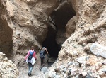
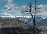
Hike Sidewinder Slot Canyon, Death Valley National Park, California
The hills at the western base of Smith Mountain seem uninteresting from a distance, yet tucked deep within them are some of the narrowest slot canyons in Death Valley. From the southern end of the old gravel pit, walk up the large alluvial fan to the south that leads to a shallow canyon with poorly cemented gravel walls. About a mile in, a major drainage joins from th... -
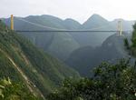
Drive across Sidu River Bridge, China
The Sidu River Bridge (Siduhe Bridge) is a 1,222 m-long (4,009 ft) suspension bridge crossing the valley of the Sidu River near Yesanguan in Badong County of the Hubei Province of the People's Republic of China. It opened to traffic on November 15, 2009. The bridge spans a 500 m (1,600 ft) deep valley of the Sidu River (a left tributary of the Qingjiang River), and ha... -
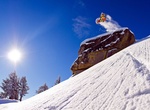
Ski/Board Sierra-at-Tahoe, California
Sierra-at-Tahoe is a ski and snowboard resort in Twin Bridges, California south of Lake Tahoe. Sierra-at-Tahoe is approximately 16 miles (26 km) south of Stateline, Nevada and 12 miles south of South Lake Tahoe on Highway 50 and is contained within the Eldorado National Forest. Sierra-at-Tahoe (often shortened to "Sierra") is a medium sized ski area in the Lake Tahoe ... -
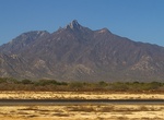
Explore Sierra de la Laguna, Baja California Sur, Mexico
The Sierra de la Laguna is a mountain range on the Baja California Peninsula of Mexico. It lies at the southern end of the peninsula in the state of Baja California Sur, and is the southernmost range of the Peninsular Ranges. The southern tip of the peninsula, including the Sierra de la Laguna, was formerly an island, and it has a distinctive flora and fauna, with man... -
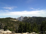
Explore Sierra de San Pedro Mártir National Park, Baja California, Mexico
Sierra de San Pedro Mártir National Park is a national park in the Mexican state of Baja California. The Park is part of the municipality of Ensenada, Baja California. The area was first explored by Europeans in 1701 by Eusebio Francisco Kino by Dominican orders. The park is known for its pine trees and granite rock formations. Sierra de San Pedro Mártir... -
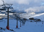
Ski or Snowboard Sierra Nevada Ski Station, Spain
The Sierra Nevada Ski Station is a ski resort in the Sierra Nevada in the province of Granada in southeastern Spain. The ski area is on the northwestern slopes of Veleta, the third highest peak in Peninsular Spain and the most southerly ski resort in Europe. The resort hosted the FIS Alpine World Ski Championships in 1996 and occasionally hosts World Cup races, the la... -
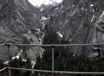
Hike to Sierra Point, Yosemite National Park
WARNING: National Park Service does not recommend that anyone take this trail. Sierra Point is a point located in Yosemite National Park at the eastern end of the valley, below Grizzly Peak, on what is essentially the southern shoulder of Half Dome. The trail used to be quite popular, but was closed due to a rock slide in the 1970s. While a portion of the trail is sti... -
Drive Sierra Vista Scenic Byway, Sierra National Forest, California
The Sierra Vista Scenic Byway is an 82.7-mile (133.1 km) route through the Sierra National Forest in the U.S. state of California. Many examples of the Sierra’s most distinctive granite domes, meadows and glacial valleys can be seen along the way. The Sierra Vista Scenic Byway begins two miles (3 km) north of the foothill community of North Fork, climbing the we... -
Relax on Siesta Key Beach, Sarasota, Florida
Siesta Beach (sometimes known as Siesta Key Beach) is a beach located on Siesta Key, Florida, United States. The sand is 99% pure quartz, soft and cool on the feet. The many awards it has earned include: “the whitest and finest sand in the world” (The Great International Beach Challenge, 1987) “The Best Sand Beach in America” (The Travel Chann... -
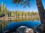
Visit Siesta Lake, Yosemite National Park, California
Siesta Lake is an alpine lake located along the Tioga Road to the south, about 13 miles east of the Crane Flat Gas Station. Swimming and picnicking are popular past-times here. -
Summit Signal Hill, Cape Town
Signal Hill (Afrikaans:Seinheuwel), or Lion's Rump, is a landmark flat-topped hill located in Cape Town, next to Lion's Head and Table Mountain. The hill was also known as "The Lion's Flank", a term now obsolete. Together with Lion's Head, Signal Hill looks like a lion sphinx. Signal flags were used to communicate weather warnings as well as anchoring instructions to ... -
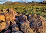
Hike Signal Hill Petroglyphs Trail, Saguaro National Park, Arizona
Signal Hill Trail is located off Signal Hill Picnic Area and include Hohokam Petroglyphs. This easy climb takes you to dozens of petroglyphs scattered around a rocky hilltop. The trail zig -zags up a small hill just north of Signal Hill Picnic Area, which is located off Golden Gate Road, 5 miles from the Red Hills Visitor Center. The trail is rough and uneven in place... -
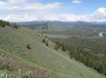
Hike Signal Mountain Trail, Grand Teton National Park, Wyoming
The Signal Mountain Trail is a 6.8-mile (10.9 km) long roundtrip hiking trail in Grand Teton National Park in the U.S. state of Wyoming. The trail begins near Signal Mountain Lodge on Jackson Lake and provides hiking access to the summit of Signal Mountain. The trail passes through Lodgepole Pine forests most of the way and the view from the summit of Signal Mountain ...


Price: $109.14