Give us feedback!


 See all

Our philosophy is simple. We want to encourage you to dream. BIG! Then we help you plan your trip, get the most out of it while you're traveling and help you share your experience with friends.
Join Now It's FREE
Dream Packages
Duration: 2 days
Price: $242.00
Price: $242.00
Duration: 5 hours
Price: $106.33
Price: $106.33
Duration: 4 hours
Price: $120.43
Price: $120.43
Duration: 9 hours
Price: $109.14
Price: $109.14
Dreams Still To Do
Checked-Off Dreams
Dreams Still To Do
Checked-Off Dreams
Advertisement
Explore Adventure Sports
-
Off-road or Hike to Sinker Reef Beach, Two Peoples Bay Nature Reserve, Albany, Western Australia
Those with four-wheel drive vehicles can also set out on Sinker Reef Track to Sinker Reef Beach and enjoy magnificent coastal views. This portion of Two Peoples Bay National Park is much more rugged than the northern side of the park. Jagged black rocks rise in rows along this entire stretch of coastline and the track to get there is about 2km in length and can be tra... -
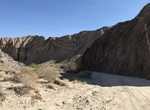
Off-road or Hike Sin Nombre Canyon, Anza-Borrego Desert State Park, California
Canyon Sin Nombre Rd is a 4.2 mile trail through southern part of Anza-Borrego Desert State Parkto Carrizo Creek Wash. -
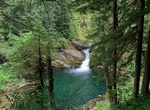
Hike Siouxon Creek Trail, Washington
Siouxon Creek Trail is a 8.7 mile out and back trail located near Amboy, Washington that features a waterfall. -
Dive Sipadan Island, Malaysia
Sipadan is the only oceanic island in Malaysia, rising 600 metres (2,000 ft) from the seabed. It is located in the Celebes Sea off the east coast of Sabah, East Malaysia (which is on the island of Borneo). It was formed by living corals growing on top of an extinct volcanic cone that took thousands of years to develop. Sipadan is located at the heart of the Indo-Pacif... -
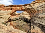
Hike to Sipapu Bridge, Natural Bridges National Monument, Utah
Sipapu Bridge is a natural bridge or arch located in the Natural Bridges National Monument in the U.S. state of Utah. The bridge spans White Canyon. Sipapu Bridge is the largest natural bridge in the park and the second largest in the United States (after Rainbow Bridge National Monument). Admire its 268-foot (82-meter) span up close with a hike to the bridge’s... -
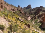
Hike Siphon Draw Trail to Flatiron Mountain, Lost Dutchman State Park, Arizona
The main Siphon Draw Trail #53 is 4 miles round trip, a very scenic hike, this trail winds up into a canyon known as Siphon Draw. It is possible to hike up the Flatiron (5.8 miles roundtrip), although it is not a designated, maintained trail all the way. It's advised that only experienced hikers in good shape attempt to hike to the top, as the climb is steep and diff... -
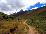
Hike Sirimon Route, Mount Kenya, Mount Kenya National Park, Kenya
The Sirimon Route starts 15 km (9.3 mi) east around the Mount Kenya Ring Road from Nanyuki. The gate is 10 km (6.2 mi) further along the track, which can be walked or driven by four-wheel drives. The track climbs up through the forest. On the northern side of the mountain there is no bamboo zone, so the forest gradually turns into moorland covered with giant heather.T... -
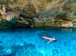
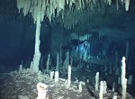
Swim in Sistema Dos Ojos Cenotes, Yucatán, Mexico
Dos Ojos (from Spanish meaning "Two Eyes"; officially Sistema Dos Ojos) is a flooded cave system located north of Tulum, on the Caribbean coast of the Yucatán Peninsula, in the state of Quintana Roo, Mexico. The exploration of Dos Ojos began in 1987 and still continues. The surveyed extent of the cave system is 81.9 kilometres / 50.9 miles and there are 28 know... -
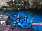
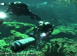
Dive Sistema Dos Ojos Cenotes, Yucatán, Mexico
Dos Ojos (from Spanish meaning "Two Eyes"; officially Sistema Dos Ojos) is a flooded cave system located north of Tulum, on the Caribbean coast of the Yucatán Peninsula, in the state of Quintana Roo, Mexico. The exploration of Dos Ojos began in 1987 and still continues. The surveyed extent of the cave system is 81.9 kilometres / 50.9 miles and there are 28 know... -
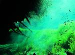
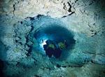
Dive Sistema Naranjal (Cenote Naharon & Cenote Mayan Blue), Yucatán, Mexico
Sistema Naranjal in Yucatán, Mexico includes Cenote Naharon and Cenote Mayan Blue. Sistema Naranjal is most likely part of the much larger Sistema Ox Bel Ha, the world’s largest underwater cave. Cenote Naharon (“the dark cave") is different from other caves in the area with most of its walls and formations are stained a deep black. Cenote Mayan Bl... -
Dive Sistema Nohoch Nah Chich (Casa Cenote, Cenote Manati), Yucatán, Mexico
Sistema Nohoch Nah Chich (from Spanish and Yucatec Maya meaning "Giant Birdcage System") is an extensive water filled cave system connected with the Caribbean Sea via a coastal spring called a variety of names, including Casa Cenote for the restaurant located nearby, but also Cenote Manati, or Cenote Tankah. The explored cave system extends to approximately 8 kilomete... -
Dive Sistema Ox Bel Ha Cenote, Yucatán, Mexico
Ox Bel Ha ("Three Paths of Water"), officially Sistema Ox Bel Ha, is a cave system in Quintana Roo, Mexico. It is the longest explored underwater cave in the world and ranking no. 4 including dry caves. As of October 2011 the surveyed length is 231.2 kilometers (143.7 mi) of underwater passages. -
Dive Sistema Sac Actun Cenotes, Yucatán, Mexico
Sistema Sac Actun (from Spanish and Yucatec Maya meaning "White Cave System") is an underwater cave system situated along the Caribbean coast of the Yucatán Peninsula with passages to the north and west of the village of Tulum. Exploration started from Gran Cenote 5 kilometers (3.1 mi) west of Tulum. The whole of the presently explored cave system lies within t... -
Dive Sisters' Islands Marine Park, Singapore
Sisters’ Islands Marine Park is a 400,000 square metre(40ha) marine park located in Southern Islands planning area, Singapore, which was designated a marine protected area (MPA) by the Government of Maritime and Port Authority of Singapore in 2014. The park encompasses the land and waters surrounding Sisters' Islands, and also covers the western coasts of both S... -
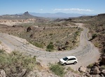
Drive Sitgreaves Pass, Arizona
Sitgreaves Pass is along the old Route 66 and tops out at 3,550 feet. The pass was named for Captain Lorenzo Sitgreaves, who traveled through the area in 1851. It's a very narrow, two-lane blacktop with no shoulders, crazy switchbacks and steep drop-offs plunging thousands of feet down. There are memorials to deceased people whose cremains are scattered at the site. ...


Price: $99.36