Give us feedback!


 See all

Our philosophy is simple. We want to encourage you to dream. BIG! Then we help you plan your trip, get the most out of it while you're traveling and help you share your experience with friends.
Join Now It's FREE
Dream Packages
Duration: 7 hours
Price: $179.00
Price: $179.00
Duration: 8 hours
Price: $83.37
Price: $83.37
Duration: 8 hours
Price: $208.72
Price: $208.72
Duration: 3 hours
Price: $173.83
Price: $173.83
Dreams Still To Do
Checked-Off Dreams
Dreams Still To Do
Checked-Off Dreams
Advertisement
Explore Adventure Sports
-
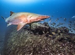
Wreck Dive USS Tarpon (SS-175), Cape Hatteras, North Carolina
USS Tarpon (SS-175), second ship of this name, was laid down on 22 December 1933 at Groton, Connecticut, by the Electric Boat Corporation; launched on 4 September 1935; sponsored by Miss Eleanore Katherine Roosevelt, daughter of Assistant Secretary of the Navy Henry L. Roosevelt; and commissioned on 12 March 1936, Lt. Leo L. Pace (Class of 1921) in command. Tarponoper... -
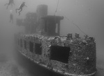
Wreck Dive USS Tucker (DD-374), Malo, Vanuatu
USS Tucker (DD-374) was one of 18Mahan-class destroyers built for the United States Navy and was commissioned in 1936.Tucker's main battery consisted of five dual-purpose 38 caliber 5-inch (127 mm) guns. First assigned to the United States Battle Fleet in San Diego, California,Tuckeroperated along the West Coast and in the Hawaiian Islands. After participating in nava... -
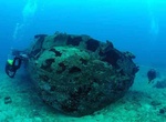
Wreck Dive USS YO-257, Oahu, Hawaii
USS YO-257 was a Yard Oiler of the United States Navy that was scuttled two miles off Waikiki, Honolulu, Hawaii in 1989. Built in the 1940s,YO-257saw action in World War II, the Korean War, and in the Vietnam War. From 16 September to 12 November 1963 the ship was temporarily loaned to the Coast Guard to assist in the construction of a LORAN radio navigation station i... -
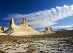
Explore Ustyurt Plateau, Uzbekistan & Kazakhstan
The Ustyurt Plateau is a clay and stony desert in Uzbekistan and Kazakhstan, between the Aral Sea and the Caspian Sea. There are areas of sandy desert. The Ustyurt is often called the boundary separating Europe from Asia. The flat desert terrain is broken by chalk deposits that create a surreal landscape. It has an area of about 77,000 square miles (about 200,000 squ... -
Sail U.S. Virgin Islands (USVI)
The US Virgin Islands (USVI) are comprised of 4 large islands: St.Croix, St. Thomas, St. John and Water Island. The islands are located approximately 1800 kilometers from Miami, Florida. The islands had previously been possessions of several European countries with the USA purchasing them in 1917. Tourism is the primary industry that drives the economic engine of USVI... -
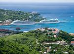
Cruise U.S. Virgin Islands (USVI)
St. Thomas is the capital of the U.S. Virgin Islands, its most developed city and the center of island life. St. Thomas offers a full spectrum of activities including snorkeling, SCUBA diving, golf, hiking and sailing along with dramatic mountainous scenery, crystal clear water and idyllic white sand beaches with swaying palm trees. St. Thomas’ city of Charlotte... -
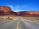
Drive Utah Scenic Byway 279, Utah
State Route 279 is a state highway in the U.S. state of Utah. The highway was constructed in 1962–1963 to service the Cane Creek potash mine and processing plant southwest of Moab. The highway was named one of the most beautiful highways opened to traffic in 1963. The entire length of SR-279 has been designated the Potash – Lower Colorado River Scenic Bywa... -
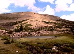
Hike Utah's Highline Trail
The Highline Trail is a trail in the Uinta Mountain Range of Utah that crosses the range from the west to the east. The trail, sometimes called the Uinta Highline Trail, follows the crest of the Uintas and runs 95.7 miles (154.0 km) (if one hikes its full length all the way to U.S. Route 191 (Utah)). Much of the trail is located in the High Uintas Wilderness. The trai... -
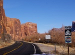
Camp along Utah State Route 128
State Route 128 (SR-128) is a state highway in the U.S. state of Utah. The entire length of the highway has been designated the Upper Colorado River Scenic Byway, as part of the Utah Scenic Byways program. This road also forms part of the Dinosaur Diamond Prehistoric Highway, a National Scenic Byway. Residents of Moab frequently refer to SR-128 as "the river road", af... -
Drive Utah State Route 211 (Canyonlands Needles District), Utah
State Route 211 is a state route in Utah that is an access road for Newspaper Rock State Historic Monument and the Needles district of Canyonlands National Park. The entire length of the highway has been designated theIndian Creek Corridor Scenic Byway. The highway begins near Church Rock, a notable rock formation along U.S. Route 191 between Moab and Monticello.... -
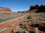
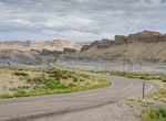
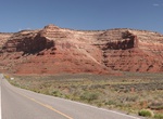
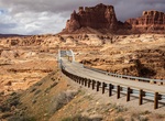
Drive Utah State Route 24 (SR-24), Utah
Utah State Route 24 (SR-24) is a state highway in south central Utah which runs south from Salina through Sevier County then east through Wayne County and north east through Emery County. At a total of 163.294 miles (262.796 km), it is the longest contiguous state route in Utah. A portion of the highway has been designated theCapitol Reef Scenic Bywayas part of the Ut... -
Drive Utah State Route 261, Utah
Utah State Route 261 is a state highway located entirely within south-central San Juan County, Utah. It runs 34 miles (55 km) north, from the junction of U.S. Route 163 (3 miles (5 km) north of Mexican Hat), to the junction with State Route 95, just east of Natural Bridges National Monument. The highway is part of the Utah section of the Trail of the Ancients, a Natio... -
Drive Utah State Route 95, Utah
State Route 95 or Bicentennial Highway is a state highway located in the southeast of the U.S. state of Utah. The highway is an access road for tourism in the Lake Powell and Cedar Mesa areas, notably bisecting Bears Ears National Monument and providing the only access to Natural Bridges National Monument. The highway does not serve any cities, but the small town of H... -
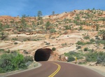
Drive Utah State Route 9 (Zion Park Scenic Byway), Utah
State Route 9 (SR-9) is a state highway in southern Utah, serving Zion National Park. It starts at the western terminus at exit 16 on I-15, passing through Zion National Park, and ending at the eastern junction with US-89. The entire length of the highway has been designated the Zion Park Scenic Byway. There is a fee to travel through Zion National Park, but the Zion-... -
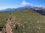
Hike Ute Trail, Rocky Mountain National Park, Colorado
One section of the the Ute Trail runs from the Alpine Visitor Center at Fall River Pass down to Milner Pass near Poudre Lake.

Price: $176.03